geo.wikisort.org - Reservoir
The Shapo Reservoir (Chinese: 沙坡水库) is located 5 km south of Haikou city, Hainan, China, south of Shapo Village at Chengxi Town.[1][2][3][4][5][6][7][8][9][10][11][12] The purpose of this reservoir is to prevent floods and conserve water to supply to Haikou. It is roughly 2 km long. A single dam is located at the northeast bank.
| Shapo Reservoir 沙坡水库 | |
|---|---|
 The grey area centre right indicates the location of the dam (see photo in article) | |
 Shapo Reservoir 沙坡水库 | |
| Location | Haikou, Hainan |
| Coordinates | 19.95442°N 110.32473°E |
| Type | Reservoir |
| Primary outflows | Meishe River |
| Basin countries | China |
| Islands | 1 |
Water released from this dam flows into a spillway and then starts the Meishe River. This narrow river then flows eastward under Longkun Road just south of the Haikou East Railway Station. It then turns north, runs past the Meishe River National Wetland Park, and empties into the Haidian River.
Design and construction
The Shapo Reservoir was designed and is administered within Longhua District's jurisdiction.[13]
Construction of the reservoir started in 1959 and was completed in 1964. Reinforcements were made in 2013.
Description
The reservoir

Shapo is a medium-size reservoir being 27.46 km2. It can hold 14,190,000 cubic metres of water. The normal water level is 30 metres, and at that level, it contains 11,320,000 cubic metres of water. With the exception of the concrete dam, its banks are entirely natural and mostly tree-lined.
The dam

On the northeast bank there is roughly 300-metre-long dam. It has two outlets, a set of three floodgates at its south end, and a small outlet at the north end. Water from the north outlet follows a narrow, concrete channel that empties into the Meishe River. Water from the main floodgates also runs into the same river after flowing down a banked spillway.
On top of the dam there is a narrow road for vehicular traffic.
Usage
The primary purpose of the reservoir is for water storage and flood prevention. Fishing and boating is prohibited. However, some fishermen are able to circumvent or defeat fences and are found fishing along the banks.
Gallery
 One of the three floodgates
 Dam road
 Spillway viewed from the bottom
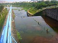 Spillway viewed from the top


References
- "期待海口沙坡水库垃圾治理从治本出发_海口新闻网_海口重点新闻网站".
- L_3187. "龙华区保护沙坡水库和美舍河 拆6万平米违建--人民网海南视窗--人民网".
- 网易. "海口沙坡水库边被垃圾场废品站包围 记者多次反映无果(组图)_网易新闻".
- 网易. "南海网报道引重视 多部门将解决沙坡水库垃圾盘踞问题_网易新闻".
- 网易. "南海网报道引重视 海口环卫连夜整改沙坡水库环境_网易新闻".
- 网易. "水库周边岂容垃圾污染_网易新闻".
- 帆帆. "海口高坡村3天清走200多吨垃圾 腾出空地种树种花_新闻中心_大河网".
- "美舍河及沙坡水库周边环境综合整治_海南新闻中心_海南在线_海南一家".
- "海口沙坡水库被垃圾围困 回应:人手有限_海南新闻中心_海南在线_海南一家".
- "海口启动沙坡水库周边土地整治 苍东村两宗违建被拆_海南新闻中心_海南在线_海南一家".
- "[原创][贴图] 美丽的沙坡水库! - 钓友日记 - 中国钓鱼频道-钓鱼网".
- "记者多次反映沙坡水库垃圾问题无果 涉事12345话务员被处理-新闻中心-南海网".
- Frodesiak, Anna (8 December 2016). "English: Shapo Reservoir information sign" – via Wikimedia Commons.
External links
Hainan topics | |
|---|---|
Haikou (capital) | |
| General |
|
| Geography |
|
| Flora and fauna |
|
| Media |
|
| Transportation |
|
| Education |
|
| Demographics |
|
| Buildings and structures |
|
| Cuisine | |
| Visitor attractions |
|
| |
This Hainan location article is a stub. You can help Wikipedia by expanding it. |
Другой контент может иметь иную лицензию. Перед использованием материалов сайта WikiSort.org внимательно изучите правила лицензирования конкретных элементов наполнения сайта.
WikiSort.org - проект по пересортировке и дополнению контента Википедии