geo.wikisort.org - Reservoir
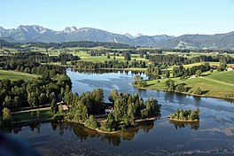
The Schwaltenweiher is a reservoir in the Ostallgäu foothills of the Alps in Bavaria, Germany. It lies 14 km (8.7 mi) from the Allgäu Alps between the towns of Seeg and Rückholz. It was named after the Schwaltenmühle mill built beside it, which was in turn named after the Schwalt or Schwald family. It is now used for bathing and fishing.
This article may be expanded with text translated from the corresponding article in German. (April 2011) Click [show] for important translation instructions.
|
| Schwaltenweiher | |
|---|---|
 | |
 Schwaltenweiher | |
| Location | Ostallgäu, Bavaria, Germany |
| Coordinates | 47°39′02″N 10°34′31″E |
| Type | Reservoir |
History
Maximilian I, Holy Roman Emperor set aside the lake in 1514 for fishing and hunting waterfowl. His neighbouring Schloss Falkenberg (at what is now Goldhasen am Westufer) was destroyed by Imperial troops during the Thirty Years' War to prevent it falling into Swedish hands. The lake has passed through several owners over the following centuries, and is still in private hands. Notable guests there have been Theodor Heuss, Horst Köhler and Theo Waigel.
На других языках
[de] Schwaltenweiher
Der Schwaltenweiher ist ein Stauweiher im Ostallgäuer Voralpenraum. Das Gewässer liegt 14 km von den Allgäuer Alpen entfernt zwischen den Gemeinden Seeg und Rückholz. Heutzutage wird der Schwaltenweiher als Badesee und zur Fischzucht genutzt.- [en] Schwaltenweiher
Другой контент может иметь иную лицензию. Перед использованием материалов сайта WikiSort.org внимательно изучите правила лицензирования конкретных элементов наполнения сайта.
WikiSort.org - проект по пересортировке и дополнению контента Википедии