geo.wikisort.org - Reservoir
Pyramid Lake is the geographic sink of the basin of the Truckee River, 40 mi (64 km) northeast of Reno, Nevada, United States.
This article uses bare URLs, which are uninformative and vulnerable to link rot. (August 2022) |
| Pyramid Lake | |
|---|---|
 The tufa formation that gives Pyramid Lake its name. | |
 Pyramid Lake Location in Nevada  Pyramid Lake Pyramid Lake (the United States) | |
| Location | Washoe County, Nevada, United States |
| Coordinates | 40°03′45″N 119°33′49″W |
| Lake type | endorheic salt lake |
| Etymology | pyramidal limestone columns |
| Primary inflows | Truckee River |
| Catchment area | 1,825.8 sq mi (4,729 km2) |
| Max. length | 29.8 mi (48.0 km) |
| Max. width | 8.7 mi (14.0 km) |
| Surface area | 188 sq mi (490 km2) |
| Max. depth | 356 ft (109 m) |
| Water volume | 23,660,000 acre-feet (29.18 km3) |
| Surface elevation | 3,796 ft (1,157 m) (1980 data)[1] |
| Islands | Anaho Island |
| References | GNIS ID: 856349[1] |
Nevada Historical Marker | |
| Reference no. | 18[2] |
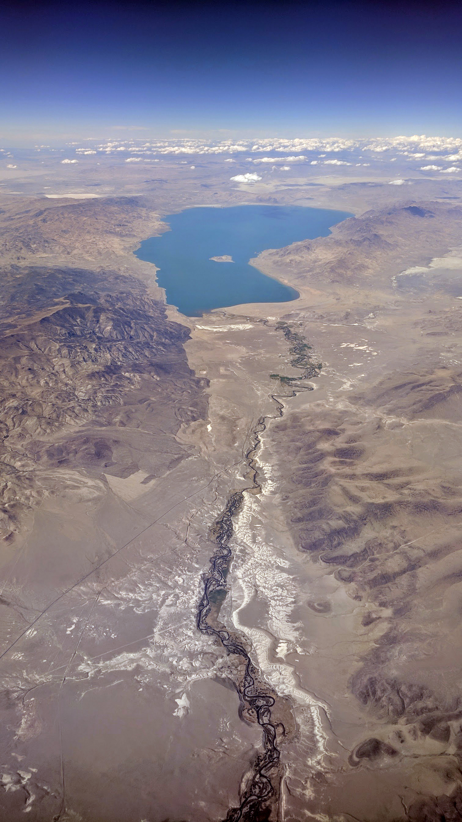
Pyramid Lake is the biggest remnant of ancient Lake Lahontan, the colossal inland sea that once covered most of Nevada.[3] It is approximately 15 miles long and 11 miles wide, covering 112,000 acres entirely enclosed within the Pyramid Lake Paiute Tribe Reservation.[4]
Pyramid Lake is fed by the Truckee River, which is mostly the outflow from Lake Tahoe. The Truckee River enters Pyramid Lake at its southern end. Pyramid Lake is an endorheic lake. It has no outlet, with water left only by evaporation, or sub-surface seepage. The lake has about 10% of the area of the Great Salt Lake, but it has about 25% more volume. The salinity is approximately 1/6 that of sea water. Although clear Lake Tahoe forms the headwaters that drain to Pyramid Lake, the Truckee River delivers more turbid waters to Pyramid Lake after traversing the steep Sierra terrain and collecting moderately high silt-loaded surface runoff.
The north and east sides of the lake have been restricted to the public and non-Tribal members for nearly a decade. In 2011, the Tribal Nation made the decision to close these areas due to the desecration of sacred sites. When visiting, it is recommended to take note of the Tribal protocols and restricted areas.[3]
History[5]

A remnant of the Pleistocene Lake Lahontan (~890 feet deep), the lake area has long been inhabited by the Paiute, who ancestrally fished the Tui chub and Lahontan cutthroat trout from the lake.[6]
Archeological evidence shows that human populations lived in this area between 9500 B.C.E. and 1400 A.D. Excavations have uncovered tools, weapons, clothing, food, and mummified bodies in the area.[7] The Paiute people in this region call themselves Cui-ui eaters, named after the fish that helped sustain the population. The Native name for the lake is Cui-ui Pah.[8]
A tufa rock formation near the lake called the "Stone Mother," is a central sacred site to the Paiute people of Pyramid Lake and serves as the creation story for the lake.[5]
The lake was first mapped by John C. Frémont, an American who gave the lake its English title, in 1844.[9] The name comes from a large rock formation that resembles a bent pyramid.
In the 19th century, two battles were fought near the lake, major actions in the Paiute War. In the 1960s, a marker was placed commemorating these battles.[10]

Because of water diversion beginning in 1905 by Derby Dam through Truckee Canal to Lahontan reservoir, the lake's existence was threatened, and the Paiute sued the Department of the Interior. By the mid-1970s, the lake had lost 80 feet of depth, and according to Paiute fisheries officials, the lake's life was seriously under threat. According to documentary filmmaker John Pilger, the irrigation scheme for which water was diverted was an economic failure.[10]
- Chronology
- 1860 – The Pyramid Lake War: Paiute natives and Euro-American settlers clashed.[11]
- 1903 – Irrigation diversion of the Truckee via the Derby Dam contributed to the decline and eventual extinction in Pyramid Lake of the Lahontan cutthroat trout, which are now stocked.[12][13]
- 1936 – The Pyramid Lake Paiute Tribe approved their constitution and by-laws.[14]
- 1987 – A water quality model was completed for the Truckee River.[15]
Geography
Pyramid Lake is located in southeastern Washoe County in western Nevada. It is in an elongated intermontane basin between the Lake Range on the east, the Virginia Mountains on the west, and the Pah Rah Range on the southwest. The Fox Range and the Smoke Creek Desert lie to the north.
In a parallel basin to the east of the Lake Range is Winnemucca Lake, now a dry lake bed. Prior to the construction of the Derby Dam in 1905, both lake levels stood at near 3,880 ft (1,180 m) above sea level.[16] Following the dam's completion, the water levels dropped to 3,867 ft (1,179 m) and 3,853 ft (1,174 m) for Pyramid and Winnemucca, respectively.[17] In 1957, the Pyramid Lake level was at 3,802 ft (1,159 m) and the dry Winnemucca Lake bed at 3,780 ft (1,150 m)[18] had been dry since the 1930s.
Pyramid Lake is the largest remnant of ancient Lake Lahontan, which covered much of northwestern Nevada at the end of the last ice age. It was the deepest point of Lake Lahontan, reaching an estimated 890 feet (270 m) due to its low level relative to the surrounding basins.
Sutcliffe is on the west shore of Pyramid Lake along State Route 445. Nixon is on the Truckee River to the southeast of the lake on State Route 447.[19]
The name of the lake comes from the impressive cone- or pyramid-shaped tufa formations found in the lake and along the shores. The largest such formation, Anaho Island, is home to a large colony of American white pelicans and is restricted for ecological reasons. Access to the Needles, another spectacular tufa formation at the northern end of the lake, has also been restricted due to recent vandalism.[20]
The Pyramid
The Pyramid (39°58′48″N 119°30′06″W), also known as Fremonts Pyramid and Pyramid Island, is a small island near the southeastern shore of the lake.[21] It is located approximately 1.2 miles northeast of Anaho Island and slightly less than six miles from the community of Sutcliffe. The white band seen to the east of the island is composed of calcium carbonate which came from when the lake was at or near its overflow point.[22]
Fish
Major fish species include the Cui-ui lakesucker, which is endemic to Pyramid Lake, the Tui chub and Lahontan cutthroat trout (the world record cutthroat trout was caught in Pyramid Lake). The former is endangered, and the latter is threatened. Both species were critical to the Paiute people in pre-contact times.[6] The Lahontan cutthroat was called "Hoopagaih" by the Paiute people.[23] As they are both obligate freshwater spawners, they rely on sufficient inflow to allow them to run up the Truckee River to spawn, otherwise their eggs will not hatch.[13]
Diversion of the Truckee for irrigation at Derby Dam beginning in 1905 reduced inflow and the lake level to such an extent that stream flow is rarely sufficient for spawning. The Truckee Canal diverts water used to irrigate croplands in Fallon. The dam lacks fish ladders, which prevents upstream spawning. By 1939 the Lahontan cutthroat trout (the "salmon-trout" as described by Frémont) became extinct in Pyramid Lake and its tributaries. They were replaced with hatchery trout from outside the watershed.[24]
However, in 1979 a remnant population of the original Pyramid Lake cutthroat trout was discovered in a small brook on Pilot Peak, on the Nevada/Utah border, by Dr. Robert Behnke of Colorado State University while he was looking for the Bonneville cutthroat trout, another subspecies of the cutthroat trout. The fish were tiny and in poor condition, but Behnke identified the fingerlings as the missing Pyramid Lake variety.[25][26]
Subsequent DNA testing of a museum specimen has shown his identification to be correct. The fish had been dumped in the creek in the early 20th century. A brood stock was raised at the U.S. Fish and Wildlife Service's Lahontan National Fish Hatchery in Gardnerville, Nevada, and a successful reintroduction effort was mounted by the USFWS and the Pyramid Lake Paiute Tribe. As of 2017, 24 pound Pyramid Lake Lahontan cutthroat trout are again being caught from the Lake's waters.[24][27]
The fish are doing very well, according to the USFWS project head Lisa Heki. The fish have also been placed in California's Fallen Leaf Lake, upstream of Pyramid Lake, and elsewhere. Fish populations are now sustained by several tribally-run fish hatcheries and state and federal agencies.[28] The Pyramid Lake Lahontan cutthroat trout is one of the largest inland trout species in the world.[29]
Climate
The following data are for the census-designated place (CDP) of Sutcliffe, NV, located on the shore of Pyramid Lake.
| Climate data for Sutcliffe, NV | |||||||||||||
|---|---|---|---|---|---|---|---|---|---|---|---|---|---|
| Month | Jan | Feb | Mar | Apr | May | Jun | Jul | Aug | Sep | Oct | Nov | Dec | Year |
| Record high °F (°C) | 65 (18) |
73 (23) |
76 (24) |
92 (33) |
99 (37) |
103 (39) |
105 (41) |
103 (39) |
98 (37) |
90 (32) |
79 (26) |
73 (23) |
105 (41) |
| Average high °F (°C) | 44.3 (6.8) |
47.7 (8.7) |
55.2 (12.9) |
61.5 (16.4) |
70.0 (21.1) |
79.8 (26.6) |
88.8 (31.6) |
87.4 (30.8) |
78.5 (25.8) |
65.5 (18.6) |
53.2 (11.8) |
45.0 (7.2) |
64.7 (18.2) |
| Average low °F (°C) | 29.0 (−1.7) |
31.2 (−0.4) |
35.8 (2.1) |
40.0 (4.4) |
47.5 (8.6) |
55.4 (13.0) |
63.3 (17.4) |
62.8 (17.1) |
55.3 (12.9) |
45.2 (7.3) |
36.3 (2.4) |
29.6 (−1.3) |
44.3 (6.8) |
| Record low °F (°C) | 9 (−13) |
−4 (−20) |
10 (−12) |
22 (−6) |
28 (−2) |
36 (2) |
46 (8) |
43 (6) |
29 (−2) |
14 (−10) |
14 (−10) |
−8 (−22) |
−8 (−22) |
| Average precipitation inches (mm) | 1.35 (34) |
0.76 (19) |
0.70 (18) |
0.44 (11) |
0.63 (16) |
0.56 (14) |
0.17 (4.3) |
0.18 (4.6) |
0.26 (6.6) |
0.46 (12) |
0.85 (22) |
0.95 (24) |
7.31 (185.5) |
| Average snowfall inches (cm) | 2.0 (5.1) |
1.3 (3.3) |
0.7 (1.8) |
0.2 (0.51) |
0 (0) |
0 (0) |
0 (0) |
0 (0) |
0 (0) |
0.1 (0.25) |
0.3 (0.76) |
0.9 (2.3) |
5.5 (14.02) |
| Source: http://www.wrcc.dri.edu/cgi-bin/cliMAIN.pl?nv7953 | |||||||||||||
Water quality
Because of the endangered species present and because the Lake Tahoe Basin comprises the headwaters of the Truckee River, Pyramid Lake has been the focus of several water quality investigations, the most detailed starting in the mid-1980s. Under direction of the U.S. Environmental Protection Agency, a comprehensive dynamic water quality computer model, the DSSAM Model was developed[15] to analyze impacts of a variety of land use and wastewater management decisions throughout the 3,120-square-mile (8,100 km2) Truckee River Basin. Analytes addressed included nitrogen, reactive phosphate, total dissolved solids, dissolved oxygen and nine other parameters. Based on the use of the model, some decisions have been influenced to enhance Pyramid Lake water quality and aid the viability of Pyramid Lake biota. Another contaminant of interest is mercury, introduced to Pyramid Lake from the Truckee River.[30] It is suggested that mercury remediation efforts be carefully considered such that methylmercury production are not enhanced.[30]
Salinity increased from 3.7 to 5 g/L, and the pH level is about 9. Temperature ranges between near freezing (32 °F (0 °C)) to over 68 °F (20 °C).[31]

Media
Pyramid Lake was used as a stand-in for the Sea of Galilee in the 1965 biblical film, The Greatest Story Ever Told.[32] Also, in 1961, part of The Misfits was filmed nearby.[33]
See also
- Black Rock Desert
- Carson Sink
- Honey Lake
- Humboldt Sink
- Walker Lake (Nevada)
References
- "Query Form For The United States And Its Territories". U.S. Board on Geographic Names. Retrieved 2010-05-18.
U.S. Geological Survey Geographic Names Information System: Pyramid Lake (856349); The Pyramid (848623), The Needle Rocks (847213) - Nevada Historical Marker 18
- "Pyramid Lake Nevada | The official site for the Pyramid Lake Paiute Tribe, Nevada". Retrieved 2021-01-31.
- http://plpt.nsn.us/
- "Stonemother Story". plpt.nsn.us. Retrieved 2021-06-04.
- Egan, Ferol. Sand in a Whirlwind: The Paiute Indian War of 1860. University of Nevada Press: Nevada. ISBN 0-87417-097-4
- Wheeler, Sessions (2001). The Desert Lake. Caldwell, Idaho: Caxton Press. p. 23. ISBN 0-87004-139-8.
- "8. The People of Pyramid Lake (U.S. National Park Service)". www.nps.gov. Retrieved 2021-06-04.
- Mojave Desert: John Charles Fremont (1813–1890)
- Pilger, John (1976). Pyramid Lake Is Dying UK: ATV Colour Production.
- "Pyramid Lake War".
{{cite web}}: CS1 maint: url-status (link) - Wheeler, Sessions S. (1967). The Desert Lake: The Story of Nevada's Pyramid Lake. Caxton Press. p. 96. ISBN 978-0870041396. Retrieved 2018-11-02.
- Draft Environmental Impact Statement for the Truckee Meadows Flood Control Project Nevada, General Reevaluation Report (PDF) (Report). Vol. 1. US Army Corps of Engineers. May 2013. p. 9. Retrieved 2018-11-02.
- "Pyramid Lake Paiute Tribe". Retrieved 2010-05-30.
- C.M.Hogan,Marc Papineau et al. Development of a dynamic water quality simulation model for the Truckee River, Earth Metrics Inc., Environmental Protection Agency Technology Series, Washington D.C. (1987)
- Granite Range, Nevada, 1°x1° Topographic Quadrangle, USGS, 1886 and Reno, Nevada, 30x30 Minute Topographic Quadrangle, USGS, 1891
- New Wadworth, Nevada, 30x30 Minute Topographic Quadrangle, USGS, 1942 reprint of 1894 map with 1911 lake levels
- Nixon, Nevada. 15 Minute Topographic Quadrangle, USGS, 1957
- Reno, Nevada, 30x60 Minute Topographic Quadrangle, USGS, 1980
- Mueller, Michael D. (2004-04-21). "Reno's best kept secret". Zephyr. Archived from the original on 2007-07-11. Retrieved 2007-11-09. (dead link: )
- U.S. Geological Survey Geographic Names Information System: The Pyramid
- Larry Benson. "The Tufas of Pyramid Lake, Nevada". pubs.usgs.gov.
- Wheeler, Sessions (2001). The Desert Lake. Caldwell, Idaho: Caxton Press. p. 92. ISBN 0-87004-139-8.
- Peacock, Mary M.; Hekkala, Evon R.; Kirchoff, Veronica S.; Heki, Lisa G. (2017). "Return of a giant: DNA from archival museum samples helps to identify a unique cutthroat trout lineage formerly thought to be extinct". Royal Society Open Science. Royal Society Publishing. 4 (11): 171253. doi:10.1098/rsos.171253. PMC 5717685. PMID 29291110.
- Hickman, Terry J.; Behnke, Robert J. (1979). "Probable Discovery of the Original Pyramid Lake Cutthroat Trout". The Progressive Fish-Culturist. 41 (3): 135–137. doi:10.1577/1548-8659(1979)41[135:PDOTOP]2.0.CO;2.
- "Farewell to a Legend". Colorado Trout Unlimited. Archived from the original on 2016-03-04. Retrieved 2013-11-10.
- "Lahontan National Fish Hatchery Complex". Fish and Wildlife Service. Retrieved 2019-02-13.
- DeLong, Jeff. "Giant Cutthroats Show Efforts to Restore Native Fish to Pyramid Lake Working." Reno Gazette-Journal. n.p., 25 Feb. 2013.
- Spahr, Robin; Region, United States. Forest Service. Intermountain (1991). Threatened, endangered, and sensitive species of the Intermountain region. U.S. Dept. of Agriculture, Forest Service, Intermountain Region. p. 86. Retrieved 12 August 2013.
- Blum, Mitchell; Gustin, Mae Sexauer; Swanson, Sherman; Donaldson, Susan G. (August 2001). "Mercury in Water and Sediment of Steamboat Creek, Nevada: Implications for Stream Restoration". Journal of the American Water Resources Association. 37 (4): 795–804. Bibcode:2001JAWRA..37..795B. doi:10.1111/j.1752-1688.2001.tb05512.x. S2CID 128613091.
- "PYRAMID LAKE". wldb.ilec.or.jp. Retrieved 13 September 2017.
- Land, Barbara; Myrick Land (1995). A short history of Reno. Reno, Nevada: University of Nevada Press. p. 67. ISBN 978-0-87417-262-1.
- James Goode (1986) [First Published 1963 as "The Story of The Misfits"]. The Making of the Misfits. Limelight Editions. pp. 55, 123. ISBN 0-87910-065-6.
External links
Authority control | |
|---|---|
| General | |
| National libraries | |
| Other | |
На других языках
[de] Pyramid Lake (Nevada)
Der Pyramid Lake [.mw-parser-output .IPA a{text-decoration:none}ˈpɪrəmɪd ˌleɪk] (wörtlich „Pyramidensee“) ist ein abflussloser See im US-Bundesstaat Nevada. Er hat eine Fläche von 487 km² und befindet sich etwa 60 km nordöstlich von Reno im Großen Becken. Der etwa 40 km lange und 20 km breite See wird über den Truckee River vom Lake Tahoe gespeist.- [en] Pyramid Lake (Nevada)
[es] Lago Pirámide
El lago Pirámide (en inglés: Pyramid Lake) es un lago salado de Estados Unidos, localizado en el estado de Nevada.[fr] Pyramid Lake (Nevada)
Pyramid Lake est un lac salé endoérique, d'une superficie d'environ 487 km2, dans le grand bassin de la partie nord-ouest du Nevada. Il est situé dans le sud du comté de Washoe à 64 km au nord-est de Reno, le long du versant est des Monts de Virginie. Sa surface est à 1 155 mètres d'altitude.[it] Lago Pyramid (Nevada)
Il Pyramid (in lingua inglese: Pyramid Lake) è un lago endoreico presente nel bacino idrografico del fiume Truckee, suo immissario. Si trova a 64 km a nord-est di Reno, in Nevada.[ru] Пирамид (озеро, Невада)
Пирамид (англ. Pyramid Lake) — озеро в Неваде, США. Расположено в 64 км к северо-востоку от города Рино. Находится на высоте 1157 м над уровнем моря. Размеры озера 48 на 14 км. Озеро питает впадающая в него река Траки, стока из озера нет. Солёность воды составляет примерно 1/6 от морской. Единственный известный водоём, где обитает находящаяся на грани исчезновения рыба куи-уи[en] (Chasmistes cujus).Другой контент может иметь иную лицензию. Перед использованием материалов сайта WikiSort.org внимательно изучите правила лицензирования конкретных элементов наполнения сайта.
WikiSort.org - проект по пересортировке и дополнению контента Википедии