 Connection between Lago della Battaglia and Lac Vert.
 Lac Vert (2485m), Val d'Ayas, Italy.
 Lac du Couloir (2606m), Val d'Ayas, Italy.
 Corno Bussola (Mont de Boussolaz, 3022 m), a mountain in the Pennine Alps located in the Monte Rosa foothills of the Aosta Valley.
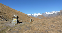 Palasinaz's mountain top view from Estoul.
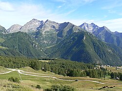 Estoul, start of the excursion to Arp Refuge.
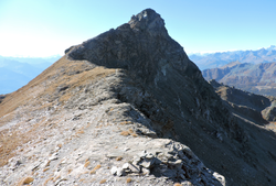 Corno Bussola (Aosta Valley, Italy) ridge from the East
 Lago Verde, seen from below - Palasinaz Lakes (Aosta Valley, Italy)
geo.wikisort.org - Reservoir
The Palasinaz Lakes (Laghi Palasinaz in Italian) are a group of lakes located in the Italian Alps, in the Aosta Valley region of northern Italy. They are of glacial origin and are situated in the southern foothills of the Monte Rosa group and are accessible from the villages of Brusson and Champoluc. The group is composed of the following lakes: the Lac Long, the Lago Pocia, the Lac du Couloir, the Lac Vert, and, the Lago della Battaglia.[1]
| Palasinaz Lakes | |
|---|---|
| Laghi Palasinaz (Italian) | |
 Satellite View of the Lakes Palasinaz | |
 Palasinaz Lakes Location of the Palasinaz Lakes in northern Italy | |
| Location | Aosta Valley, Italy |
| Group | Lac Long, Lac Pocia, Lac du Couloir, Lac Vert, Lago della Battaglia |
| Coordinates | 45.7884°N 7.7572°E |
| Etymology | The name Palasinaz derives from the term "patois", which stands for steep pasture. |
| Water volume | 0.70354 km3 (570,370 acre⋅ft) |
| Surface elevation | 2,668 m (8,753 ft) |
| Settlements | Estoul; Brusson |
Above them rises Corno Bussola (3,023 m [9,918 ft])—or Mont de Boussolaz—a mountain in the Pennine Alps.[2]
Location

The Palasinaz Lakes are located in the Valle d'Ayas, in the North-western region of the Aosta Valley, in the province of Aosta. This is one of the mountainous regions of Italy along the border with France and Switzerland. The Val d'Ayas denomination is modern, mainly used following the birth of mountaineering. The territory of Ayas, at the top of the valley, then became a pole of attraction. The previous cartography uses the denomination "Val Challant" or "Val de Challant-Ayas".
Brusson
The municipality of Brusson is 1,338 m (4,390 ft) above sea level, is located in the middle of Val d'Ayas, between the town of Challand-Saint-Anselme and the city of Ayas in the Aosta Valley. The village is home to 852 inhabitants, who recognise both French and Italian as languages. Brusson is a tourist destination, characterized by a particularly mild climate; the landscape is full of springs and lakes and is the destination for walks in the summer. In winter, Brusson is a destination for many cross-country and Nordic skiing enthusiasts, offering over 30 km (19 mi) of slopes, that have been host to various international ski competitions.[3]
Estoul
The village of Estoul can be reached from Brusson, where the downhill slopes cross the larch forests and go towards Punta Palasinaz. Estoul is part of the municipality of Brusson (from which it is located 2.67 km (1.66 mi) away), in the province of Aosta, in the Valle d'Aosta region. The locality of Estoul is located 1,850 m (6,070 ft) above sea level and is characterized by pastures and pine forests.[4] Nine families live in the village of Estoul, which has a total of nineteen inhabitants. In this village there are 52 buildings, but only 41 are used of which 32 are for residential purposes, while 9 are intended for commercial or other use.[5]
It is located in the upper part of the Messouère stream valley on the eastern side of the Val d'Ayas. From the village of Brusson, it is possible to reach the village by a steep but practicable asphalted road, which ends at an altitude of 1892m.[6]
The five lakes
![Lac Long (2,633 m [8,638 ft]), Val d'Ayas, Italy](http://upload.wikimedia.org/wikipedia/commons/f/fa/Lago_Lungo_%28Brusson%29.jpg)
The Palasinaz Lakes area, located above Brusson, is a high altitude lake environment set in a natural environment of fertile alpine pastures. Its name derives from the term patois, which stands for steep pasture, as evidenced by medieval documentary sources.
This area consists of several lakes, all of which were formed through glacial excavation: Lac Long (2,720 m (8,920 ft), located below the Colle Bussola, Long lake); Lac Pocia (2,518 m (8,261 ft), Little Lake), which is at the base of the Palasinaz hill. The view from the Lac Pocia is wider than the view from the other lakes due to the higher altitude reached. The lake has an unrivaled amount of colors ranging from light gray to light blue, blue, green, brown with almost clear boundaries between one color and another; Lac du Couloir (2,606 m (8,550 ft), Corridor Lake), whose waters, together with those of Lac Vert (2,485 m (8,153 ft), Green Lake), flow into the great Lago della Battaglia (2,485 m (8,153 ft), Lake of Battle). This last lake is the largest of the group and is characterized by a trapezoidal shape and a large promontory that almost divides the entire lake in two.[1] The Lac du Couloir (2,606 m [8,550 ft]) is located in a small glacial excavation basin.[2]

| Name of the Lake | Altitude | Depth | Volume of water |
|---|---|---|---|
| Lac Long | 2,720 m (8,920 ft) | 143 m (469 ft) | 0.10778 km3 (87,380 acre⋅ft) |
| Lac Pocia | 2,518 m (8,261 ft)[7] | 0.10658 km3 (86,410 acre⋅ft) | |
| Lac du Couloir | 2,603 m (8,540 ft)[8] | 0.09015 km3 (73,090 acre⋅ft) | |
| Lac Vert | 2,485 m (8,153 ft) | 0.07569 km3 (61,360 acre⋅ft) | |
| Lago della Battaglia | 2,487 m (8,159 ft)[9] | 0.32334 km3 (262,140 acre⋅ft) |
Climate
The climate in the Palasinaz Lakes area is cold and temperate. Temperatures often fall below 0° Celsius during the second half of September, and start to rise back up again above 0° Celsius in the second half of May. During the warmest months (July and August) precipitation averages between 130 and 170 mm (5.1 and 6.7 in), with about 15 to 16 days of rain per month, and during cold months precipitation averages around 90 mm (3.5 in). Cold temperature also increseases the possibility of significant snowfalls in the area and on the paths. Consequently, the lakes partially freeze (usually between October and April)[10]
Geology

The Lakes are located along the Aosta-Ranzola Fault Line, which began to form a part of the Franco-Italian Alps between 40 and 49 Ma (million years) ago.[11]
Ancient remains of volcanic chimneys dating back to the Oligocene Epoch - approximately 35 to 22 Ma - have been found in the Palasinaz Lakes area. These volcanic chimneys, whose cones are now not visible, are composed of dark coloured andesite and lamprophyre rocks.
Other geological characteristics include rust-colored micaschists at the top of Punta Palasinaz, as well light green greenschist and calcite formations in the area.[1]
History
Ancient history
The Palasinaz Lakes area's history dates back to ancient times. It is believed that the lakes were used as a natural cemetery for people who lost their lives in the mines nearby. They are believed to have been first used by Salassi tribe, and later on by the Romans, whose presence was evidenced by the discovery of coins dating back to the Roman Period. The lakes were important for sustaining local villagers, due to the presence of fresh water and wide pastures.
The feudal era
In the feudal era, stretch of time between the 5th and 13th centuries,[12] the peasants and shepherds of the Alps had to provide the lord with butter, cheese and other products of the earth. The existence of villages, such as Estoul (from the Latin term stabulum "barn, stall"[13]), is evidenced by documents of that period.[14] In the thirteenth century, the area of the Palasinaz was called Palleysina and it was in possession of the lords of Gressoney. It appeared in 1323 in the will of Ebalo of Challant and even earlier in the account of the feudal investiture of Gotofredo of Challant, dated 28 July 1263, in which the amount of money that the nobles had to pay yearly to the convent of San Maurizio Agaunese for these lands was set.
Conflicts on Lago della Battaglia
The biggest lake of the area, Lago della Battaglia (2,485 m [8,153 ft]), owes its name to a clash that took place on its shores either during the Thirty Years' War (1619-1648), where the Holy Roman Empires were in conflict with a network of Protestant towns and principalities,[15] or during the Napoleonic wars (1803-1815), where Great Britain and France fought for supremacy over Europe.[16] Approximately 600 men lost their lives in the conflict. In this same period Colle della Ranzola was fortified (2,170 m [7,120 ft]).[1]
Flora and fauna
Fauna
![Colle Palasinaz (2,668 m [8,753 ft]), a pass in the Pennine Alps, located in the Aosta Valley between the municipalities of Brusson and Ayas.](http://upload.wikimedia.org/wikipedia/commons/7/74/Colle_Palasina.jpg)
The area is the habitat of many different mountain animals, such as eagles and Alpine Ibexes of which the latter are mainly sighted on the summit of the Corno Bussola. There have also been sightings of Roe Deer, Chamois, marmots, and Black Grouses in the region.[17]
According to the Regional Agency for Environmental Protection, Lake Pocia is characterized by fish fauna but lacks aquatic vegetation although its banks are rich in cotton grass. However, both aquatic vegetation and fish species are present in and around Lago della Battaglia.[1]
Flora
The Aosta Valley, despite being the smallest region in Italy and largely made up of sterile rocks and glaciers, preserves a distinct biodiversity. This region is home to over 2,000 different plants, which represent about 40% of all plant species in Italy. The great variety of species is due to the many natural habitats present in the area, diversified according to altitude, exposure, rainfall and geological substrate. A diverse range of alpine plant species are found in the Palasinaz Lakes region towards the end of June, including Vitaliana Primulaeflora, wild tulips and Eritrichium Nanum.[18] There are also various species of Artemisias' in the area, including the one used for the production of Genepi.
The Arp Botanical Garden
A botanical garden is located near the Arp refuge, which aims to preserve the plant life in the area. It contains 84 species of plants, a wetland and a path with some of the typical rocks of the Aosta Valley area. Within the botanical garden there are many medicinal plants, flowers from the Val d'Ayas area and many other plant species, including rosettes, fat leaved plants and Eriophorum Scheuchzeri. Many of these plants can be exclusively found in the botanical garden and not in the surrounding wildlife.[19]
The Parcour di Bério
The "Parcour di bério", built starting in the summer of 2005 and inaugurated in 2009, is located behind the ARP refuge and has 17 types of rocks that characterize the Ayas Valley and the Aosta Valley. Set up upstream of the rock, to complete the area dedicated to alpine flora, a small geological path has been created and collects the most significant rocks of the region: each sample, accompanied by an explanatory tag, tells a "piece" of the history of the Aosta Valley. The Alps of the Aosta Valley are filled with lithologies, among the richest in the world; thanks to the internal movements of the earth's crust they overlap and interpenetrate each other. Some of the most important rocks are: Gypsum (evaporite rock), Mont Blanc granite (magmatic rock), Limestone (sedimentary rock) and Carniola (carbonate rock).[20]
Recreational activities
Multi-day walking in the area is provided by the Rifugio ARP, a mountain hut situated on a broad plateau at 2,446 m (8,025 ft). During the summer, numerous sports activities such as trekking, climbing, mountain biking, fishing and horse riding can be carried out.[20]
Rifugio Arp
![Rifugio Arp (2,446 m [8,025 ft]), located in the upper Val d'Ayas in the Palasinaz valley.](http://upload.wikimedia.org/wikipedia/commons/3/38/Rifugio_arp.jpg)
The Arp refuge is located in the upper Ayas valley in the Palasinaz region. The refuge, situated at the center of a meeting point between several paths on a large grassy terrace at 2,446 m (8,025 ft) above sea level in the Palasinaz valley, is located on various mountain walking itineraries in the area of the Palasinaz and Valfredda lakes. Rifugio ARP can be reached in about two hours on foot or by mountain bike starting from Estoul.[20]
The refuge has 19 rooms, furnished in a rustic mountain style, and a restaurant that serves traditional dishes of the Aosta Valley. During the winter the refuge can only be reached with snowshoes and mountaineering skis.[20]
The refuge is the starting point for several peaks in the area:
| Name | Height (m) |
|---|---|
| Corno Vitello | 3,056 m (10,026 ft) |
| Corno Bussola | 3,022 m (9,915 ft) |
| Punta del Lago | 2,816 m (9,239 ft) |
| Punta Valfredda | 2,944 m (9,659 ft) |
| Punta Palasinaz | 2,783 m (9,131 ft) |
| Punta Valnera | 2,754 m (9,035 ft) |
Hiking routes
The Palasinaz lakes represent one of the most important elements of glacial origin in the Monte Rosa group. There are several paths that encompass the Palasinaz Lakes area, including:
Path: Palasinaz hill (Route 14)
This path (designated path number 14) starts from Champoluc. It is recommended to experienced mountain walkers as it is long and demanding, with a height gain of almost 500 metres (1,600 ft). This path ascends via Mascognaz on the Palasinaz hill in about three and a half hours. From the top of the Palasinaz Hill, the descent to the lakes is less physically demanding: the path becomes grassy and downhill on the stretch towards Lac du Couloir - the first lake on the route - located just below the hill.[1]
Path: Estoul - Laghi Palasinaz (Route 11b)
In order to reach the summit in the shortest possible time, the Rifugio Arp, Litteran Lake and the crossing of the Colle Bringuez are excluded from this route. It incorporates some flat paths, normally used by beginners and families with children. This ascent can also be utilized as the approach to excursions requiring more experience. One of these is itinerary 42, which leads to Corno Bussola (3,023 m [9,918 ft]), a mountain in the Pennine Alps.[21]
![Lago della Battaglia (2,487 m [8,159 ft]), Val d'Ayas, Italy.](http://upload.wikimedia.org/wikipedia/commons/a/ae/Lago_della_Battaglia.jpg)
This path is known as the "Itineraire des fromages", and is linked to several mountain pastures. The start is in the car park at the beginning of the dirt road before the ascent to the refuge. Continuing the climb and following the yellow signs indicating routes 5 and 6, the trail goes up one of the local ski slopes. After passing the chair lifts from Estoul and rejoining the gravel road, crossing the Chavanne Alp allows the entrance to the Palasinaz Valley.[21]
There is a shorter deviation, bypassing Lake Litteran. There are two alternative routes which both lead to the Rifugio Arp: the one on the right leads to the Alpeggio Palasinaz Inferiore, while the one on the left leads to the Alpeggio Superiore. After rejoining path 4, the path continues to Lago della Battaglia (2,487 m [8,159 ft]) - or Lacs de la Bataille - the first of the five lakes.[22] There is a small stone bridge here, which replaced the previous weir in 2006.[21]
At this point, there are three options: stop here, continue south towards the Colle Bringuez, or north-west towards the Colle Palasinaz and the Corno Bussola.[21] The second choice is convenient if the route is snowy or in case of little experience in trekking on the mountains.[2]
Path: Lakes - Corno Bussola
![Lago Verde (2,485 m [8,153 ft]), Val d'Ayas, Italy.](http://upload.wikimedia.org/wikipedia/commons/d/d1/Lago_Verde_%28Laghi_Palasinaz%29.jpg)
A second bridge is reached along the northern shore of Lago della Battaglia. There is a small canal in correspondence with this bridge, which connects the previous lake with Lac Vert (or Lago Verde, 2,485 m [8,153 ft]).[22]
Following the main route, the trail continues to the right towards Lac du Colouir and Colle di Palasinaz. The less demanding variant heads straight for the Corno Bussola.[2]
At 2,668 m (8,753 ft) above sea level, the Colle Palasinaz, which joins Vallone Palasinaz with Vallone di Mascognaz, the first encounters with ibexes can occur. Climbing towards the Corno Bussola, following the 3D trail that takes about an hour, Lac Pocia (or Lagp della Pocia, 2518m) is reached. It is then possible to observe the steep ascent, which runs entirely along the ridge, leading to the next lake, Lac Long (or Lago Lungo, 2720m).
This lake has deep blue waters and is dominated by the rocky walls of the Punta del Lago (or Cima del Lago) (2,816 m [9,239 ft]) and a crossroad joins the route to the one descending from the Corno Bussola. Here, the first stretches equipped with fixed ropes as handrails and metal steps commence, assisting hikers in proceeding on the path along an exposed ledge.
The route continues along the entire length of the crest, up to the destination. On the ridge it is possible to see edelweiss bushes, typical of high altitudes.
On the summit of the Corno Bussola (or Mont de Boussolaz), the highest elevation in the area (3,022 m [9,915 ft]), there is a large metal cross made up of 24 cubic elements, at the base of which is the summit register. Trekkers can fill it in, leaving a message for future hikers. From the top it is also possible to view other important mountains such as the Matterhorn, Mont Blanc, Gran Paradiso, and many others.[2][22]
Curiosities (Lago di Bringuez)

In addition to the five main lakes, the nearby Bringuez Lake at an altitude of 2,519 m (8,264 ft), is located immediately to the east of Punta Guà and to the west of Monte Quiapa. The "Bocchet" pass or Colle di Bringuez (2,664m) - south-east of the Corno Bussola and immediately north of the lake - acts as a connection between the Palasinaz Lakes.
Situated at the bottom of a grassy hollow, enclosed by high rock walls, the lake is a deep basin of rather large dimensions. The latter is further accentuated by the steepness of the depression.[23]
It is possible to reach Bringuez Lake by trail number 3, which starts 1,435 m (4,708 ft) above sea level, along the road between Brusson and Estoul, and reaches the lake in three to three and a half hours, climbing first to the village of Bringuez at 1,889 m (6,198 ft) above sea level before continuing to the Chavanne alpine pasture. However, it is a rather steep itinerary with a considerable difference in altitude. For this reason, it is not recommended to visit the area when weather warnings in the area are present, especially if there are southerly winds.[24]
According to popular legends, the lake is also called 'The Black Lake of Bringuez' and was known as one of the many "witches' lakes". Due to the almost vertical walls surrounding the lake and the particular exposure to the air from the south, violent thunderstorms can easily occur. These are caused by the warm and humid southerly currents that can condense and form clouds, rain and hail.
It is said that the lake was inhabited by witches with long hair, that would create clouds and hail, evidenced by the fact that sometimes hairs were found in the grains. A piglet was responsible for driving the storm over the cultivated fields, causing immense damage.[25]
Gallery


See also
- Hiking
- Hiking equipment
- Climbing
- Aosta Valley
- Outdoor recreation
- Brusson
- Trekking
- Lakes of Italy
- Ayas
References
- Rey, Guido. "Laghi e Vallone di Palasina -". Varasc.it. Retrieved 19 October 2021.
{{cite web}}: CS1 maint: url-status (link) - "Descrizione escursione laghi Palasinaz Corno bussol da Estoul, Brusson, in Val d'Ayas, itinerario per la punta del lago, il colle e il lago di Brenguez, Quiappa e Lavassey". sentieriitaliani.it. Retrieved 4 November 2021.
- Ambrosi, Amelio. "Brusson, perla verde della Val d'Ayas - Forte di Bard". www.fortedibard.it (in Italian). Retrieved 16 November 2021.
- "Brusson, Val d'Ayas". abarmadrola.it. Retrieved 4 November 2021.
- "Estoul, Val d'Ayas". italia.indettaglio.it. Retrieved 4 November 2021.
- "Estoul". www.massimoperlabici.eu. Retrieved 16 November 2021.
- "Lago Pocia". TheFlintStones.it. Retrieved 1 November 2021.
- "Lac du Couloir". inalto.org. Retrieved 1 November 2021.
- "Escursionismo in Valle d'Aosta: Laghi Battaglia - Lago Verde - Lago Palasina - Lago Pocia". users.libero.it. Retrieved 1 November 2021.
- "Clima Brusson: temperatura, medie climatiche, pioggia Brusson. Grafico pioggia e grafico temperatura Brusson - Climate-Data.org". it.climate-data.org. Retrieved 13 November 2021.
- Tartarotti, Paola; Martin, Silvana; Festa, Andrea; Balestro, Gianni (April 2021). "Metasediments Covering Ophiolites in the HP Internal Belt of the Western Alps: Review of Tectono-Stratigraphic Successions and Constraints for the Alpine Evolution". Minerals. 11 (4): 411. Bibcode:2021Mine...11..411T. doi:10.3390/min11040411.
- "Feudalism | Definition, Examples, History, & Facts | Britannica". www.britannica.com. Retrieved 16 November 2021.
- Ferrero, Gian Carlo (16 August 2020). "Val d'Ayas / Laghi Palasinaz". fergian.it (in Italian). Retrieved 20 October 2021.
{{cite web}}: CS1 maint: url-status (link) - "Fonti testamentarie e collocazione spaziale". www.varasc.it. Retrieved 16 November 2021.
- "Thirty Years' War | Summary, Causes, Combatants, Map, & Significance". Encyclopedia Britannica. Retrieved 16 November 2021.
- "Milestones: 1801–1829 - Office of the Historian". history.state.gov. Retrieved 16 November 2021.
- "Estoul - Col de Palasinaz | Valle d'Aosta". lovevda.it (in Italian). Retrieved 2 November 2021.
- Bovio, Maurizio. "Itinerari botanici e caccia fotografica ai fiori della Valle d'Aosta". Guida della Valle d'Aosta (in Italian). Retrieved 2 November 2021.
{{cite web}}: CS1 maint: url-status (link) - "Piante e rocce - giardino botanico". Rifugio ARP (in Italian). Retrieved 2 November 2021.
- "Rifugio ARP 2446". Rifugio ARP. Retrieved 17 October 2021.
- "Escursione 11b: Estoul - Laghi Palasina". ayastrekking.it. Retrieved 2 November 2021.
- "VALLE D'AOSTA – Escursione ad anello ai Laghi Palasinaz e Corno Bussola – Ci vediamo quando torno" (in Italian). Retrieved 3 November 2021.
- "Lago di Bringuez - Varasc.it 2.0". www.varasc.it. Retrieved 16 November 2021.
- "Escursione n. 11 - Estoul - Rifugio Arp - Laghi Palasina". www.ayastrekking.it. Retrieved 16 November 2021.
- "Il lago nero di Bringuez". www.ayastrekking.it. Retrieved 16 November 2021.
External links
- Laghi Palasinaz (in Italian)
- Excursions in the Aosta Valley (in Italian)
- Rifugio Arp (in Italian)
- Tourism in the Aosta Valley (in English)
Текст в блоке "Читать" взят с сайта "Википедия" и доступен по лицензии Creative Commons Attribution-ShareAlike; в отдельных случаях могут действовать дополнительные условия.
Другой контент может иметь иную лицензию. Перед использованием материалов сайта WikiSort.org внимательно изучите правила лицензирования конкретных элементов наполнения сайта.
Другой контент может иметь иную лицензию. Перед использованием материалов сайта WikiSort.org внимательно изучите правила лицензирования конкретных элементов наполнения сайта.
2019-2025
WikiSort.org - проект по пересортировке и дополнению контента Википедии
WikiSort.org - проект по пересортировке и дополнению контента Википедии