geo.wikisort.org - Reservoir
Oguta Lake is a lean 'finger lake' formed by the damming of the lower Njaba River with alluvium.[2] it is the largest natural lake in Imo State, Southeastern Nigeria;[3] within the equatorial rainforest region of Niger Delta.[3] Oguta Lake's catchment area comprises the drainage area of the Njaba River and a part of the River Niger floodplain in the region south of Onitsha.[3]
| Oguta Lake | |
|---|---|
 | |
 Oguta Lake | |
| Location | Imo State |
| Coordinates | 5°42′24″N 6°47′33″E |
| Native name | |
| Primary inflows | Utu, Awbana, Orashi and Njaba rivers |
| Basin countries | Nigeria |
| Max. depth | 8 m (26 ft) |
Ramsar Wetland | |
| Designated | 30 April 2008 |
| Reference no. | 1757[1] |
Location
The lake is situated in Oguta about 50 kilometres (30 mi) from the junction of the Ndoni and Orashi River. It is about eight kilometres (5 mi) long from east to west and 2.5 kilometres (1+1⁄2 mi)wide.[4] The stream from Njaba River is the major inflow to Oguta Lake.[citation needed] The other three tributaries are Awbana, Utu and Orashi. The Orashi River flows past Oguta Lake in its southwestern portion.
Economic importance
The lake is important to the people of oil-rich Njaba River basin including Oguta, Orsu, Mgbidi, Nkwesi, Osemotor, Nnebukwu, Mgbele, Awa Awo-Omamma Akabo as a source of water, fish, tourism and an outlet for sewerage.[5] Uhamiri is the goddess of the lake.[6]
Trade route
The river route Njaba and Orashi via Oguta Lake to the coast, passing through Awo-omamma, Mgbidi, Oguta, Ndoni, Abonnema, Degema made Oguta, Osemotor, Awo-omamma and surrounding towns important commercial centres of international trade mainly for oil palm.[citation needed] Oguta Lake also served as a Biafran army marine base during the Nigerian Civil War.[7]
Pictures of Oguta Lake
 Bank of Oguta Lake showing human activities and rural dwellers. These includes motorcyclists,loaded pontoon and automobile drivers engaged in movement of goods, services and people.
 Bank of Oguta Lake showing human activities such as motorcycle washing and transportation of goods and people.
 Bank of Oguta Lake showing farmland and vegetation.
 A view of the infrastructure (housing) at the opposite bank of Oguta
 Different means of water transportation such as canoes and speed boat displayed at the sloping point bar of Oguta Lake.
 A loaded pontoon (goods, cars and people) at Oguta Lake
 Types of housing structures at Oguta Lake
 Swimming activity and buckets at Oguta Lake.
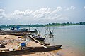 Cassava fermentation process by rural women and canoes at Oguta Lake.


Footnotes
- "Oguta Lake". Ramsar Sites Information Service. Retrieved 25 April 2018.
- Floyd, Barry (1969). Eastern Nigeria. Springer. p. 89. ISBN 9781349006663. Retrieved May 22, 2016.
- OGUNKOYA, Prof. O.O. (2007). "Oguta Lake" (PDF). Information Sheet on Ramsar Wetlands(RIS) (2006–2008): 4.
- akande, segun (2022-03-04). "Oguta Lake: In a corner of Imo, two angry rivers flow without ever coming together". Pulse Nigeria. Retrieved 2022-05-23.
- "Oguta Lake". www.ilec.or.jp. Retrieved 2008-06-08.
- Chuku, Gloria (2005). Igbo women and economic transformation in southeastern Nigeria, 1900-1960. Routledge. p. 26. ISBN 0-415-97210-8.
- "LakeNet -Lakes". www.worldlakes.org. Retrieved 2008-06-08.
External links
This Nigeria location article is a stub. You can help Wikipedia by expanding it. |
На других языках
[de] Oguta-See
Der Oguta-See ist der größte natürliche Binnensee im nigerianischen Bundesstaat Imo.- [en] Oguta Lake
Другой контент может иметь иную лицензию. Перед использованием материалов сайта WikiSort.org внимательно изучите правила лицензирования конкретных элементов наполнения сайта.
WikiSort.org - проект по пересортировке и дополнению контента Википедии