geo.wikisort.org - Reservoir
The Obersee near Simmerath in the borough of Aachen is the main forebay of the Rur Reservoir on the River Rur in the Eifel mountains of Germany. Its barrier is the Paulushofdamm. The reservoir, like that of the Rur Dam, belongs to the Eifel-Rur Water Company (Wasserverband Eifel-Rur). The reservoir provides drinking water.
| Obersee | |
|---|---|
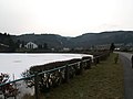
 The Obersee between Einruhr and Rurberg | |
| Location | Borough of Aachen, North Rhine-Westphalia (Germany) |
| Coordinates | 50.600°N 6.389°E |
| Construction began | ?–1959[1] |
| Dam and spillways | |
| Impounds | Rur, Urft |
| Height (foundation) | 33 m[1] |
| Height (thalweg) | 27 m[2] |
| Length | 280 m[1] |
| Elevation at crest | 283 m above sea level (NN)[1][3] |
| Width (crest) | 14.0 m[1] |
| Width (base) | 135 m[1] |
| Dam volume | 320,000 m3[1] |
| Reservoir | |
| Total capacity | 23 M m3[4] |
| Active capacity | 17.9 or 20.8 M m3[2] |
| Maximum length | – 4.8 Rur river km (nur Obersee)[5] – 5.15 Rur river km (Obersee and pre-dam)[5] – 13.4 km (to the head of the reservoir) |
| Normal elevation | 279.6 m above sea level (NN)[1][3] |


Location
The dam system, which comprises the Paulushofdamm and Obersee, lies in the Rur Eifel, a part of the North Eifel, southwest of the Kermeter, north of the Dreiborn Plateau and east of the Monschau Hedge Land near Simmerath (borough of Aachen). It is located immediately below the Urft Dam, which impounds the waters of the Urft that flow from the east to create the Urft Reservoir, and immediately above the Rur Dam which impounds the waters of the Rur to form the Rur Reservoir. While the dam belongs to the High Fens-Eifel Nature Park, the large eastern arm of the Obersee in the north lies within the Eifel National Park.
Photos
 The Paulushofdamm.
Behind: the pumpwork and broad-crested weir The weir and pumpwork on the Paulushofdamm
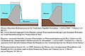 Diagram of the function of the weir in the Paulushofdamm
 The Obersee. its eastern arm was, like that of the Urft Reservoir, part of the former military training area at Vogelsang.
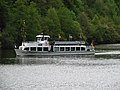 The passenger boat, Eifel, on the Obersee
 The swimming area, Naturerlebnisbad Einruhr, on the Obersee


See also
- List of dams in Germany
References
- "Die Rurtalsperre" (PDF; 1,65 MB). wver.de. Wasserverband Eifel-Rur (WVER). Retrieved 2016-05-07.[permanent dead link]
- unknown / unresearched source
- Hinweis zu Höhenangaben: "NHN-Höhe = NN-Höhe + 0,036 m";
siehe S. 2 → Fußzeile in Die Rurtalsperre[permanent dead link], Wasserverband Eifel-Rur (WVER), retrieved 7 May 2016, auf wver.de (PDF; 1,65 MB) - "Stauanlagenverzeichnis Nordrhein-Westfalen" (PDF; 121,1 KB). Landesamt für Natur, Umwelt und Verbraucherschutz Nordrhein-Westfalen-LANUV. 2005-10-20. Retrieved 2013-09-09.
- Topographic Information Management, Cologne - NRW GEObasis Division (info)
External links
- Pegeldaten: "Zeitreihenauswahl – Rurtalsperre Obersee Beckenpegel (Rurtalsperre)". wver.de. Wasserverband Eifel-Rur (WVER). Retrieved 2016-05-07.
Authority control | |
|---|---|
| General |
|
| National libraries | |
На других языках
[de] Obersee (Rur)
Der Obersee nahe Simmerath in der nordrhein-westfälischen Städteregion Aachen ist das Hauptvorbecken des an der Rur in der Eifel gelegenen Rurstausees (Rurtalsperre Schwammenauel). Sein Absperrbauwerk ist der Paulushofdamm. Die Stauanlage gehört, wie auch jene des Rurstausees, dem Wasserverband Eifel-Rur. Der Stausee dient unter anderem der Trinkwasserversorgung.- [en] Obersee (Rur)
Другой контент может иметь иную лицензию. Перед использованием материалов сайта WikiSort.org внимательно изучите правила лицензирования конкретных элементов наполнения сайта.
WikiSort.org - проект по пересортировке и дополнению контента Википедии