geo.wikisort.org - Reservoir
The Oahe Dam is a large earthen dam on the Missouri River, just north of Pierre, South Dakota, United States. The dam creates Lake Oahe, the fourth-largest man-made reservoir in the United States. The reservoir stretches 231 miles (372 km) up the course of the Missouri to Bismarck, North Dakota. The dam's power plant provides electricity for much of the north-central United States. It is named for the Oahe Indian Mission established among the Lakota Sioux in 1874.
| Oahe Dam | |
|---|---|
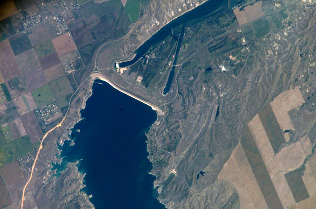
 Oahe powerhouse showing surge tanks and powerhouse, looking to north-west. | |
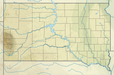 Location of Oahe Dam in South Dakota | |
| Location | Hughes/Stanley counties, South Dakota |
| Coordinates | 44°27′07″N 100°23′57″W |
| Construction began | 1948 |
| Opening date | 1962 |
| Construction cost | $340 Million |
| Operator(s) | |
| Dam and spillways | |
| Type of dam | Embankment, Rolled-earth fill & shale berms |
| Impounds | Missouri River |
| Height | 245 feet (75 m) |
| Length | 9,360 feet (2,850 m) |
| Width (base) | 3,500 feet (1,100 m) |
| Dam volume | 93,122,000 cubic yards (71,197,000 m3) |
| Spillways | 8 50-foot x 23.5-foot tainter gates |
| Spillway capacity | 304,000 cfs at 1,644.4 feet msl pool elevation |
| Reservoir | |
| Creates | Lake Oahe |
| Total capacity | 23,137,000 acre-feet (28.539 km3)[1] |
| Surface area | 374,000 acres (151,000 ha)[1] (max) |
| Power Station | |
| Commission date | April 1962–June 1963[1] |
| Turbines | 7x 112.29 MW |
| Installed capacity | 786 MW |
| Annual generation | 2,621 GWh[1] |
| Website U.S. Army Corps of Engineers - Oahe Project | |
The project provides flood control, hydropower generation, irrigation, and navigation benefits. Oahe Dam is one of six Missouri River mainstem dams, the next dam upstream is Garrison Dam, near Riverdale, North Dakota, and the next dam downstream is Big Bend Dam, near Fort Thompson, South Dakota.
South Dakota Highway 204 runs directly atop the Oahe Dam, providing an automobile crossing of the Missouri river at the dam.
History

In September and October 1804, the Lewis and Clark Expedition passed through what is now Lake Oahe while exploring the Missouri River.
The Oahe Dam was authorized by the Flood Control Act of 1944, and construction by the United States Army Corps of Engineers began in 1948. The world's first rock tunnel boring machine (TBM) was invented in 1952 by James S. Robbins for the Oahe Dam project,[2] which marked the beginning of machines replacing human tunnelers.[3] The earth main dam reached its full height in October 1959. It was officially dedicated by President John F. Kennedy on August 17, 1962, the year in which it began generating power. The original project cost was $340,000,000.
Statistics

- Dam height: 245 feet (75 m)
- Dam volume of earth fill: 92,000,000 cubic yards (70,000,000 m³)
- Dam volume of concrete: 1,122,000 cubic yards (858,000 m³)
- Spillway width: 456 feet (139 m)
- Spillway crest elevation: 1,596.5 feet (486.6 m)
- Lake maximum depth: 205 feet (62 m)
- Plant discharge 56,000 cubic feet per second (1,600 m3/s)
- Water speed through intake tunnels: 11 mph (5 m/s)
- Intake tunnel length: 3,650 feet (average) (1110 m)
- Number of turbines: 7, Francis type, 100 RPM
- Power generated per turbine: 112.29 MW
- reservoir storage capacity: 23,500,000 acre-feet (29.0 km3).
- States served with electricity: North Dakota, South Dakota, Nebraska, Minnesota and Montana
- Number of recreation areas around lake: 51
- Shore length: 2,250 miles (3,620 km)
- Counties bordering lake: 14, including 4 in North Dakota (Burleigh, Emmons, Morton, Sioux), and 10 in South Dakota (Campbell, Corson, Dewey, Haakon, Hughes, Potter, Stanley, Sully, Walworth, and Ziebach)
Tours
Tours of the powerplant are given daily, Memorial Day through Labor Day.[4]
Native American displacement
As a result of the dam's construction the Cheyenne River Indian Reservation lost 150,000 acres (61,000 hectares) bringing it down to 2,850,000 acres (1,150,000 ha) today. Standing Rock Reservation lost 55,993 acres (22,660 ha) leaving it with 2,300,000 acres (930,000 ha). Much of the land was taken by eminent domain claims made by the Bureau of Reclamation. Over and above the land loss, most of the reservations' prime agricultural land was included in the loss. The regions where the populations were resettled had soil with a higher clay content, and resources such as medicinal plants were less prevalent.[5]
The loss of this land had a dramatic effect on the Natives who lived on the reservations. Most of the land was unable to be harvested (to allow the trees to be cut down for wood, etc.) before the land was flooded over with water.[6] One visitor to the reservations later asked why there were so few older Natives on the reservations and was told that "the old people had died of heartache" after the construction of the dam and the loss of the reservations' land.[7] As of 2015, poverty remains a problem for the displaced populations in the Dakotas, who are still seeking compensation for the loss of the towns submerged under Lake Oahe, and the loss of their traditional ways of life.[8]
Huff Archeological Site is a fortified Mandan village site on what is now the bank of Lake Oahe. It is designated a National Historic Landmark, but is endangered by erosion pressure from the lake.
2011 flooding

Excessive precipitation in the spring, along with melting snow from the Rocky Mountains forced the dam to open the release gates (not the spillway), releasing 110,000 cu ft/s (3,115 m3/s) in June with another 50,000 cu ft/s (1,416 m3/s) through the power plant totaling 160,000 cu ft/s (4,531 m3/s).[9] The previous release record was 53,900 cu ft/s (1,526 m3/s) in 1997.
See also
- Keystone Pipeline
- List of reservoirs and dams in the United States
Notes
- "Summary of Engineering Data – Missouri River Main Stem System" (PDF). Missouri River Division. U.S. Army Corps of Engineers. August 2010. Retrieved August 17, 2012.
- "Robbins celebrates 60 years of achievement". TunnelTalk.com. October 2012.
- Wall Street Journal, 4/25/2016, p.R3
- "Oahe Project Resumes Powerhouse Tours; Visitor Center Summer Hours Set". Omaha District. Retrieved September 24, 2022.
- Allard, LaDonna Brave Bull (September 3, 2016). "Interview with LaDonna Brave Bull Allard, Standing Rock Sioux tribal historian, on the 153rd anniversary of the Whitestone massacre". Democracy Now! (video). Interviewed by Amy Goodman. Event occurs at 42:26. Archived from the original on September 10, 2016. Retrieved September 11, 2016. (transcript)
- Carrels, Peter (1999). Uphill Against Water. University of Nebraska Press. ISBN 0-8032-6397-X.
- "The Natives Are Getting Uppity". Ilze Choi. dickshovel.com. Retrieved April 5, 2009.
- Lee, Trymaine. "No Man's Land: The Last Tribes of the Plains. As industry closes in, Native Americans fight for dignity and natural resources". MSNBC - Geography of Poverty Northwest. Retrieved September 28, 2015.
- Associated Press (June 7, 2011). "Oahe Dam Releases Water With Rumbling Force". Retrieved June 7, 2011.
References
- Lawson, Michael L. Dammed Indians: the Pick-Sloan Plan and the Missouri River Sioux, 1944–1980. Norman: University of Oklahoma Press, 1982. ISBN 0-8061-2672-8
- Lazarus, Edward. Black Hills, White Justice: The Sioux Nation Versus the United States, 1775 to the Present. New York: Harper Collins, 1991. ISBN 0-06-016557-X.
- Cornell University site
- U.S. Army Corps of Engineers pamphlet "Oahe Power Plant", no date
- Summary of Engineering Data – Missouri River Main Stem System http://www.nwd-mr.usace.army.mil/rcc/projdata/summaryengdat.pdf
External links
- U.S. Army Corps of Engineers - Oahe Project
- Daily Reservoir Water Levels and Water Releases Information (U.S. Army Corps of Engineers)
Dams on the Missouri River | ||
|---|---|---|
 | ||
Authority control | |
|---|---|
| General | |
| National libraries | |
На других языках
[de] Lake Oahe
Der Lake Oahe, der vom Oahe-Staudamm aufgestaut wird, ist eine der größten Talsperren am Missouri River im Norden von Pierre, South Dakota, USA. Der See, der sich 372 km den Verlauf des Missouri entlang bis Bismarck in North Dakota zieht, ist gemessen an der Wasseroberfläche der drittgrößte Stausee in den USA, nach dem Speicherraum (für den es die Angaben 27.400 oder 28.776 oder 29.093 Millionen m³ gibt) der dritt- oder viertgrößte.- [en] Oahe Dam
[es] Presa y lago Oahe
La presa de Oahe (en inglés: Oahe Dam) se encuentra en el río Misuri y forma el lago Oahe, el cuarto embalse artificial en tamaño del país, que se extiende a lo largo de 231 km corriente arriba del Misuri hasta Bismarck (Dakota del Norte). Se encuentra en los condados de Hughes y Stanley, en Dakota del Sur, Estados Unidos de América. Queda justo al norte de Pierre (Dakota del Sur). La central hidroeléctrica de la presa proporciona electricidad para gran parte de los Estados Unidos centro-septentrionales. Recibe su nombre de la misión india de Oahe creada entre los siux lakota en 1874. El proyecto proporciona control frente a las inundaciones, energía eléctrica, irrigación y beneficios para la navegación, calculados por el Cuerpo de Ingenieros en 150 millones de dólares al año.[ru] Плотина Оахе
Дамба Оахе — крупная ГЭС на реке Миссури, к северу от Пирра . Плотиной ГЭС образовано крупное озеро (водохранилище) Оахе, начинается близ Бисмарка и заканчивается близ Пирра — это четвёртое по величине водохранилище в Соединенных Штатах (длина 372 км). Силовая установка дамбы обеспечивает электричество штатам Северная Дакота, Южная Дакота, Небраска, Миннесота и Монтана. Плотина обеспечивает борьбу с наводнениями, электроэнергию, ирригацию, и навигацию.Другой контент может иметь иную лицензию. Перед использованием материалов сайта WikiSort.org внимательно изучите правила лицензирования конкретных элементов наполнения сайта.
WikiSort.org - проект по пересортировке и дополнению контента Википедии