geo.wikisort.org - Reservoir
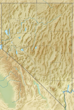
North Furlong Lake is a glacial tarn in the Ruby Mountains, in Elko County in the northeastern part of the state of Nevada.[1] It is located at the head of North Furlong Canyon at approximately 40°33.4′N 115°24.8′W, and at an elevation of 9590 feet (2920 meters). It has an area of approximately 16 acres (6.5 hectares), and a depth of up to 20 feet (6 meters). This is a common camp for users of the Ruby Crest National Recreation Trail, which passes nearby.
| North Furlong Lake | |
|---|---|
 | |
 North Furlong Lake Location in Nevada | |
| Location | Ruby Mountains, Elko County, Nevada |
| Coordinates | 40°33′24″N 115°24′48″W |
| Type | tarn |
| Basin countries | United States |
| Surface area | 16 acres (6.5 ha) |
| Max. depth | 20 ft (6.1 m) |
| Surface elevation | 9,590 ft (2,920 m) |
North Furlong Lake is the primary source of North Furlong Creek, which after exiting the mountains merges with other streams to form the South Fork of the Humboldt River.
References
Текст в блоке "Читать" взят с сайта "Википедия" и доступен по лицензии Creative Commons Attribution-ShareAlike; в отдельных случаях могут действовать дополнительные условия.
Другой контент может иметь иную лицензию. Перед использованием материалов сайта WikiSort.org внимательно изучите правила лицензирования конкретных элементов наполнения сайта.
Другой контент может иметь иную лицензию. Перед использованием материалов сайта WikiSort.org внимательно изучите правила лицензирования конкретных элементов наполнения сайта.
2019-2025
WikiSort.org - проект по пересортировке и дополнению контента Википедии
WikiSort.org - проект по пересортировке и дополнению контента Википедии