geo.wikisort.org - Reservoir
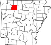
There are at least 9 named lakes and reservoirs in Newton County, Arkansas.
Lakes
According to the United States Geological Survey, there are no named lakes in Newton County, Arkansas.
Reservoirs
- Edwards Lake, 36°06′54″N 093°12′25″W, el. 1,086 feet (331 m) [1]
- Fowler Lake, 35°57′13″N 093°24′58″W, el. 2,106 feet (642 m) [2]
- Hurricane Lake, 35°54′15″N 092°57′51″W, el. 997 feet (304 m) [3]
- Lower Hurricane Lake, 35°55′35″N 092°57′48″W, el. 902 feet (275 m) [4]
- Mill Creek Hollow Reservoir, 36°04′30″N 093°08′13″W, el. 820 feet (250 m) [5]
- North Pond, 36°03′18″N 093°10′48″W, el. 866 feet (264 m) [6]
- South Pond, 36°03′12″N 093°10′43″W, el. 846 feet (258 m) [7]
- Sycamore Lake, 35°55′35″N 092°57′48″W, el. 902 feet (275 m) [8]
- Weatherby Lake, 36°01′49″N 093°14′31″W, el. 2,096 feet (639 m) [9]
See also
- List of lakes in Arkansas
Notes
- "Edwards Lake". Geographic Names Information System. United States Geological Survey, United States Department of the Interior.
- "Fowler Lake". Geographic Names Information System. United States Geological Survey, United States Department of the Interior.
- "Hurricane Lake". Geographic Names Information System. United States Geological Survey, United States Department of the Interior.
- "Lower Hurricane Lake". Geographic Names Information System. United States Geological Survey, United States Department of the Interior.
- "Mill Creek Hollow Reservoir". Geographic Names Information System. United States Geological Survey, United States Department of the Interior.
- "North Pond". Geographic Names Information System. United States Geological Survey, United States Department of the Interior.
- "South Pond". Geographic Names Information System. United States Geological Survey, United States Department of the Interior.
- "Sycamore Lake". Geographic Names Information System. United States Geological Survey, United States Department of the Interior.
- "Weatherby Lake". Geographic Names Information System. United States Geological Survey, United States Department of the Interior.
Текст в блоке "Читать" взят с сайта "Википедия" и доступен по лицензии Creative Commons Attribution-ShareAlike; в отдельных случаях могут действовать дополнительные условия.
Другой контент может иметь иную лицензию. Перед использованием материалов сайта WikiSort.org внимательно изучите правила лицензирования конкретных элементов наполнения сайта.
Другой контент может иметь иную лицензию. Перед использованием материалов сайта WikiSort.org внимательно изучите правила лицензирования конкретных элементов наполнения сайта.
2019-2025
WikiSort.org - проект по пересортировке и дополнению контента Википедии
WikiSort.org - проект по пересортировке и дополнению контента Википедии
