geo.wikisort.org - Reservoir
The Leibis-Lichte Dam (German: Talsperre Leibis –Lichte) is a 102.5-metre-tall (336 ft) dam in the German state of Thuringia in the Thuringian Highland. The dam was completed in 2005 to impound the River Lichte, between the Lichte municipality section Geiersthal and Unterweissbach. To that particular storage reservoir belongs the Deesbach Forebay (German: Vorsperre Deesbach). The name of the dam, "Leibis-Lichte Dam" was derived from the close proximity to the municipalities of Leibis and Lichte, as well as from the Lichte River as being the main inlet.
| Leibis-Lichte Dam | |
|---|---|
 View of dam from the west | |
| Country | Germany Thuringia |
| Location | Distr. Saalfeld-Rudolstadt, Municip. Unterweissbach, Lichte Valley |
| Coordinates | 50°36′3″N 11°10′24″E |
| Construction began | 2002 |
| Opening date | 2005 |
| Dam and spillways | |
| Type of dam | Gravity dam |
| Height | 102.5 m (336 ft) |
| Length | 369 m (1,211 ft) |
| Width (crest) | 9 metres (30 ft) |
| Width (base) | 80.6 m (264 ft) |
| Dam volume | 13,500 m3 (480,000 cu ft) |
| Spillway capacity | 86.5 cubic metres per second (3,054.7 cu ft/s) |
| Reservoir | |
| Creates | 5.6 million cubic metres (0.198×10⁹ cu ft) |
| Total capacity | 32.4 million cubic metres (1.14×10⁹ cu ft) |
| Catchment area | 72 square kilometres (28 sq mi) |
| Surface area | 122 hectares (301 acres) |
| Maximum water depth | 91 metres (299 ft) |
| Power Station | |
| Installed capacity | 1 megawatt (1,300 hp) |
Construction
The Leibis-Lichte Dam was constructed in the time period from 2002 to September 2005.

Inside the formwork, heavy equipment was used to spread and compact the large quantities of concrete.[1] Mini excavators and graders put nearly 2,000 cubic metres (71,000 cu ft) of concrete each day into the formwork blocks. Giant cable cranes, reaching over the valley, moved the concrete across the site, with the transport containers holding up to 6 cubic metres (212 cu ft) of concrete.[1]

Pictures
 Leibis-Lichte Dam, 102.5 m high (336 ft)
 Office building on top of the dam
 View from the dam to the artificial lake, August 2009
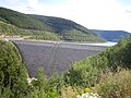 Dam completed, August 2009
 View from inside the waterside


See also
- List of reservoirs and dams in Germany
References
- "Bickhardt Bau AG - Drinking Water for Thüringa", Bickhardt-bau.de, 2010, webpage: BH421.
External links
![]() Media related to Talsperre Leibis-Lichte at Wikimedia Commons
Media related to Talsperre Leibis-Lichte at Wikimedia Commons
- Leibis-Lichte Dam on homepage of the Thuringian long-distance water supply (de: Tueringer Fernwasserversorgung
- Homepage (private) concerning the Leibis-Lichte Dam
- Pictures of the building site on baustellen-doku.info
Authority control | |
|---|---|
| General |
|
| National libraries | |
На других языках
[de] Talsperre Leibis-Lichte
Die Talsperre Leibis-Lichte (auch: Leibis/Lichte) ist eine Talsperre im Freistaat Thüringen. Sie liegt nahe Unterweißbach im Lichtetal im Thüringer Schiefergebirge. Ihren Namen hat sie von dem Ort Leibis, dessen 100 Bewohner in den Ort Neu-Leibis umgesiedelt wurden, und dem gestauten Gewässer Lichte, einem Zufluss der Schwarza. Sie dient der Trinkwasserversorgung Ostthüringens und dem Hochwasserschutz. Nachdem mit der Flutung bereits im Februar 2005 begonnen wurde, fand die offizielle Einweihung am 12. Mai 2006 statt. Die Flutung fand bis Mitte 2008 statt. Es ist eine tägliche Entnahme von 43.700 m³ Rohwasser vorgesehen. Der Talsperre ist die Vorsperre Deesbach vorgelagert.- [en] Leibis-Lichte Dam
Другой контент может иметь иную лицензию. Перед использованием материалов сайта WikiSort.org внимательно изучите правила лицензирования конкретных элементов наполнения сайта.
WikiSort.org - проект по пересортировке и дополнению контента Википедии