geo.wikisort.org - Reservoir
Lake Saint-Louis is a lake in southwestern Quebec, Canada, at the confluence of the Saint Lawrence and Ottawa Rivers. The Saint Lawrence Seaway passes through the lake.
| Lake Saint-Louis Lac Saint-Louis (French) | |
|---|---|
 Lake St. Louis at St-Anne-de-Bellevue looking towards Île Perrot | |
 Lake Saint-Louis Lac Saint-Louis (French) | |
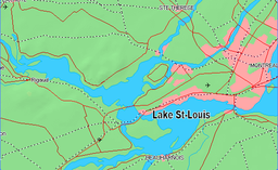 Location map | |
| Location | Montérégie region, southwestern Quebec |
| Coordinates | 45°24′05″N 73°48′51″W |
| Type | Natural |
| Primary inflows | Beauharnois Canal, Saint Lawrence River, Ottawa River, Saint-Charles River |
| Primary outflows | Saint Lawrence River |
| Basin countries | Canada |
| Surface elevation | 21 m (69 ft) |
| Settlements | Montreal |
Lake St. Louis is a widening of the St. Lawrence River in the Hochelaga Archipelago. It is also fed by the Ottawa River via the Lake of Two Mountains at Sainte-Anne-de-Bellevue, the Beauharnois Canal, the Soulanges Canal, the Saint-Louis River, and the Châteauguay River.
The lake is bounded to the north and the east by the Island of Montreal, by Beauharnois-Salaberry, Roussillon, and Vaudreuil-Soulanges. The town of Beauharnois with its power-dam and canal lie to the south.
The West Island shore is mostly built up with private houses, but it includes some parks and clubs such as the Pointe-Claire Canoe Club, and the Pointe-Claire Yacht Club. Islands in the lake include Dorval and Dowker Islands. Lake St. Louis is the second of three fluvial lakes on the St. Lawrence River; upstream of it is Lake Saint Francis, and downstream is Lake Saint Pierre. Lake St. Louis has an average flow of 8,400 cubic metres per second (300,000 cu ft/s).[1]
The lake has many species of fish, including yellow perch.
A small map by Samuel Champlain of 1611 names the lake. The same year, Champlain reported that a young man named Louys was drowned in what is now known as the Lachine Rapids, and in 1870 Charles-Honoré Laverdière stated that the rapids, and later the lake, were named in honour of the drowned man. A 1656 Jesuit account describes a crossing «Lac Saint Louys».[2]
In 2014 there was a report of fecal coliform flowing into the lake from a Beaconsfield creek,[3] and of PCBs flowing into it from a Pointe-Claire industrial site.[4]
References
- Environment Canada - fluvial lakes of the St. Lawrence Archived 2014-07-08 at the Wayback Machine
- "Lac Saint-Louis". Commission de toponymie. Retrieved 25 June 2014.
- "Beaconsfield residents had no idea backyard creek was polluted with fecal coliform". www.cbc.ca. Retrieved 2016-04-09.
- "Pointe-Claire pays $435,000 cleanup bill at PCB site on Hymus". Montreal Gazette. Retrieved 2016-04-09.
На других языках
[de] Lac Saint-Louis
Der Lac Saint-Louis ist ein 148 km² großer See im Südwesten der kanadischen Provinz Québec. Er befindet sich südwestlich von Montreal im Bereich der Mündung des Ottawa in den Sankt-Lorenz-Strom und gehört zum Hochelaga-Archipel.- [en] Lake Saint-Louis
[fr] Lac Saint-Louis
Le lac Saint-Louis est un élargissement du fleuve Saint-Laurent situé dans le sud-ouest du Québec (Canada), au sud de l'île de Montréal. Les îles qui s'y trouvent font partie de l'archipel d'Hochelaga, telle l'île Dorval et la réserve nationale de faune des îles de la Paix[1]. Le lac est au confluent du fleuve et de la rivière des Outaouais.[it] Lago Saint-Louis
Lago Saint-Louis (in francese Lac Saint-Louis) è un lago nel Quebec sud-occidentale, in Canada, adiacente all'isola di Montreal.Другой контент может иметь иную лицензию. Перед использованием материалов сайта WikiSort.org внимательно изучите правила лицензирования конкретных элементов наполнения сайта.
WikiSort.org - проект по пересортировке и дополнению контента Википедии