 Mount Scott observation view of Lake Lawtonka
 Mount Scott observation view of School House Slough Marina at Lake Lawtonka
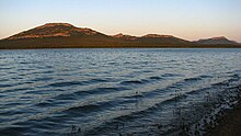 Mount Scott and Lake Lawtonka view from Robinson's Landing Marina
geo.wikisort.org - Reservoir
Lake Lawtonka is a lake in Comanche County in the state of Oklahoma in the United States.[4][5] The lake is 2 square miles (5 km2) in area. It is formed by a dam 60 feet (18 m) and 375 feet (114 m) long across Medicine Creek.[6][7]
| Lake Lawtonka | |
|---|---|
 East shore of Lake Lawtonka at sunset, with Canada geese. Mount Scott in background. Photo by Schyler, August 1, 2011. | |
 Lake Lawtonka  Lake Lawtonka | |
| Location | Comanche County, Oklahoma |
| Coordinates | 34.7559°N 98.5041°W |
| Type | reservoir |
| Primary inflows | Medicine Creek |
| Primary outflows | Medicine Creek |
| Catchment area | 92 sq mi (240 km2) |
| Basin countries | |
| Managing agency | City of Lawton |
| Built | 1905 |
| Surface area | 2,325 acres (941 ha) |
| Average depth | 23.6 ft (7.2 m) |
| Max. depth | 58.4 ft (17.8 m) |
| Water volume | 63,000 acre⋅ft (0.078 km3) |
| Shore length1 | 19.2 mi (30.9 km) |
| Surface elevation | 1,345.55 ft (410.12 m) |
| Settlements | Lawton, Medicine Park, Meers |
| References | [1][2][3] |
| 1 Shore length is not a well-defined measure. | |
The lake provides the water supply for the Fort Sill and Lawton communities as situated south of the water reservoir.[5] The town of Medicine Park is south of the lake and provides a visual of the Lawtonka dam. Lawtonka Acres and Robinson's Landing Marina are located at the north shoreline boundaries of the Lawtonka recreation area.
Recreation
Fishing and camping facilities are maintained by the city of Lawton.[8][9]
Landscape Pictorial
Lake Lawtonka and Wichita Mountains


See also
- Cache Creek (Oklahoma)
- Mount Scott (Oklahoma)
- Wichita Mountains
- Wichita Mountains Wildlife Refuge
References
- Oklahoma Water Resource Board. "Hydrographical Survey of Lake Lawtonka (2006)" (pdf). Retrieved 2010-05-15.
- "Lake Lawtonka" (pdf). Oklahoma Water Resources Board ~ Beneficial Use Monitoring Program (BUMP). Oklahoma State Portal ~ OK.gov. Retrieved 2012-10-21.
- "Lake Lawtonka Map". Oklahoma Water Resources Board ~ Lakes Of Oklahoma. Oklahoma State Portal ~ OK.gov. Retrieved 2012-10-21.
- U.S. Geological Survey Geographic Names Information System: Lake Lawtonka
- Merriam-Webster's Geographical Dictionary, Third Edition, p. 636.
- U.S. Geological Survey Geographic Names Information System: Medicine Creek
- U.S. Geological Survey Geographic Names Information System: Medicine Bluffs
- "City of Lawton Lakes Division". City of Lawton Departments. City of Lawton.
- Lawton Boating-Fishing-Camping-Swimming-Hunting Regulations Archived 2007-10-17 at the Wayback Machine
External links
 Media related to Lake Lawtonka at Wikimedia Commons
- Johnson, Kenneth S. (2009). "Lakes and Reservoirs". Encyclopedia of Oklahoma History and Culture. Oklahoma Historical Society. Retrieved September 12, 2015.
- Johnson, Kenneth S. (2009). "Rivers and Streams". Encyclopedia of Oklahoma History and Culture. Oklahoma Historical Society. Retrieved October 13, 2012.
- Johnson, Kenneth S.; Luza, Kenneth V. (2008). "Rivers, Streams, and Lakes of Oklahoma" (PDF). Oklahoma Geological Survey. University of Oklahoma. Retrieved October 13, 2012.
- Merriam-Webster's Geographical Dictionary, Third Edition. Springfield, Massachusetts: Merriam-Webster, Incorporated, 1997. ISBN 0-87779-546-0.
- Oklahoma Digital Maps: Digital Collections of Oklahoma and Indian Territory
Текст в блоке "Читать" взят с сайта "Википедия" и доступен по лицензии Creative Commons Attribution-ShareAlike; в отдельных случаях могут действовать дополнительные условия.
Другой контент может иметь иную лицензию. Перед использованием материалов сайта WikiSort.org внимательно изучите правила лицензирования конкретных элементов наполнения сайта.
Другой контент может иметь иную лицензию. Перед использованием материалов сайта WikiSort.org внимательно изучите правила лицензирования конкретных элементов наполнения сайта.
2019-2026
WikiSort.org - проект по пересортировке и дополнению контента Википедии
WikiSort.org - проект по пересортировке и дополнению контента Википедии