geo.wikisort.org - Reservoir
Lake Kerkini (Greek: Λίμνη Κερκίνη - Limni Kerkini) is an artificial reservoir in Central Macedonia, Greece that was created in 1932, and then redeveloped in 1980, on the site of what was previously an extremely extensive marshland.
| Lake Kerkini | |
|---|---|
 | |
 Lake Kerkini | |
| Coordinates | 41.21°N 23.13°E |
| Type | reservoir |
| Primary inflows | Strymon River |
| Primary outflows | Strymon River |
| Basin countries | Greece |
| Max. length | 17 kilometers (11 mi) |
| Max. width | 5 kilometers (3.1 mi) |
| Surface area | 75 square kilometers (29 sq mi) |
| Max. depth | 35.5 m (116 ft) |
| Surface elevation | 35 meters (115 ft) |
Ramsar Wetland | |
| Official name | Artificial Lake Kerkini |
| Designated | 21 August 1975 |
| Reference no. | 58[1] |

Lake Kerkini is now one of the premier birdwatching sites in Greece, as it is situated along the migratory flyway for birds en route to the Aegean Sea, the Balkan region, the Black Sea, the Hungarian steppes and beyond.
History
Before 1932, there were irregular marsh lakes on Strymon, one of them called "Podkova" (in Bulgarian and Slavic Macedonian "Podkova" meaning "Horseshoe", found in Ottoman Turkish records: ݒودقوه كولي Podkova Gölü.[2]).
Kerkini lake was created by making embankments on the eastern and western sides of the river and by a dam constructed near the village of Lithotopos, which started functioning in 1932.
As time went by, the lake's capacity was reduced due to silt deposited by Strymon river. So the raising of the embankments and the construction of a new dam was necessary, which started operating in 1982.
Geography
The lake's main water source is the Strymon River, although it is also fed by the Kerkinitis river from Krousia.
The lake's surrounding area is flat and semi-mountainous. The lake's size varies from 54 km2 to 72 km2.
The lake is a technical work of great agricultural utility and provides a hydrobiosphere for thousands of water fowls.
Nature
This biosphere is recouped by the International Convention of Ramsar and presents numerous admirable elements. Thousands of birds, both rare and protected, riverside forests, water-lilies in a large area, fish variety and fantastic panoramic view from the mountains of Belasica and Krousia give it a characteristic tone. Actually the lake hosts 227 kinds of birds, especially non-migrants, of which 76 are recorded in the National Red Catalogue, while at least 31 of them are protected by EEC's Directive concerning wild life. What makes an exceptional presence is the buffalo's herd in the area, plus the one of the jackelo in the area of Lake Kerkini. In the surrounding area of Lake Kerkini there are at least 10 amphibian species (frogs, salamanders, newts, five snail species, 19 reptile species (lizards, snakes, turtles) and a great variety of insects which play an important part in the food chain and contribute towards the biological resources of the lake.
The human intervention usually retracts or takes negative action against the natural processes. Lake Kerkini is a rare example, where the gentle human handling has had the exact opposite result.
Gallery
 Krousia mount from the lake
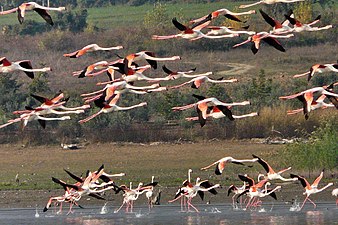 Flamingos in the lake
 White pelicans at the lake
 Buffalos at the lake
 View
View View
View The dam of Lake Kerkini
 Small boat on the lake


References
- "Artificial Lake Kerkini". Ramsar Sites Information Service. Retrieved 25 April 2018.
- "Harvard Mirador Viewer".
External links
На других языках
[de] Kerkini-See
Der Kerkini-See (griechisch Λίμνη Κερκίνη, bulgarisch Бутковско езеро) ist der drittgrößte Stausee Griechenlands.- [en] Lake Kerkini
[it] Kerkini (lago)
Il lago Kerkini (in greco: Λίμνη Κερκίνη, traslitterato: Limnī Kerkinī) è un lago artificiale nella Macedonia Centrale, Grecia. Costruito nel 1932, nel 1980 terminarono i lavori di riqualificazione, sul sito di quella che prima era una palude estremamente estesa.[ru] Керкини
Керки́ни[1] (греч. Λίμνη Κερκίνη) — водохранилище в северной Греции, на северо-западе периферийной единицы Сере в периферии Центральная Македония. Лежит в 47 километрах от греческо-болгарской границы; в 20 километрах к юго-западу расположен административный центр периферийной единицы Сере, в 10 километрах к востоку — город Сидирокастрон. Водохранилище было образовано на реке Стримонас в 1932 году для ирригации и предотвращения наводнений, гидротехнические работы в 1983 и 1987 годах его увеличили. Площадь его зеркала составляет 109,96 км²[2], а площадь водосборного бассейна — около 11 520 км²[2]. Территория водохранилища является рамсарским угодьем, ключевой орнитологической территорией и входит вместе с горой Крусия (Мавровуни) в сеть природоохранных зон «Натура 2000»[3][2][4].Другой контент может иметь иную лицензию. Перед использованием материалов сайта WikiSort.org внимательно изучите правила лицензирования конкретных элементов наполнения сайта.
WikiSort.org - проект по пересортировке и дополнению контента Википедии