geo.wikisort.org - Reservoir
Lake Izabal (Spanish pronunciation: [isaˈβal]), also known as the Golfo Dulce, is the largest lake in Guatemala with a surface area of 589.6 km² (145,693 acres or 227.6 sq mi) and a maximum depth is 18 m (59 ft). The Polochic River is the largest river that drains into the lake. The lake, which is only a metre above sea level, drains into the Gulf of Honduras of the Caribbean Sea through the smaller Golfete Dulce, which is at sea level, and the navigable Rio Dulce.
| Lake Izabal | |
|---|---|
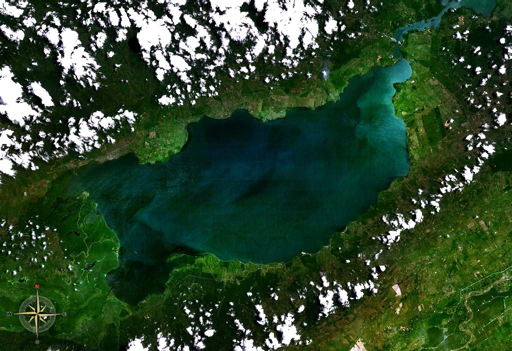 from space | |
 Lake Izabal | |
| Coordinates | 15.5°N 89.1667°W |
| Primary inflows | Polochic River |
| Primary outflows | Río Dulce |
| Basin countries | Guatemala |
| Surface area | 589.6 km2 (227.6 sq mi)[1] |
| Max. depth | 18 m (59 ft) |
| Surface elevation | 1 m (3 ft) |
| References | [1] |
The well preserved colonial Castillo de San Felipe de Lara guarded this lake against pirate attacks, and there are some ancient sunken ships nearby. It is home to several species including the Manatee, Jaguar, Spider Monkey, Blue-eye cichlids, and Howler Monkey, and is a popular place for birdwatching.
Culture
There are many indigenous communities surrounding the lake, namely the Mayas Q'eqchi'.
The Castle of San Felipe de Lara, constructed in 1652 in honor of Judge Antonio Lara Mangravo, was built to protect the region from pirates.
References
- INSIVUMEH. "Indice de lagos". Retrieved 13 July 2008.
External links
- Instituto Nacional de Sismología, Vulcanología, Meteorología e Hidrolagía (INSIVUMEH)
- Lakes in Guatemala Photo gallery
- Lake description (in Spanish)
- Guatemalan Fauna Photo gallery
Authority control | |
|---|---|
| General | |
| National libraries | |
This Guatemala location article is a stub. You can help Wikipedia by expanding it. |
На других языках
[de] Izabal-See
Der Izabal-See (spanisch Lago de Izabal, früher auch Golfo Dulce) ist der größte See Guatemalas. Der 48 km lange und an seiner breitesten Stelle bis zu 20 km breite See liegt in der Nähe des karibischen Meeres, mit der er durch den Río Dulce verbunden ist, dessen Mündung sich direkt an der Südseite von Livingston befindet.- [en] Lake Izabal
[es] Lago de Izabal
El lago de Izabal, también conocido como golfo Dulce, es un lago que se encuentra en el departamento de Izabal, cerca de la costa del Mar Caribe de Guatemala. Es el mayor de dicho país: mide 45 km de largo por 20 km de ancho, con un área total de 589,6 km². Drena en el Mar Caribe a través de un lago más pequeño, el golfete Dulce, y el río Dulce.[fr] Lac Izabal
Le Lac Izabal (Lago de Izabal, également connu comme Golfo Dulce), est le plus grand lac du Guatemala. Il est situé à une trentaine de kilomètres de la mer des Caraïbes dans laquelle il se jette au travers du Rio Dulce. Il a donné son nom au département d'Izabal.[ru] Исабаль (озеро)
Исабаль (исп. Lago de Izabal) — озеро в восточной Гватемале (департамент Исабаль).Другой контент может иметь иную лицензию. Перед использованием материалов сайта WikiSort.org внимательно изучите правила лицензирования конкретных элементов наполнения сайта.
WikiSort.org - проект по пересортировке и дополнению контента Википедии