geo.wikisort.org - Reservoir
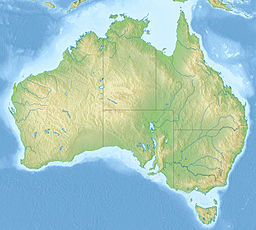
Lake Buchanan is a flat salt lake at Pentland in North Queensland, Australia. It is approximately 28 km long and 8 km wide at its widest point, with a surface area of about 117 km2. It is part of the Thomson River catchment and part of the Desert Uplands bioregion.[1][2]
| Lake Buchanan | |
|---|---|
 World Wind image of Lake Buchanan, 2010. | |
| Location | 163 km South West of Charters Towers, Queensland |
| Coordinates | 21.5324°S 145.849°E |
| Type | Salt lake |
| Catchment area | Thomson River |
| Basin countries | Australia |
| Max. length | 21 km (13 mi) |
| Max. width | 8 km (5.0 mi) |
| Surface area | 117 km2 (45 sq mi)[1] |
Lake Buchanan is different from all other salt lakes in Australia because it occurs at a high elevation - on the Great Dividing Range. The lake is shallow and the water tends to be brackish.[1] The land around the lake is used for grazing.[1]
Lake Buchanan contains a number of significant species which are newly discovered and most probably endemic.[2] These include the Lake Buchanan button grass, fringing rush, Lake Buchanan fringe rush, Lawrenica buchananensis (Malvaceae), and Buchanan's fairy shrimp. The Lake Buchanan blue bush is a threatened species belonging to the genus Chenopodium.
See also
- Lake Galilee
- List of lakes of Australia
References
- (5 April 2011). Site Investment Guide: Lake Buchanan Archived 2011-06-01 at the Wayback Machine. Australian Government Land and Coasts. Retrieved on 12 July 2011.
- Sue Gardner (April 2010). "Arid and Semi-arid Lakes" (PDF). Queensland Wetlands Program. Archived from the original (PDF) on 6 July 2011. Retrieved 12 July 2011.
На других языках
[de] Lake Buchanan (Queensland)
Der Lake Buchanan ist ein flacher Salzsee im Pentland im nördlichen Queensland von Australien. Er liegt im Barkly Tableland. Er ist ungefähr 28 km lang und an der breitesten Stelle 8 km breit mit insgesamt 117 km² Fläche. Er gehört zum Einzugsgebiet des Thomson River und ist Teil der Desert Uplands Bioregion. Der See unterscheidet sich von allen anderen Salzseen Australiens dadurch, dass er sehr hoch liegt, im Great Dividing Range. Er ist nicht sehr tief und das Wasser leicht salzhaltig. Um den See herum gibt es Grasland. Im Schnitt fällt im Jahr 60 mm Regen. Der See wurde nach dem Entdecker Nathaniel Buchanan benannt.- [en] Lake Buchanan (Queensland)
Другой контент может иметь иную лицензию. Перед использованием материалов сайта WikiSort.org внимательно изучите правила лицензирования конкретных элементов наполнения сайта.
WikiSort.org - проект по пересортировке и дополнению контента Википедии

