geo.wikisort.org - Reservoir
Lake Bolon (Russian: Болонь) is a large freshwater lake in the Khabarovsk Krai, Russia. It has an area of 338 km²; it is 70 km long and 20 km wide, and has a maximum depth of about 4 m. It is located on the broad west-bank flood plain of the Amur River about 80 km south of Komsomolsk and drains into the Amur by a 9 km channel. Lake Bolon is an important stopping place for migratory birds. The south end of the lake is a nature preserve.[2]
This article needs additional citations for verification. (February 2010) |
| Lake Bolon | |
|---|---|
 from space | |
 Lake Bolon 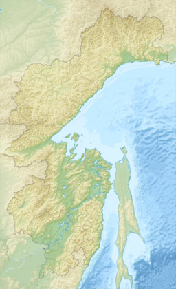 Lake Bolon | |
| Location | Khabarovsk Krai, Russia |
| Coordinates | 49.8°N 136.3666667°E |
| Type | Floodplain lake |
| Basin countries | Russia |
| Max. length | 70 km (43 mi) |
| Max. width | 20 km (12 mi) |
| Surface area | 338 km2 (131 sq mi) |
| Max. depth | 4 m (13 ft) |
Ramsar Wetland | |
| Official name | Lake Bolon and the mouths of the Selgon and Simmi Rivers |
| Designated | 13 September 1994 |
| Reference no. | 686[1] |
References
Wikimedia Commons has media related to Lake Bolon.
- "Lake Bolon and the mouths of the Selgon and Simmi Rivers". Ramsar Sites Information Service. Retrieved 25 April 2018.
- "22. Information Sheet on Ramsar Wetlands" Archived 2011-06-22 at the Wayback Machine. Wetlands International. Retrieved 25 January 2010.
This Khabarovsk Krai location article is a stub. You can help Wikipedia by expanding it. |
На других языках
- [en] Lake Bolon
[it] Lago Bolon'
Il lago Bolon' (in russo: озеро Болонь?) è un lago d'acqua dolce dell'Estremo Oriente russo nel bacino del fiume Amur. Scorre nei rajon Amurskij e Nanajskij del Territorio di Chabarovsk.[ru] Болонь
Бо́лонь (Болен, Нури-Оджал или Боулен-Оджал) — озеро в России, в Амурском и Нанайском районах Хабаровского края, в северо-восточной части Среднеамурской низменности.Текст в блоке "Читать" взят с сайта "Википедия" и доступен по лицензии Creative Commons Attribution-ShareAlike; в отдельных случаях могут действовать дополнительные условия.
Другой контент может иметь иную лицензию. Перед использованием материалов сайта WikiSort.org внимательно изучите правила лицензирования конкретных элементов наполнения сайта.
Другой контент может иметь иную лицензию. Перед использованием материалов сайта WikiSort.org внимательно изучите правила лицензирования конкретных элементов наполнения сайта.
2019-2026
WikiSort.org - проект по пересортировке и дополнению контента Википедии
WikiSort.org - проект по пересортировке и дополнению контента Википедии