geo.wikisort.org - Reservoir
Lago di Piediluco is a lake that straddles the border between the Province of Terni, Umbria, Italy and the Province of Rieti, Lazio. At an elevation of 375 m, its surface area is 1.58 km². The lake is formed by the inflow of water from three sources: the Rio Fuscello, the Velino river and the Nera river. The flow from the Rio Fuscello is naturally occurring, while the flows from the Nera and Velino rivers are each influenced in some part due to man-made means. A partial diversion of the Nera in the Nera river valley (Valnerina) conducts the flow via a lengthy aqueduct and canal system built in the 1920s during the fascist regime of Benito Mussolini, entering the lake at the north-western end of the village of Piediluco, near the entrance to the town from the "Via Ternana" SS79 motorway. A canal of approximately 400 meters' length was built, also in the 1920s, to divert the Velino river from its existing natural course into the lake. The purpose of this work was to improve hydroelectric power production.
| Lago di Piediluco | |
|---|---|
 Panoramic view of the lake | |
 Lago di Piediluco | |
| Location | Province of Rieti, Lazio/Province of Terni, Umbria |
| Coordinates | 42°31′N 12°45′E |
| Primary inflows | Rio Fuscello Nera River Velino River |
| Primary outflows | Waterfall Cascata delle Marmore |
| Catchment area | 73 km2 (28 sq mi) |
| Basin countries | Italy |
| Max. length | 4.1 km (2.5 mi) |
| Max. width | 0.52 km (0.32 mi) |
| Surface area | 1.58 km2 (0.61 sq mi) |
| Max. depth | 19.5 m (64 ft) |
| Water volume | 0.017 km3 (14,000 acre⋅ft) |
| Surface elevation | 375 m (1,230 ft) |
At one time the lake was part of a much larger lake, known from Roman times as "Lacus Velinus" or Lake Velino. Lake Piediluco was formed as a result of cuts downstream from the lake that drained the waters of Lake Velino into the lower Nera River, which also created the Cascata delle Marmore waterfall. Lake Piediluco is the site of the Italian National Rowing Center, which hosts many training and competition events at the national, European, and international level. The lake is ideal for the sport due to its shape, central geographical location, and the relatively calm winds.
 Dawn on the lake during winter
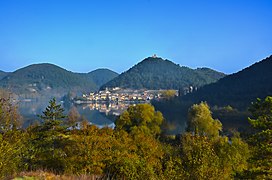 Lake and the citadel
 The lake with Labro's castle on the background
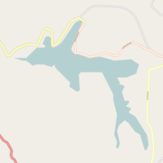 Lake map


External links
![]() Media related to Lake of Piediluco at Wikimedia Commons
Media related to Lake of Piediluco at Wikimedia Commons
| Authority control |
|
|---|
This Umbria location article is a stub. You can help Wikipedia by expanding it. |
This Lazio location article is a stub. You can help Wikipedia by expanding it. |
На других языках
- [en] Lago di Piediluco
[fr] Lac de Piediluco
Le lac de Piedulico (en italien : lago di Piediluco) est un lac lacustre du centre de l'Italie. Situé dans les provinces de Terni en Ombrie et de Province de Rieti aux confins du Latium.[it] Lago di Piediluco
Il lago di Piediluco si trova nell'Italia centrale: sulle sue rive sorge il paese di Piediluco, frazione di Terni. Collocato alle propaggini sud-orientali dell'Umbria, con un ramo che sconfina nel Lazio, il lago di Piediluco, pur con un'ampiezza di 1,85 km², può essere considerato il più grande bacino lacustre naturale della regione dopo il Trasimeno. Il nome sembra potersi interpretare come "ai piedi del bosco sacro"[1]. Insieme ai laghi Lungo, di Ripasottile e di Ventina situati in provincia di Rieti, rappresenta uno dei resti dell'antico Lacus Velinus, grande bacino di origine alluvionale venutosi a formare a partire dal Quaternario.Другой контент может иметь иную лицензию. Перед использованием материалов сайта WikiSort.org внимательно изучите правила лицензирования конкретных элементов наполнения сайта.
WikiSort.org - проект по пересортировке и дополнению контента Википедии