geo.wikisort.org - Reservoir
Lac La Loche is a lake in north west Saskatchewan near the Alberta border. The lake is part of the Churchill River system that flows into the Hudson Bay. The La Loche River at the southern end flows into Peter Pond Lake which is connected to Churchill Lake.
| Lac La Loche | |
|---|---|
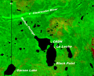
 Lac La Loche with a view towards the Portage | |
 Lac La Loche Location of Lac La Loche in Saskatchewan | |
| Location | Saskatchewan |
| Coordinates | 56°31′N 109°36′W |
| Primary inflows | Saleski River |
| Primary outflows | La Loche River |
| Basin countries | Canada |
| Surface area | 206 km2 (80 sq mi)[1][2] |
| Max. depth | 15.8 m (52 ft) |
| Surface elevation | 421 m (1,381 ft) |
| Islands | Dog Island |
| Settlements | La Loche, Saskatchewan, Clearwater River Dene Nation, Black Point, Saskatchewan |
Settlements on the lake include La Loche and Clearwater River (CRDN) on the eastern shore and Black Point on the southern shore. The estimated population of the three settlements in 2012 was 3500 people.[3]
The 19 kilometre Methye Portage or Portage La Loche at the northern end of the lake leads to the Clearwater River. The Portage a National Historic Site[4] is also part of the Clearwater River Provincial Park.
History


Fur trade posts were built on Lac La Loche soon after Peter Pond came through the Methye Portage in 1778.[5] An early indication of settlement comes from George Back who in 1822 noted in his journal: "We touched at the houses on the borders of the lake and embarked a man in each canoe".[6]
John Franklin's Coppermine expedition map of 1819-1820 shows Lac La Loche as Methye Lake and the La Loche River as the Methye River. Both names for the lake and the river were in use at this time. George Back who accompanied Franklin used Lac La Loche, La Loche River and Lac La Loche House (the Hudson Bay Post) in his journal. Alexander Mackenzie in "Voyages from Montreal" used both Portage la Loche and Mithy-Ouinigam Portage (in 1789-1793).[7]
Fish Species
The lake's fish species include: walleye, sauger, yellow perch, northern pike, lake trout, lake whitefish, cisco, white sucker, longnose sucker and burbot. [8]
See also
References
- fr:Lac La Loche (Saskatchewan)
- Google Maps
- "History of La Loche (La Loche 2011)". 2012-10-12.
- "Parks Canada (Methye Portage National Historic Event)". Retrieved 2012-10-12.
- "ENCYCLOPEDIA OF SASKATCHEWAN (list of forts in Northern Saskatchewan)". Retrieved 2012-10-12.
- Houston, Stuart (1994-10-25). Arctic Artist: The Journal and Paintings of George Back, Midshipman with Franklin, 1819-1822. McGill-Queens. p. 207.
- Mackenzie, Alexander Sir (1801), Voyages from Montreal, London: Printed for T. Cadell, Jun. and W. Davies ..., Cobbett and Morgan ..., and W. Creech, at Edinburgh, by R. Noble ..., ISBN 066533950X, 066533950X, retrieved 2014-04-10
- "Fish Species of Saskatchewan" (PDF). Archived from the original (PDF) on 2011-07-19. Retrieved 2012-10-13.
На других языках
- [en] Lac La Loche
[fr] Lac La Loche (Saskatchewan)
Le lac La Loche est un lac du nord-ouest de la Saskatchewan au Canada situé au sud du lac Athabasca près de la frontière de l'Alberta.Другой контент может иметь иную лицензию. Перед использованием материалов сайта WikiSort.org внимательно изучите правила лицензирования конкретных элементов наполнения сайта.
WikiSort.org - проект по пересортировке и дополнению контента Википедии