geo.wikisort.org - Reservoir
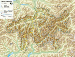
Lägh dal Lunghin (German: Lunghinsee) is a lake at an elevation of 2484 m, below the peak of Piz Lunghin, in the Graubünden, Switzerland. It is considered the source of the Inn River.
| Lägh dal Lunghin | |
|---|---|
 Lägh dal Lunghin | |
 Lägh dal Lunghin  Lägh dal Lunghin  Lägh dal Lunghin | |
| Location | Engadin, Grisons |
| Coordinates | 46°25′2″N 9°40′30″E |
| Native name | |
| Basin countries | Switzerland |
| Average depth | 9.2 m (30 ft) |
| Surface elevation | 2,484 m (8,150 ft) |
| Frozen | November - July (ice) |
 | |
See also
| Authority control |
|
|---|
This article related to a lake in Graubünden is a stub. You can help Wikipedia by expanding it. |
На других языках
[de] Lunghinsee
Der Lunghinsee oder Lägh dal Lunghin (in Bergeller Dialekt) ist ein kleiner See in den Albula-Alpen auf 2485 m ü. M. oberhalb Maloja im Kanton Graubünden. Er hat eine Fläche von ca. 5,2 ha.- [en] Lägh dal Lunghin
[fr] Lac de Lunghin
Le lac de Lunghin (Lunghinsee en allemand, ou Lägh dal Lunghin dans le dialecte du Val Bregaglia) est une petite étendue d'eau près de Maloja dans le canton des Grisons en Suisse.[it] Lago Lunghin
Il Lago Lunghin (Lunghinsee in tedesco) è un laghetto alpino situato alla quota di 2.484 m s.l.m., nel Cantone dei Grigioni, in Svizzera. È situato sulle pendici del Piz Lunghin (2.780 m) ed è considerato la sorgente del fiume Inn. A poca distanza, nei pressi del Passo Lunghin, è situato un triplo spartiacque molto significativo fra i bacini europei: a seconda del pendio sul quale le piogge cadono, finiscono con lo sfociare nel Mar Mediterraneo, nel Mare del Nord o nel Mar Nero.Текст в блоке "Читать" взят с сайта "Википедия" и доступен по лицензии Creative Commons Attribution-ShareAlike; в отдельных случаях могут действовать дополнительные условия.
Другой контент может иметь иную лицензию. Перед использованием материалов сайта WikiSort.org внимательно изучите правила лицензирования конкретных элементов наполнения сайта.
Другой контент может иметь иную лицензию. Перед использованием материалов сайта WikiSort.org внимательно изучите правила лицензирования конкретных элементов наполнения сайта.
2019-2025
WikiSort.org - проект по пересортировке и дополнению контента Википедии
WikiSort.org - проект по пересортировке и дополнению контента Википедии