geo.wikisort.org - Reservoir
Hebgen Lake is a reservoir created by the Hebgen Dam, located in Gallatin County in southwest Montana. It is well known for the 1959 Hebgen Lake earthquake (magnitude 7.1 to 7.5) which occurred nearby on August 17, 1959, forming Quake Lake, which is located immediately downstream.[4]
| Hebgen Lake | |
|---|---|
 Hebgen Lake | |
 Hebgen Lake Location in Montana | |
| Location | Gallatin County, Montana, United States |
| Coordinates | 44°46′56″N 111°14′01″W[1] |
| Type | Reservoir |
| Primary inflows | Madison River |
| Primary outflows | Madison River |
| Catchment area | 905 square miles (2,340 km2) |
| Basin countries | United States |
| Max. length | 15 miles (24 km) |
| Max. width | 4 miles (6.4 km) |
| Surface area | 12,563 acres (5,084 ha)[2] |
| Max. depth | 70 feet (21 m)[2] |
| Water volume | 386,200 acre⋅ft (476,400,000 m3)[2] |
| Shore length1 | 65 miles (105 km)[3] |
| Surface elevation | 6,539 ft (1,993 m)[1] |
| 1 Shore length is not a well-defined measure. | |
Recreation
Hebgen Lake and the surrounding area offer many recreational activities: camping, fishing, boating, and hiking. Campgrounds include Rainbow Point and Cherry Creek. Rainbow Point is the largest campground on the lake, offering four "loops." Each loop contains approximately 20 campsites. Each campsite can accommodate a full-size camper and one or two vehicles.[5]
See also
- Firehole Ranch
- Quake Lake
- Yellowstone Caldera
Images
 Hebgen Lake, Montana with a mountain as a backdrop
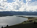 Madison Arm, looking towards Cherry Creek Campground
 Hebgen Lake, looking North from Rainbow Point Campground
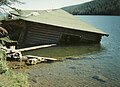 Cabin partially submerged by 1959 earthquake


References
- "Hebgen Lake". Geographic Names Information System. United States Geological Survey.
- "Hebgen Lake". Montana Fish, Wildlife & Parks. Retrieved July 13, 2020.
- "Hebgen Lake Is 65 Miles Around". Montana Standard. August 19, 1959. Archived from the original on March 8, 2012. Retrieved July 11, 2010.
- "Large Earthquakes in the United States". United States Geological Survey. Archived from the original on November 18, 2007.
- "Hebgen Lake Basin Area". Custer Gallatin National Forest. USDA Forest Service. Retrieved July 13, 2020.
External links
Wikimedia Commons has media related to Hebgen Lake.
- Hebgen Lake Bathymetric Map Montana Fish, Wildlife & Parks
Helena (capital) | ||
| Topics |
|  Seal of Montana |
| Society |
| |
| Regions |
| |
| Largest cities | ||
| Counties |
| |
Authority control | |
|---|---|
| General |
|
| National libraries | |
На других языках
- [en] Hebgen Lake
[fr] Lac Hebgen
Le lac Hebgen est un lac situé au sud-ouest de l'état américain du Montana. Il est connu du fait d'un tremblement de terre qui s'est déroulé le 17 août 1959. Ce tremblement de terre a fait apparaître une fissure dans le lac qui a entraîné une vidange partielle du lac. Les débris emportés avec la vidange se sont accumulés un peu plus bas en faisant apparaître le nouveau lac Quake.Текст в блоке "Читать" взят с сайта "Википедия" и доступен по лицензии Creative Commons Attribution-ShareAlike; в отдельных случаях могут действовать дополнительные условия.
Другой контент может иметь иную лицензию. Перед использованием материалов сайта WikiSort.org внимательно изучите правила лицензирования конкретных элементов наполнения сайта.
Другой контент может иметь иную лицензию. Перед использованием материалов сайта WikiSort.org внимательно изучите правила лицензирования конкретных элементов наполнения сайта.
2019-2026
WikiSort.org - проект по пересортировке и дополнению контента Википедии
WikiSort.org - проект по пересортировке и дополнению контента Википедии