geo.wikisort.org - Reservoir
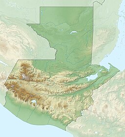
El Pino Lake is a lake in Guatemala. It is located 30 km south-southeast of Guatemala City, in the municipality of Barberena in the Santa Rosa Department. The lake has a surface area of 0.72 km² and a maximum depth of 18 m.[1][2] The lake waters are used for subsistence fishing, sport fishing, and swimming.
| El Pino Lake | |
|---|---|
 | |
| Location | Barberena, Santa Rosa |
| Coordinates | 14°20′40″N 90°23′38″W |
| Primary inflows | several small streams |
| Basin countries | Guatemala |
| Surface area | 0.72 km2 (0.28 sq mi) |
| Max. depth | 18 m (59 ft) |
| Surface elevation | 1,022 m (3,353 ft) |
Laguna El Pino National Park
| Laguna El Pino National Park | |
|---|---|
 Jacana spinosa | |
| Location | Santa Rosa (department), Guatemala |
| Area | 0.73 km2 (0.28 sq mi) |
| Elevation | 1,022 m (3,353 ft) |
| Established | Ac. Gubernativo 26-05-55 |
| Visitors | allowed |
| Operator | INAB |
In 1955 the lake, and a minor part of the lake shores, were designated a national park. The park, including the lake, covers an area of 0.73 km² and is managed by the National Forestry Institute (INAB) in conjunction with representatives of the local population. 20% of the lake shores are government property and 80% is privately owned.[1][3]
Vegetation consists mainly of floating beds of Water Hyacinth (Eichhornia crassipes), submergent beds of Waterweed (Elodea canadensis), and marshy areas with Spikerushes (Eleocharis elegans) and Giant Bulrush (Scirpus californicus). The lake shores have some wooded areas with Casuarina species, Cupressus lusitanica, Inga xalapensis and Pinus species. The surrounding area has coffee plantations.[2]
Species of waterfowl breeding in the lake area include Pied-billed Grebe (Podilymbus podiceps), Egret (Bubulcus ibis), Waterhen (Gallinula galeata), American Coot (Fulica americana) and Northern Jacana (Jacana spinosa).[2]
References
- "Wetland Inv - Guatemala" (xls). Ducks Unlimited. Retrieved 2009-06-11.
- "Wetland Inv - Guatemala" (PDF). wetlands.org. Archived from the original (pdf) on July 28, 2011. Retrieved 2009-06-11.
- CONAP. "Listado de Áreas Protegidas (enero, 2011)" (in Spanish). conap.gob.gt. Archived from the original (xls) on 2011-10-08. Retrieved 2011-06-14.
External links
 Media related to Laguna El Pino at Wikimedia Commons
На других языках
- [en] El Pino Lake
[es] Laguna El Pino
La Laguna El Pino está situada a unos 30 km al sudsudeste de la Ciudad de Guatemala, en el municipio de Santa Cruz Naranjo en el departamento de Santa Rosa, Guatemala. Tiene 0,72 km² y una profundidad máxima de 18 m .[1][2] El agua de la laguna es utilizada para la pesca de subsistencia, y para fines recreativos, como natación, pesca recreativa, deportes acuáticos y paseos en pequeñas embarcaciones.Другой контент может иметь иную лицензию. Перед использованием материалов сайта WikiSort.org внимательно изучите правила лицензирования конкретных элементов наполнения сайта.
WikiSort.org - проект по пересортировке и дополнению контента Википедии
