geo.wikisort.org - Reservoir
The Chott el Hodna (Arabic: شط الحضنة) is a very shallow saline lake in Algeria. It is located within an endorheic basin in the Hodna region, towards the eastern end of the Hautes Plaines.[2] The Chott el Hodna includes seasonal brackish and saline pools and marshes, but the central zone of the lake is characterized by a complete absence of vegetation.
| Chott el Hodna شط الحضنة | |
|---|---|
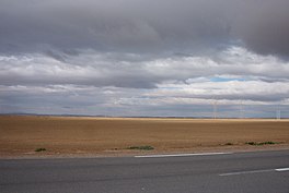
 Landscape of the Chott el Hodna | |
| Location | Hodna |
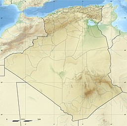
| Coordinates | 35.44°N 4.76°E |
| Type | Endorheic salt lake |
| Basin countries | Algeria |
| Max. length | 77 km (48 mi) |
| Max. width | 16 km (9.9 mi) |
| Surface area | 76,000 ha (190,000 acres) |
| Surface elevation | 394 m (1,293 ft) above sea level |
Ramsar Wetland | |
| Designated | 2 February 2001 |
| Reference no. | 1053[1] |
J. Despois argues that the Chott el Hodna is not a proper Chott, but a Sebkha.[3]
Ecology
The chott area provides an important habitat for certain endangered species such as the Cuvier's gazelle, the marbled duck and different kinds of bustards, as well as indigenous fish species. The Chott el Hodna was declared a Ramsar site on 2 February 2001.[4]
See also
- Geography of Algeria
- Hodna
References
- "Chott El Hodna". Ramsar Sites Information Service. Retrieved 25 April 2018.
- "Chott el-Hodna (lake, Algeria)". Encyclopædia Britannica. Retrieved 21 June 2013.
- J. Despois, Le Hodna (Algérie)
- The Annotated Ramsar List: Algeria
External links
- Mohamed Meouak, Le Hodna occidental entre régions méditerranéennes et plaines désertiques : organisation des terroirs, communautés rurales et productions agricoles au Moyen Âge
- Introduction: Les hautes plaines de l'Est de l'Algérie
На других языках
[de] Schott el Hodna
Der Schott el Hodna ist ein Salzsee (Schott) im Inneren von Algerien.- [en] Chott el Hodna
[fr] Chott el Hodna
Le chott el Hodna est un lac salé endoréique du nord-est de l'Algérie. Il est le deuxième plus grand lac d'Algérie (après le chott Melrhir) et donc l'un des plus grands d'Afrique du Nord.[ru] Эль-Ходна
Эль-Ходна[1] (араб. شط الحضنة) — мелкое солёное озеро на севере Алжира. Озеро расположено в пределах бессточного бассейна в горном массиве Ходна, что в восточной части Верхнего Плато гор Телль-Атлас[2]. Эль-Ходна включает в себя сезонные солоноватые озера и болота. Центральная часть озера характеризуется полным отсутствием растительности.Текст в блоке "Читать" взят с сайта "Википедия" и доступен по лицензии Creative Commons Attribution-ShareAlike; в отдельных случаях могут действовать дополнительные условия.
Другой контент может иметь иную лицензию. Перед использованием материалов сайта WikiSort.org внимательно изучите правила лицензирования конкретных элементов наполнения сайта.
Другой контент может иметь иную лицензию. Перед использованием материалов сайта WikiSort.org внимательно изучите правила лицензирования конкретных элементов наполнения сайта.
2019-2025
WikiSort.org - проект по пересортировке и дополнению контента Википедии
WikiSort.org - проект по пересортировке и дополнению контента Википедии
