geo.wikisort.org - Reservoir
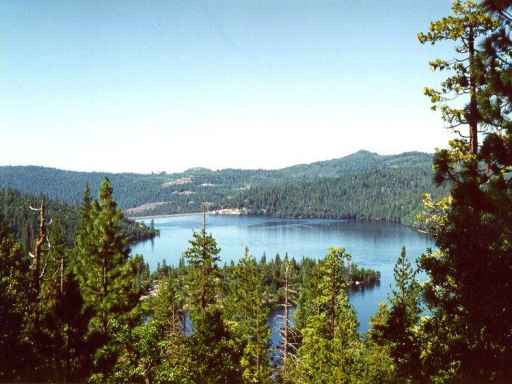
Cherry Lake (also known as Lake Lloyd) is an artificial lake in the Stanislaus National Forest of Tuolumne County, California, U.S.A., about 25 miles (40 km) east of the city of Sonora. It is at an elevation of 4,700 feet (1,433 m) on the western side of the Sierra Nevada, and lies just outside the western boundary of Yosemite National Park. The lake has a capacity of 273,500 acre⋅ft (337,400,000 m3) and is formed by Cherry Valley Dam on Cherry Creek.
This article includes a list of general references, but it lacks sufficient corresponding inline citations. (July 2011) |
| Cherry Lake | |
|---|---|
 | |
 Cherry Lake  Cherry Lake | |
| Location | Stanislaus National Forest Tuolumne County, California |
| Coordinates | 38.0013°N 119.9046°W |
| Type | Reservoir |
| Primary inflows | Cherry Creek |
| Primary outflows | Cherry Creek |
| Catchment area | 114 sq mi (300 km2) |
| Basin countries | United States |
| Surface area | 1,535 acres (621 ha) |
| Water volume | 273,500 acre⋅ft (337,400,000 m3) |
| Surface elevation | 1,420 m (4,660 ft) |
| References | U.S. Geological Survey Geographic Names Information System: Cherry Lake |
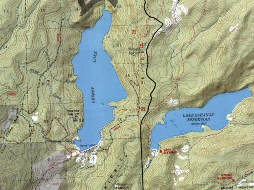
The East and West forks of Cherry Creek combine just a couple of miles before reaching the lake, while the North Fork joins the East Fork about 10 miles (16 km) earlier. All three forks begin in the Emigrant Wilderness and all of them flow roughly southwest. The North Fork's source is Emigrant Lake, which is at an elevation of 8,800 ft (2,680 m). The East Fork's source is a couple of miles (~6 – 8 km) southwest of the Mono County line and flows into Huckleberry Lake several miles (~6 – 8 km) later. The East and North forks meet several miles (~6 – 8 km) downstream of the lake. There are no lakes on the West Fork. Eleanor Creek, which forms Lake Eleanor, flows into Cherry Creek several miles (~6 – 8 km) downstream from Cherry Valley Dam. Lake Eleanor is another Hetch Hetchy Project facility. Cherry Creek flows into the Tuolumne River several miles (~6 – 8 km) later.
Cherry Valley Campground
This campground offers sites on both reservation and first come, first served basis. They have food storage containers, picnic tables and fire rings, with grates for cooking. Some sites offer beautiful lake vistas. The roads through the campground are paved. There are bathroom facilities but no showers. Running water is located every few campsites.
Cherry Valley Dam
The dam is composed of earth and rock-fill and has a height of 315 ft (96 m) above the original streambed. It was built by San Francisco City and County and the Modesto Irrigation District and Turlock Irrigation District.[1] It was completed in 1956. The lake stores water for the Hetch Hetchy Project, which supplies drinking water to the San Francisco Bay Area, Modesto and Turlock districts. Recreation available at the lake includes, boating, skiing, swimming and fishing. Human contact with the water is allowed because the water has to be filtered anyway. Water from the lake powers the Dion R. Holm Power Plant, a 165 MW hydroelectric facility.
See also
- Hetch Hetchy Reservoir
- List of dams and reservoirs in California
- List of lakes in California
- List of largest reservoirs of California
References
- Robert W. Righter, The Battle Over Hetch Hetchy: America's Most Controversial Dam and the Birth of Modern Environmentalism, Oxford University Press, 2005, p. 187.
- Department of Water Resources (2009). "Station Meta Data: Cherry Valley Dam (CHV)". California Data Exchange Center. State of California. Retrieved 2009-04-01.
- Paul McHugh (9 June 2005). "Yosemite, Stanislaus forest offer something for everyone". The San Francisco Chronicle. Retrieved 2009-04-01.
- "Cherry Lake". Columbia University Press. 2000. Archived from the original on 2007-05-19. Retrieved 2009-04-01.
External links
Другой контент может иметь иную лицензию. Перед использованием материалов сайта WikiSort.org внимательно изучите правила лицензирования конкретных элементов наполнения сайта.
WikiSort.org - проект по пересортировке и дополнению контента Википедии