geo.wikisort.org - Reservoir
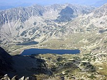
Lake Bucura is a glacier cirque lake, situated in the Retezat Mountains, in Romania. It is located south of the main ridge, at the base of Peleaga Peak, and at an altitude of about 2,040 m.
| Lake Bucura | |
|---|---|
 | |
 Lake Bucura | |
| Location | Retezat Mountains |
| Coordinates | 45°21.5′N 22°52.5′E |
| Type | Glacial |
| Basin countries | Romania |
| Max. length | 550 m (1,800 ft) |
| Max. width | 225 m (738 ft) |
| Surface area | 10.5 ha (26 acres)[1] |
| Max. depth | 15.5 m (51 ft) |
| Water volume | 625,000 m3 (507 acre⋅ft) |
| Shore length1 | 1,390 m (4,560 ft) |
| Surface elevation | 2,040 m (6,690 ft) |
| References | [1] |
| 1 Shore length is not a well-defined measure. | |

It is the largest glacier lake in Romania, having an area of over 105,000 square metres. It is 550 m in length, 160 m in width on average, and 225 m maximum width, for a perimeter of 1,390 m. The maximum depth is 15.5 m, and the volume 625,000 m³.

See also
- Lakes of Romania
Notes
External links
Wikimedia Commons has media related to Lacul Bucura.
На других языках
- [en] Bucura Lake
[ru] Букура
Букура (рум. Bucura) — ледниковое цирковое озеро, расположенное в горах нацпарка Ретезат в Румынии. Оно расположено к югу от главного хребта, на базе Пика Пелега, на высоте около 2040 м.Текст в блоке "Читать" взят с сайта "Википедия" и доступен по лицензии Creative Commons Attribution-ShareAlike; в отдельных случаях могут действовать дополнительные условия.
Другой контент может иметь иную лицензию. Перед использованием материалов сайта WikiSort.org внимательно изучите правила лицензирования конкретных элементов наполнения сайта.
Другой контент может иметь иную лицензию. Перед использованием материалов сайта WikiSort.org внимательно изучите правила лицензирования конкретных элементов наполнения сайта.
2019-2025
WikiSort.org - проект по пересортировке и дополнению контента Википедии
WikiSort.org - проект по пересортировке и дополнению контента Википедии