geo.wikisort.org - Reservoir
Bontecou Lake, also known as Tamarack Swamp,[2] is a shallow, man-made bifurcation lake in the towns of Stanford and Washington, in Dutchess County, New York, less than 5 mi (8 km) from the Village of Millbrook. Bontecou Lake straddles the drainage divide between the Wappinger Creek watershed to the west and the Tenmile River. Published estimates of its area vary between 113 acres (46 ha)[2] and 135 acres (55 ha),[3] but even the most conservative figures place it among the largest lakes in Dutchess County.[2] Parts of the lake are designated as a Critical Environmental Area, since the area is a crucial habitat for both migrating and breeding waterfowl.
| Bontecou Lake | |
|---|---|
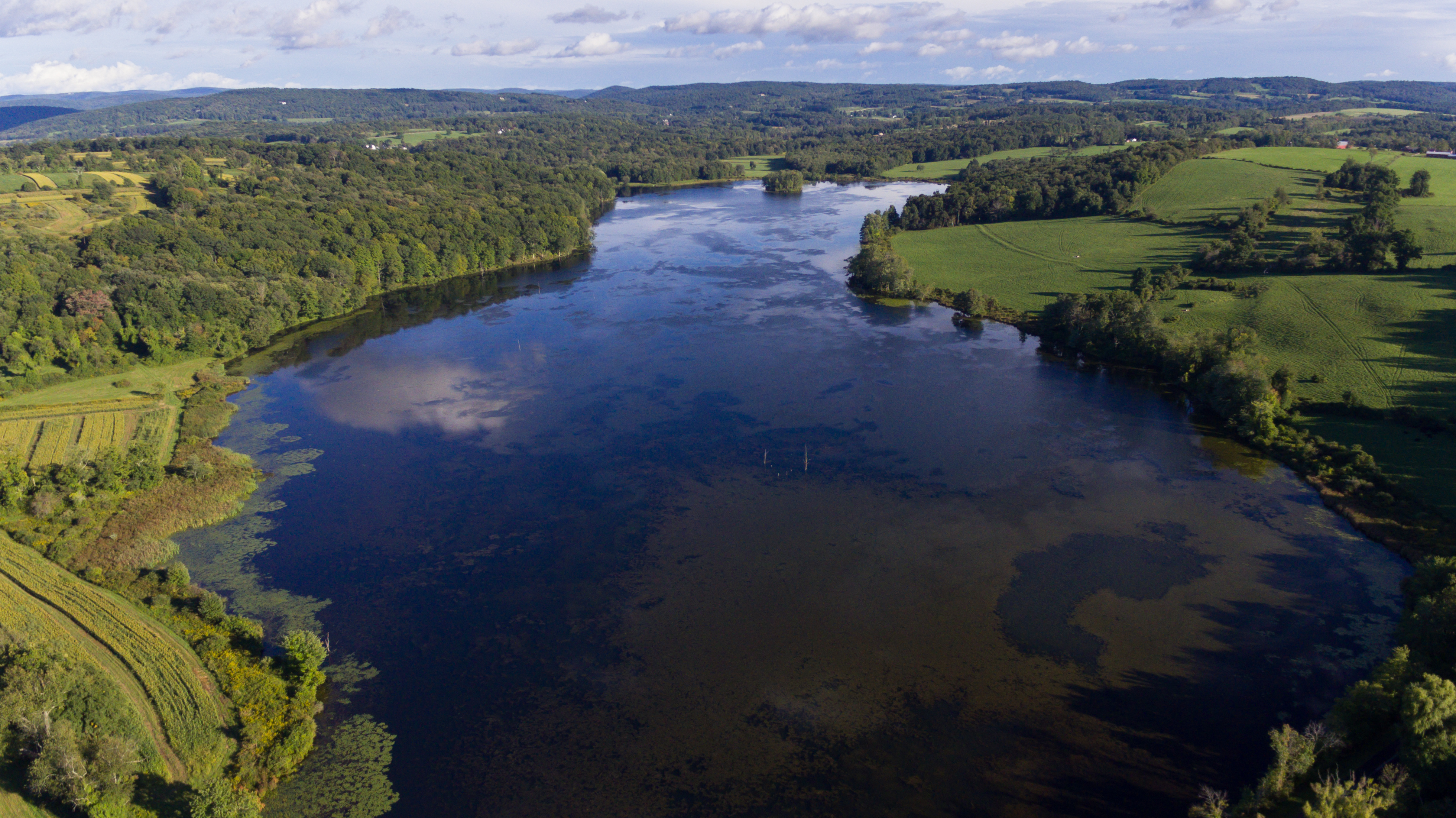
 Bontecou Lake in the autumn of 2016. Low water levels reveal many stumps of the tamarack trees that inhabited the wetland before it was flooded. | |
 Bontecou Lake | |
| Location | Stanford and Washington, New York, United States |
| Coordinates | 41°50′48″N 73°38′58″W |
| Type | Rural reservoir |
| Basin countries | United States |
| Designation | New York State Critical Environmental Area |
| First flooded | ca. 1956 |
| Surface area | At least 113 acres (46 ha) |
| Water volume | 350,000,000 US gallons (1.3×10⁹ l) |
| Surface elevation | 738 ft (225 m)[1] |
History and geography
Bontecou Lake is located on the property of Rally Farms, founded by Frederic H. Bontecou (who would later be elected a state senator) in 1926.[4] As the farm became renowned for its Angus cattle herd, water demands increased. Around 1956, responding to severe drought, Bontecou worked with the Dutchess County Soil and Water Conservation District to construct two earthen dams, impounding an existing, 5-to-6-acre (2 ha) pool of water at the center of a forested wetland known as Tamarack Swamp. The resulting reservoir held approximately 350,000,000 US gallons (1,300,000 m3) of water for agricultural purposes and flooded at least 113 acres (46 ha) of the swamp,[2][3] though estimates of its size range as high as 135 acres (55 ha).[3] Noted for quality of fishing by the Poughkeepsie Journal in 1968,[3] the lake experienced a severe fish die-off the next year. This was attributed to a harsh winter that killed aquatic plant life in the shallow reservoir, depleting water oxygen levels.[5]
The lake, oblong in shape and oriented from northwest–southeast, is surrounded by woods and farmlands.[6] It is bounded on the western end by Shuman Road.[3]
Hydrology
Bontecou Lake straddles the drainage divide between the Wappinger Creek watershed to the west and the Tenmile River watershed to the east, and it is unclear precisely where in the lake the two drainage basins diverge.[7] The western outflow is unofficially known as Tamarack Swamp Creek, and although its sub-watershed is the sixth largest out of sixteen within the Wappinger Creek catchment area, it only contributes around 2% among major tributaries to the Wappinger Creek's total flow.[7] During a 1999 survey, freshwater flooding from Hurricane Floyd brought Tamarack Swamp Creek discharge to 42.7 cu ft/s (1.21 m3/s) on September 17, compared to 0.3 cu ft/s (0.0085 m3/s) amid a dry spell in the previous month.[7] Among the 13 bodies of water larger than 20 acres (8 ha) partially or wholly within the Wappinger Creek watershed, Bontecou Lake is the only one that has not been assigned a New York State Department of Environmental Conservation (NYSDEC) water quality classification.[7]
Wildlife and conservation
Bontecou Lake is an important wildlife habitat, and in 1987, the town of Stanford designated its portion of the lake, along with parts of the adjacent wetlands, as a Critical Environmental Area to protect the large numbers of migratory and breeding waterfowl that seek refuge there.[8][9] The NYSDEC also monitors and regulates land usage in a 320-acre (130 ha) tract surrounding and including the lake, as directed by the New York State Freshwater Wetlands Act of 1975.[10]
One of the first breeding pairs of Canada geese in Dutchess County was recorded here in 1964; before that year, only one other nesting site had been observed in the county's history.[11] Today, the lake and swamp are home to hundreds of Canada geese year-round, with many thousands using the area as a stop-over point during migration periods.[6] The first cackling goose ever documented in the county was also spotted at Bontecou Lake in May 1977.[11] Dead trees extending above the surface of the water quickly made this a preferred breeding ground for great blue herons,[3] which continue to nest on the eastern side of the lake. Though only a handful of the trees remain standing, they provide nesting opportunities for several bird species,[6] including the eastern bluebird, for which the partially submerged trees constitute a relatively rare natural breeding site away from buildings and free of competitors.[1]
Though located entirely on private property, the lake is a popular destination for birders who have been granted permission to access the land, either individually or through birding club membership.[6]

References
- Kiviat, Erik (Winter 1982). "Eastern bluebird remote natural nest sites" (PDF). Kingbird. The Federation of New York State Bird Clubs. 32 (1): 6. Retrieved September 4, 2018.
- Dutchess County Department of Planning; Dutchess County Environmental Management Council (October 1985). 1985 Dutchess County Natural Resources Inventory (Report). Dutchess County Cooperative Extension Association. pp. 147, 185. Retrieved September 4, 2018.
- "365 ponds reflect contribution to county of soil, water district". The Poughkeepsie Journal. February 18, 1968. p. 7-D. Retrieved September 4, 2018 – via Newspapers.com.

- "Angus Along the Hudson: Tour Stops". National Angus Conference. Retrieved September 4, 2018.
- "Fish kill hurts ponds". The Poughkeepsie Journal. April 6, 1969. p. 2-B. Retrieved September 4, 2018 – via Newspapers.com.
- Popko, Adrienne; DeOrsey, Stan (January 1, 2016). Where to bird in Dutchess County (PDF) (Third ed.). Ralph T. Waterman Bird Club, Inc. p. 48. Retrieved September 4, 2018.
- Dutchess County Environmental Management Council. Natural Resource Management Plan for the Wappinger Creek Watershed (PDF) (Report). Village of Wappingers Falls. pp. 1, 60. Archived from the original (PDF) on January 25, 2017. Retrieved September 4, 2018.
- "Critical Environmental Areas in Dutchess County". New York State Department of Environmental Conservation. Retrieved September 4, 2018.
- "Bontecou Lake Critical Environmental Area (CEA)" (PDF). New York State Department of Environmental Conservation. Retrieved September 4, 2018.
- 2014 Comprehensive Plan Update (PDF) (Report). Town of Washington. p. 89. Retrieved September 4, 2018.[permanent dead link]
- Butler, Barbara A; DeOrsey, Stan (2017). The Birds of Dutchess County New York (PDF). Ralph T. Waterman Bird Club, Inc. p. 59. ISBN 9780963519023. Retrieved September 4, 2018.
Другой контент может иметь иную лицензию. Перед использованием материалов сайта WikiSort.org внимательно изучите правила лицензирования конкретных элементов наполнения сайта.
WikiSort.org - проект по пересортировке и дополнению контента Википедии