geo.wikisort.org - Reservoir
Bear Lake is a natural freshwater lake on the Idaho–Utah border in the Western United States. About 109 square miles (280 km2) in size, it is split about equally between the two states; its Utah portion comprises the second-largest natural freshwater lake in Utah, after Utah Lake.[1] The lake has been called the "Caribbean of the Rockies" for its unique turquoise-blue color, which is due to the refraction of calcium carbonate (limestone) deposits suspended in the lake.[2] It's water properties have led to the evolution of several unique species of fauna that occur only within the lake.[3] Bear Lake is over 250,000 years old.[4] It was formed by fault subsidence that continues today, slowly deepening the lake along the eastern side.[5] In 1911 the majority of the flow of the Bear River was diverted into Bear Lake via Mud Lake and a canal from Stewart Dam, ending 11,000 years of separation between the lake and that river system.[6]
| Bear Lake | |
|---|---|
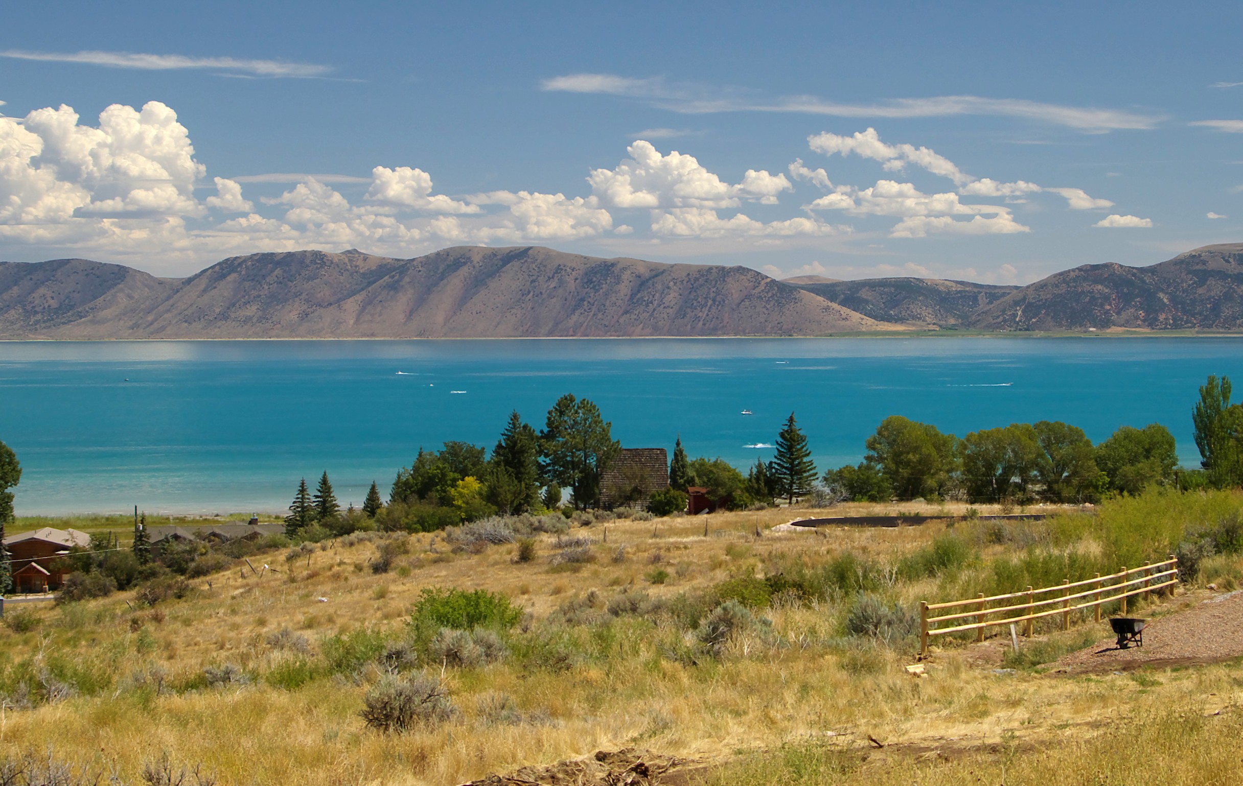 The lake's intense turquoise color is due to the presence of suspended limestone | |
 Bear Lake | |
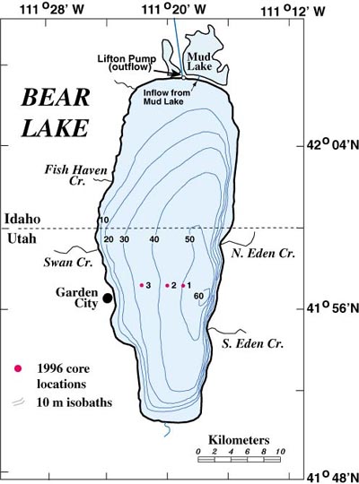 Bathymetric chart | |
| Location | Bear Lake County, Idaho Rich County, Utah, U.S. |
| Coordinates | 42°00′N 111°20′W |
| Primary inflows | Bear River diversion Creeks: Fish Haven, North Eden, South Eden, Swan Creek, St. Charles |
| Primary outflows | Bear Lake Outlet Canal |
| Catchment area | 5,862,957 acres (23,727 km2) |
| Basin countries | United States |
| Max. length | 18.3 mi (29.5 km) |
| Max. width | 7.1 mi (11.4 km) |
| Surface area | 109 sq mi (280 km2) |
| Average depth | 94 ft (29 m) |
| Max. depth | 208 ft (63 m) |
| Water volume | 6,500,000 acre⋅ft (8.02 km3) |
| Residence time | 19.6 years |
| Shore length1 | 48 mi (77 km) |
| Surface elevation | 5,924 ft (1,806 m) |
| Settlements | Garden City, Utah, Laketown, Utah, Fish Haven, Idaho |
| 1 Shore length is not a well-defined measure. | |
Today the lake is a popular destination for tourists and sports enthusiasts, and the surrounding valley has gained a reputation for having high-quality raspberries.[7]
History
The first known inhabitants of the Bear Lake Valley were Shoshone tribes, but the area was known to many Native Americans. The first record of Europeans seeing the lake is from 1818 when French-Canadian trappers working for the North West Company followed the Bear River upstream to the valley.
Originally named "Black Bear Lake" by Donald McKenzie, an explorer for the North West Fur Company who explored the lake in 1819, the name was later shortened to Bear Lake.[8] Following his exploration of the lake, Mckenzie held what is known to be the largest rendezvous of Native Americans to take place in the Rocky Mountains. Nearly 10,000 American Indians from various tribes camped along 7 miles of Bear Lake's north shore, trading with Mckenzie and his trapping company.[9]
The south end of the lake, in the area of modern-day Laketown, was also the location of two of the annual Rocky Mountain Rendezvous in the summers of 1827 and 1828. Mountain men, including Jedediah Smith and Jim Bridger, gathered at this location, along with trade goods suppliers and American Indians from several different tribes. The mountain men and Indians sold their furs in exchange for various store goods and supplies, and several weeks were spent reveling in assorted amusements and liquor.[10][11]
Smith's arrival in June 1827 was especially historic, as it marked the completion of the first ever overland round-trip to California from the United States. He wrote in his journal: "My arrival caused a considerable bustle in camp for myself and party had been given up as lost."[12]
Although the lake lies relatively near the Oregon Trail, which runs north and east of the lake, and was traveled by many pioneers between 1836 and the 1850s, it seems none of them went south enough to view the lake. It was not until 1863 that Mormon pioneers led by Charles C. Rich settled in the Bear Lake Valley, but they made an agreement with Native Americans, which left most of the Utah portion of the valley in Indian possession. The Mormons gradually moved south and established the villages of Garden City, Pickelville, and Laketown, each along the lake's shore.
In 1911 a diversion was constructed at Wardboro, Idaho that redirected the majority of the flow of the Bear River into Bear Lake via Mud Lake. Water then exits Bear Lake via an outlet canal to rejoin the Bear River. This allows the upper 6.5 meters of Bear Lake to act as a reservoir for the Bear River, storing spring runoff for irrigation later in the year. Before the construction of this connection, Bear Lake had been isolated from the Bear River for 11,000 years, though Bear River has connected to Bear Lake naturally several times over the 250,000-year existence of the Lake.[6]
In later years, Bear Lake became a resort and recreation area, with many developers selling lake shore and mountain view lots. The beaches of Lakota and Ideal were given to private development in the 1970s, including the Blue Water and Sweetwater developments. The State of Utah bought the far southeast beach for use as a state park, and the state also operates a marina on the lake's west side.
Geographic features

Formed in a half graben valley straddling the Idaho-Utah border, the lake has an approximate area of 109 square miles (280 km2) and sits at an elevation of 5,924 feet (1,806 m) along the northeast side of the Wasatch Range and the east side of the Bear River Mountains.[13]
The lake and surrounding areas are popular summer tourist destinations. The lake has many marinas, beaches, and two tourist towns in Utah: Garden City and Laketown. It also has two state parks, each named Bear Lake State Park: one in Idaho and one in Utah. The Utah state park includes a one-half-mile-long Rendezvous Beach at the south end of the lake, the location of the 1827 and 1828 rendezvous, and a three-mile-long Cisco Beach on the east side, plus the additional campground, marina, and boat ramp areas. The Idaho state park includes north and an east unit, each with a one-mile-long beach. Bear Lake National Wildlife Refuge extends up from the north end of the lake.
Native and naturalized animals

Bear Lake has a high rate of endemism (native species not naturally found anywhere else). Several species evolved in the lake's waters, but many went extinct after the diversion of the Bear River into the lake.[3] Surviving known endemic species of fish include the Bear Lake strain of the Bonneville cutthroat trout,[14] Bonneville cisco, Bonneville whitefish, Bear Lake whitefish, and Bear Lake sculpin.[3][15] There have been attempts to transplant these species to other areas without success,[16] with the exception of the Bear Lake Cutthroat Trout strain. This trout has flourished in other large bodies of cool water, including the Strawberry and Scofield reservoirs.
"The Bonneville cisco eat only small aquatic invertebrates or zooplankton. They are eaten by larger fish in the lake including whitefish, Bonneville Cutthroat Trout, and introduced lake trout."[16] Although several fish species have been introduced into the lake, those native species which survived the Bear River diversion have continued to thrive under careful management.[citation needed]
Water from the lake is used for irrigation in the nearby Bear Valley in southeast Idaho and for recreational fishing. The lake drains via the Bear River Outlet, completed in 1915, into the Bear River which eventually flows into the northeast portion of Great Salt Lake.
Raspberry cultivation
Bear Lake has become famous for the surrounding valley's crops of raspberries and for the annual Raspberry Days festival held in Garden City to celebrate the harvest of raspberries, generally during the first week of August. This event is said to bring thousands of people from all over the world and features rodeos, parades, fireworks, dances, a craft fair, "Miss Berry Princess contest", raspberry recipe cookoff, a talent show, fun run and concerts.[7][17]
A majority of the originally introduced Bear Lake Raspberry plants were infected with a fungal virus during 2001 called the "raspberry bushy dwarf virus".[18] Fewer than five acres survived. The epidemic resulted in most of the large berry businesses in Garden City being wiped out. Some crop acreage was replaced by newly introduced virus-resistant plants. Although some varieties of raspberries are resistant to the virus, none produce fruit as succulent and sweet as the previously cultivated plants.[citation needed] The raspberry business has since been redeveloped, and raspberries are again thriving, mostly in the southern end of the valley.[citation needed]
Recreation
One of the main reasons Bear Lake has become a popular vacation destination is due to the high amount of recreational activities and attractions that are available throughout the year. In the summertime, swimming, water-skiing, jet-skiing, boating, and sailing draw people to the water. Tourists also pass the time exploring the local caves or golf courses or taking mountain trails on foot, bike, ATV, or horseback. In the cooler months, hunting, snow skiing, snowmobiling, or ice fishing are common attractions.[19] Many people try a "famous raspberry shake"[20] at one of the local restaurants, or see a play at the Pickleville Playhouse.
See also
- Bear Lake National Wildlife Refuge
- Bear Lake monster, a legend
 Lakes portal
References
- Bear Lake history & facts. Utah Division of Wildlife Resources.
- Bear Lake State Park. Visitutah.com
- Bear Lake Geological Background: Endemism Archived May 22, 2006, at the Wayback Machine. U.S. Geological Survey.
- "See Rosenbaum and Kaufman, 2009". Archived from the original on 2012-05-31. Retrieved 2009-04-17.
- Bear Lake Geological Background: Tectonism Archived May 22, 2006, at the Wayback Machine U.S. Geological Survey.
- Bear River watershed information system
- Bear Lake Raspberry Days. Utah Outdoor Activities.
- Bear Lake State Park: In Depth Archived September 24, 2006, at the Wayback Machine. Utah State Parks and Recreation.
- "Davis County Clipper | 1991-04-09 | Black Bear Lake Discovered in 1818". newspapers.lib.utah.edu. Retrieved 2021-03-26.
- "Mountain Men and Life in the Rocky: Rendezvous".
- Eddins, Ned O. "Mountain Man Rendezvous Sites". Archived from the original on 2012-11-15.
- Smith, Jedediah S., [Harrison G. Rogers], and George R. Brooks (ed.). The Southwest Expedition of Jedediah S. Smith: His Personal Account of the Journey to California, 1826–1827, p. 197. Lincoln and London, University of Nebraska Press, [1977] 1989. ISBN 978-0-8032-9197-3
- Bear Lake (PDF). Division of Water Quality (Report). Watersheds/Lakes. State of Utah. Archived from the original (PDF) on 2006-07-24.
- Neilson, M.E. (2012-06-06). "Oncorhynchus clarkii utah (Suckley, 1874) (Bonneville Cutthroat Trout)". Nonindigenous Aquatic Species database / Wetland and Aquatic Research Center. Gainesville, FL: USGS.
- Smart, Earl W. (March 6, 1954). "Here's 'inside info' on fish population at famous Bear Lake". Deseret News. (Salt Lake City, Utah). p. A5.
- Bingham, Lyle; Goede, Ron (2009-02-10). "Bonneville Cisco". Bridgerland Audubon Society. Wild about Utah. Archived from the original on 2012-10-31. Retrieved 2020-12-20.
- Bear Lake Raspberry Days. The Logan Library. Deseret Digital Media.
{{cite AV media}}: CS1 maint: url-status (link) - writer, Kevin Opsahl staff. "Raspberry roulette: Production up statewide, while Bear Lake struggles". The Herald Journal. Retrieved 2021-03-29.
- "Bear Lake recreation map". Visit Bear Lake. Retrieved 2021-03-29.
Find fun things to do in Bear Lake, Utah, and Idaho.
- "Bear Lake". Visit Bear Lake. Restaurants, delis, grocery & convenience stores in Utah & Idaho. Retrieved 2021-03-29.
- Peterson, F. Ross (1994). "Bear Lake". In Powell, Allan Kent (ed.). Utah History Encyclopedia. Salt Lake City, Utah: University of Utah Press. ISBN 0874804256. OCLC 30473917.
External links
Authority control | |
|---|---|
| General |
|
| National libraries | |
На других языках
[de] Bear Lake (Idaho/Utah)
Bear Lake (deutsch Bärensee) ist ein natürlicher See auf der Grenze der US-Bundesstaaten Idaho und Utah.- [en] Bear Lake (Idaho–Utah)
[es] Lago del Oso
El lago Bear (en inglés, Bear Lake, literalmente, «lago del Oso»)[1][2] es un lago natural de agua dulce ubicado en la frontera entre los estados de Utah e Idaho en el Oeste estadounidense. Con 282 km², es el segundo lago natural más grande de agua dulce de Utah pero como su nombre lo dice hay vive un oso[3]Rocosas» (Caribbean of the Rockies), por su singular color azul turquesa, resultado de los depósitos de caliza en suspensión en el agua.[4] Esas propiedades del agua han llevado a la evolución de varias especies únicas que viven, naturalmente sólo aquí, en el lago.[5] El lago Bear tiene más de 250.000 años.[6] Se ha formado por una falla de subsidencia, que continúa hoy en día, profundizando lentamente el lago a lo largo de la parte oriental.[7][fr] Lac Bear (Idaho et Utah)
Le lac Bear (en anglais : Bear Lake) est un lac américain dans le comté de Bear Lake, en Idaho, et le comté de Rich, en Utah. Il est situé à 1 806 mètres d'altitude.[ru] Бэр (озеро)
Бэр[1] (англ. Bear Lake) — пресноводное озеро на границе штатов Юта и Айдахо, США. Площадь зеркала составляет около 282 км² при средней глубине в 29 м и максимальной глубине 63 м. Насчитывает около 29,5 км в длину и 11,4 км в ширину. Расположено на высоте 1821 м над уровнем моря[2], вдоль северо-восточной стороны горного хребта Уосатч и восточной стороны хребта Бэр-Ривер[3]. Площадь поверхности — 280 км².[источник не указан 414 дней]Другой контент может иметь иную лицензию. Перед использованием материалов сайта WikiSort.org внимательно изучите правила лицензирования конкретных элементов наполнения сайта.
WikiSort.org - проект по пересортировке и дополнению контента Википедии