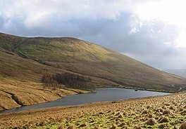
geo.wikisort.org - Reservoir
National grid reference NS27609150
| Auchengaich Reservoir | |
|---|---|
 | |
| Location | Glen Fruin, Scotland |
| Coordinates | 56.0860°N 4.7705°W |
| Type | Reservoir |
| Primary outflows | Auchengaich Burn |
| Basin countries | Scotland, United Kingdom |
| Surface area | 34,000 m2 (370,000 sq ft) |
| Surface elevation | 244 m (801 ft) |
Auchengaich Reservoir was created in 1942 through the construction of an earthfill dam built by the military to supply water to Helensburgh and the Gareloch during World War II.[1]
See also
- List of reservoirs and dams in the United Kingdom
Sources
Текст в блоке "Читать" взят с сайта "Википедия" и доступен по лицензии Creative Commons Attribution-ShareAlike; в отдельных случаях могут действовать дополнительные условия.
Другой контент может иметь иную лицензию. Перед использованием материалов сайта WikiSort.org внимательно изучите правила лицензирования конкретных элементов наполнения сайта.
Другой контент может иметь иную лицензию. Перед использованием материалов сайта WikiSort.org внимательно изучите правила лицензирования конкретных элементов наполнения сайта.
2019-2025
WikiSort.org - проект по пересортировке и дополнению контента Википедии
WikiSort.org - проект по пересортировке и дополнению контента Википедии
