geo.wikisort.org - Stillgewässer
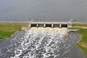
Die Talsperre Lake Darling (englisch Lake Darling Dam) befindet sich im Ward County im US-Bundesstaat North Dakota. Sie staut den Souris River zu einem Stausee auf. Die Stadt Minot befindet sich ca. 30 km südöstlich der Talsperre; die Minot Air Force Base liegt ca. 10 km östlich.
| Talsperre Lake Darling | |||||||
|---|---|---|---|---|---|---|---|
 | |||||||
| |||||||
| Koordinaten | 48° 27′ 28″ N, 101° 35′ 2″ W | ||||||
| Daten zum Bauwerk | |||||||
| Bauzeit: | 1935 bis 1936 | ||||||
| Daten zum Stausee | |||||||
| Höhenlage (bei Stauziel) | 486 m | ||||||
| Wasseroberfläche | 38,8 km² | ||||||
Der Staudamm wurde von 1935 bis 1936 errichtet.[1]
Absperrbauwerk
Das Absperrbauwerk ist ein Erdschüttdamm. Die Wehranlage besteht aus fünf Toren.
Stausee
Das normale Stauziel beträgt 486 m (1594,7 ft); maximal sind 488 m (1601 ft) zulässig.[2] Beim normalen Stauziel erstreckt sich der Stausee über eine Fläche von rund 38,8 km² (9600 acres). Der Stausee ist Bestandteil des Naturschutzgebietes Upper Souris National Wildlife Refuge, das sich über 56 km (35 miles) entlang des Flusses erstreckt.[1]
Im Juni 2011 kam es entlang des Souris River zu schweren Überschwemmungen. Der Abfluss des Souris River an der Talsperre Lake Darling lag am 25. Juni 2011 bei 735 m³/s (26.000 cft/s).[2]
Einzelnachweise
- Upper Souris National Wildlife Refuge, ND. www.recreation.gov, abgerufen am 6. September 2018 (englisch).
- 2011 POST- FLOOD REPORT For the SOURIS RIVER BASIN. (PDF) United States Army Corps of Engineers, S. 47–48 (39–40), abgerufen am 6. September 2018 (englisch).
На других языках
- [de] Talsperre Lake Darling
[en] Lake Darling Dam
Lake Darling Dam is an earthen embankment dam on the Souris River located 20 mi (32 km) northwest of Minot, in Ward County, North Dakota. The dam began impounding water in April 1936 and was completed July of that year. It was created for the purposes of water storage and conservation.[2] It is part of the Upper Souris National Wildlife Refuge and is owned by the United States Fish and Wildlife Service. The dam and lake are named after Jay N. "Ding" Darling, the first director of the Bureau of Biological Survey.[3] Although the dam is located in Ward County, Lake Darling is almost entirely located in Renville County, to its north.Другой контент может иметь иную лицензию. Перед использованием материалов сайта WikiSort.org внимательно изучите правила лицензирования конкретных элементов наполнения сайта.
WikiSort.org - проект по пересортировке и дополнению контента Википедии
