geo.wikisort.org - Горы
Худу́ — действующий стратовулкан в штате Британская Колумбия (Канада). Более точно массив подлёдных вулканов, являющихся: гора Худу, Медвежонок вулканический купол, ледник Худу, группа шлаковых конусов и маар на вершине. Известно только два извержения: 7000 год до н. э., 2002 год.
| Худу | |
|---|---|
| англ. Hoodoo Mountain | |
 Западный склон (20 мая 2004 г.). | |
| Характеристики | |
| Форма вулкана | Стратовулкан |
| Период образования | Плейстоцен |
| Последнее извержение | 7050 г. до н.э. |
| Высшая точка | |
| Абсолютная высота | 1850[1] м |
| Относительная высота | 900 м |
| Расположение | |
| 56°46′20″ с. ш. 131°17′40″ з. д.HGЯO | |
| Страна |
|
| Горная система | Кордильеры |
| Хребет или массив | Береговой хребет |

Галерея
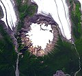 Вид на Худу из космоса
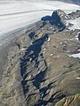 Северный склон
 Южный склон


Примечания
- Hoodoo Mountain (англ.). Global Volcanism Program. Smithsonian Institution.
Ссылки
- Hoodoo Mountain (англ.). Global Volcanism Program. Smithsonian Institution.
- John Seach. Hoodoo Mountain Volcano (англ.). Volcano Live. Дата обращения: 11 февраля 2022.
На других языках
[en] Hoodoo Mountain
Hoodoo Mountain, sometimes referred to as Hoodoo Volcano, is a potentially active stratovolcano in the Northern Interior of British Columbia, Canada. It is located 25 kilometres (16 miles) northeast of the Alaska–British Columbia border on the north side of the Iskut River opposite of the mouth of the Craig River. With a summit elevation of 1,850 metres (6,070 feet) and a topographic prominence of 900 metres (3,000 feet), Hoodoo Mountain is one of many prominent peaks within the Boundary Ranges of the Coast Mountains. Its flat-topped summit is covered by an ice cap more than 100 metres (330 feet) thick and at least 3 kilometres (1.9 miles) in diameter. Two valley glaciers surrounding the northwestern and northeastern sides of the mountain have retreated significantly over the last hundred years. They both originate from a large icefield to the north and are the sources of two meltwater streams. These streams flow along the western and eastern sides of the volcano before draining into the Iskut River.[fr] Hoodoo Mountain
Hoodoo Mountain, parfois appelée volcan Hoodoo, est un stratovolcan potentiellement actif situé dans l'intérieur nord de la Colombie-Britannique, au Canada. Il est situé à 25 km au nord-est de la frontière entre l'Alaska et la Colombie-Britannique, sur le côté nord de la rivière Iskut, en face de l'embouchure de la rivière Craig. Avec une altitude de 1 850 m et une proéminence topographique de 900 m, Hoodoo Mountain est l'un des nombreux sommets proéminents des Boundary Ranges de la Chaîne Côtière. Son sommet au sommet plat est recouvert d'une calotte glaciaire de plus de 100 m d'épaisseur et d'au moins 3 km de diamètre. Deux glaciers de vallée entourant les flancs nord-ouest et nord-est de la montagne ont reculé de manière significative au cours des cent dernières années. Ils proviennent tous deux d'un grand champ de glace situé au nord et sont à l'origine de deux ruisseaux d'eau de fonte. Ces ruisseaux s'écoulent le long des côtés ouest et est du volcan avant de se déverser dans la rivière Iskut.- [ru] Худу
Текст в блоке "Читать" взят с сайта "Википедия" и доступен по лицензии Creative Commons Attribution-ShareAlike; в отдельных случаях могут действовать дополнительные условия.
Другой контент может иметь иную лицензию. Перед использованием материалов сайта WikiSort.org внимательно изучите правила лицензирования конкретных элементов наполнения сайта.
Другой контент может иметь иную лицензию. Перед использованием материалов сайта WikiSort.org внимательно изучите правила лицензирования конкретных элементов наполнения сайта.
2019-2025
WikiSort.org - проект по пересортировке и дополнению контента Википедии
WikiSort.org - проект по пересортировке и дополнению контента Википедии