geo.wikisort.org - Горы
Мальёвица (болг. Мальовица) — вершина в Рильских горах, одна из высочайших точек Болгарии (2729 м над уровнем моря).
| Мальёвица | |
|---|---|
| болг. Мальовица | |
 Мальёвица зимой. | |
| Высшая точка | |
| Абсолютная высота | 2729[1] м |
| Расположение | |
| 42°10′25″ с. ш. 23°21′47″ в. д.HGЯO | |
| Страна |
|
| Область | Кюстендилская область |
| Горная система | Рила |
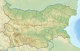

Мальёвица находится в северо-западной части горного массива, к северу от Рильского монастыря.
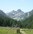
Район горы пользуется большой популярности у туристов: зимой на склонах действует горнолыжный курорт, северные и восточные склоны имеют почти отвестные скальные участки, что пользуется популярностью среди скалолазов и альпинистов. На склонах Мальёвицы находятся ледниковые озёра — Мальёвицкие, Эленские и др.
Галерея
 Вид на вершину летом
 Склоны Мальёвицы
 Домики на склонах горы


Примечания
- Peakbagger.com. Дата обращения: 15 декабря 2012. Архивировано 25 июня 2012 года.
Ссылки
На других языках
[de] Maljowiza
Maljowiza (bulgarisch Мальовица) ist ein Berg im nordwestlichen Teil des Rilagebirges, Oblast Kjustendil in Bulgarien. Als Maljowiza-Gebiet wird der nordwestliche Teil des Rilagebirges bezeichnet, in dem der Maljowiza-Gipfel liegt. Unterhalb dieses Gipfels erstreckt sich das Maljowiza-Tal mit dem Maljowiza-Fluss und der gleichnamigen Berghütte. Am Ende des Tals befindet sich der Maljowiza-Komplex, der aus einer Bergretterschule, einem Hotel und einem kleinen Skigebiet besteht.[en] Malyovitsa
Malyovitsa (Bulgarian: Мальовица [mɐˈʎɔvit͡sɐ]) is a peak in the northwestern part of the Rila Mountain in southwestern Bulgaria. It is 2,729 m high and is one of the most popular tourist regions in the mountain. Its northern and eastern slopes are steep and almost inaccessible while the southern and south-western slopes are more oblique.[1] The Rila Monastery is situated at its southern foothills facing the valley of the Rilska River, and Malyovitsa Ski Centre — with two downhill tracks and two ski drags — is to the north. The main starting point for treks in the region is Malyovitsa Hut at an altitude of 1,700 m at about 2 hours walk from the top of the summit.[1] The three Malyovishki Lakes are situated to the north of the summit, while to the southeast the Elenski Lakes, also three, are located in a deep cirque.[1][2]- [ru] Мальёвица
Текст в блоке "Читать" взят с сайта "Википедия" и доступен по лицензии Creative Commons Attribution-ShareAlike; в отдельных случаях могут действовать дополнительные условия.
Другой контент может иметь иную лицензию. Перед использованием материалов сайта WikiSort.org внимательно изучите правила лицензирования конкретных элементов наполнения сайта.
Другой контент может иметь иную лицензию. Перед использованием материалов сайта WikiSort.org внимательно изучите правила лицензирования конкретных элементов наполнения сайта.
2019-2025
WikiSort.org - проект по пересортировке и дополнению контента Википедии
WikiSort.org - проект по пересортировке и дополнению контента Википедии