geo.wikisort.org - Montagne
I Sudeti (in tedesco: Sudeten; in ceco: Krkonošsko-jesenická subprovincie o Sudety; in polacco: Sudety) sono un sistema montuoso al confine tra la Germania (Sassonia), la Polonia (Slesia) e la Repubblica Ceca (Boemia, Moravia e Slesia). Poiché il nome, nel periodo compreso fra le due guerre mondiali, designò con un buon grado di approssimazione l'intera area tedescofona all'interno di Boemia e Moravia, con questa denominazione si definiscono talvolta le popolazioni tedesche ivi insediate fino alla seconda guerra mondiale (Sudetendeutsche o Tedeschi dei Sudeti).
| Sudeti | |
|---|---|
 | |
| Continente | Europa |
| Stati | |
| Cima più elevata | Sněžka (1.602 m s.l.m.) |
| Massicci principali | Monti dei Giganti |
La catena dei Sudeti comprende in particolare i Monti dei Giganti (in tedesco: Riesengebirge, in ceco: Krkonoše, in polacco: Karkonosze), i quali raggiungono un'altezza di 1602 m s.l.m. con il monte Sněžka. I Sudeti rappresentano la parte più elevata dell'imponente Massiccio Boemo.
I Sudeti sono un importante spartiacque tra il bacino dell'Elba, dell'Oder e della Morava, fiumi che confluiscono rispettivamente nel Mare del Nord, nel Mar Baltico e, dopo l'immissione nel Danubio nei pressi di Bratislava, nel Mar Nero.
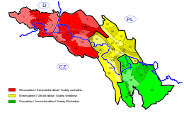
Suddivisioni


I Sudeti si dividono tradizionalmente in:
- Sudeti Orientali
- Monti Dorati
- Hrubý Jeseník (Alti Monti dei Frassini e Bassi Monti dei Frassini)
- Monti Opawskie
- Monti Śnieżnik
- Sudeti Centrali
- Monti Bardzkie
- Monti Bystrzyckie
- Monti Orlické
- Monti del Gufo
- Monti di Pietra
- Monti Tavola
- Sudeti Occidentali
- Dorsale Ještěd-Kozimmi
- Monti Iser
- Monti Kaczawskie
- Monti dei Giganti
- Monti lusaziani
- Rudawy Janowickie
- Altopiani lusaziani
- Sudeten Foreland
Voci correlate
- Sudetenland
Altri progetti
 Wikimedia Commons contiene immagini o altri file su Sudeti
Collegamenti esterni
- Sudeti, su Treccani.it – Enciclopedie on line, Istituto dell'Enciclopedia Italiana.
- sudeti, in Dizionario di storia, Istituto dell'Enciclopedia Italiana, 2010.
- Sudèti, su sapere.it, De Agostini.
- (EN) Sudeti, su Enciclopedia Britannica, Encyclopædia Britannica, Inc.
| Controllo di autorità | VIAF (EN) 239935387 · LCCN (EN) sh85129622 · GND (DE) 4118871-8 · BNF (FR) cb12050334m (data) · J9U (EN, HE) 987007543849205171 |
|---|
На других языках
[de] Sudeten
Die Sudeten (polnisch und tschech. Sudety) sind ein Gebirgszug in Deutschland, Tschechien und Polen. Sie bilden die nordöstliche Umrahmung des Böhmischen Beckens zwischen dem Elbsandsteingebirge und der Mährischen Pforte.[en] Sudetes
The Sudetes (/suːˈdiːtiːz/ soo-DEE-teez; Polish: Sudety; German: Sudeten; Czech: Krkonošsko-jesenická subprovincie), commonly known as the Sudeten Mountains, is a geomorphological subprovince in Central Europe, shared by Germany, Poland and the Czech Republic. They consist mainly of mountain ranges and are the highest part of Bohemian Massif. They stretch from the Saxon capital of Dresden in the northwest across to the region of Lower Silesia in Poland and to the Moravian Gate in the Czech Republic in the east. Geographically the Sudetes are a Mittelgebirge with some characteristics typical of high mountains.[1] Its plateaus and subtle summit relief makes the Sudetes more akin to mountains of Northern Europe than to the Alps.[1][es] Sudetes
Los Sudetes (en alemán, Sudeten, pronunciado /zuˈdeːtn̩/ ( escuchar); Sudety en checo y en polaco) son una cordillera de Europa central, que se extiende desde la ciudad alemana de Dresde (Sajonia), por el oeste, hasta la Puerta Morava (República Checa), por el este, incluyendo además una gran parte del voivodato de Baja Silesia (Polonia). Se dividen en tres secciones —Sudetes occidentales, Sudetes centrales y Sudetes orientales—, siendo su cumbre más alta el monte Sněžka (1603 m), en los Sudetes occidentales.[fr] Sudètes (montagne)
Les Sudètes (en allemand : Sudeten ; en tchèque et en polonais : Sudety ; nom complet en tchèque : Krkonošsko-jesenická subprovincie) sont une chaîne de montagnes d'Europe centrale, qui fait partie du massif de Bohême. Les Sudètes sont à cheval sur l'Allemagne à l'ouest, la Pologne au nord et la Tchéquie au sud, et forment la frontière entre ces deux derniers pays.- [it] Sudeti
[ru] Судеты
Суде́ты (польск. и чеш. Sudety, нем. Sudeten, чеш. Krkonošsko-jesenická subprovincie / Krkonošsko-jesenická soustava) — горы в Центральной Европе, на территории современных Германии, Польши и Чехии, протянувшиеся с северо-запада на юго-восток на 310 километров.Другой контент может иметь иную лицензию. Перед использованием материалов сайта WikiSort.org внимательно изучите правила лицензирования конкретных элементов наполнения сайта.
WikiSort.org - проект по пересортировке и дополнению контента Википедии