geo.wikisort.org - Montagne
Le San Gabriel Mountains sono una catena montuosa degli Stati Uniti d'America che occupa la parte settentrionale della contea di Los Angeles e quella occidentale della contea di San Bernardino in California.
| San Gabriel Mountains | |
|---|---|
 | |
| Continente | America settentrionale |
| Stati | USA |
| Catena principale | Catena Costiera Pacifica |
| Cima più elevata | Monte San Antonio (3.068 m s.l.m.) |
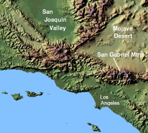
Forma una barriera tra la Greater Los Angeles Area e il deserto del Mojave ed è circondata dall'Angeles National Forest con la faglia di Sant'Andrea al confine settentrionale. Il picco più alto è il Monte San Antonio, comunemente denominato Mt. Baldy. Altra cima importante è il Monte Wilson, dove si trova l'osservatorio di Monte Wilson.
Il 13 ottobre 2014 fu dichiarato monumento nazionale dal presidente Barack Obama.
Altri progetti
 Wikimedia Commons contiene immagini o altri file su San Gabriel Mountains
Collegamenti esterni
- (EN) San Gabriel Mountains, su geonames.usgs.gov.
- (EN) Informazioni geologiche e geografiche della catena, su tchester.org.
| Controllo di autorità | VIAF (EN) 239189904 · LCCN (EN) sh85117099 · J9U (EN, HE) 987007553409905171 |
|---|
На других языках
[de] San Gabriel Mountains
Die San Gabriel Mountains sind ein Gebirgszug in Kalifornien. Als Teil der Transverse Ranges befinden sie sich im nördlichen Los Angeles County und im westlichen San Bernardino County.[en] San Gabriel Mountains
The San Gabriel Mountains (Spanish: Sierra de San Gabriel) are a mountain range located in northern Los Angeles County and western San Bernardino County, California, United States.[1] The mountain range is part of the Transverse Ranges and lies between the Los Angeles Basin and the Mojave Desert, with Interstate 5 to the west and Interstate 15 to the east. The range lies in, and is surrounded by, the Angeles and San Bernardino National Forests, with the San Andreas Fault as its northern border.[fr] Monts San Gabriel
Les monts San Gabriel sont situés au nord de Los Angeles, en Californie du Sud, aux États-Unis. Cette chaîne transversale forme une barrière entre la région du Grand Los Angeles et le désert des Mojaves. Cette chaîne côtière est recouverte par la forêt nationale d'Angeles. La faille de San Andreas la limite au nord. Son sommet le plus élevé est le mont San Antonio (en), ou mont Baldy. Le mont Wilson est un autre sommet, célèbre pour abriter l'observatoire du Mont Wilson.- [it] San Gabriel Mountains
[ru] Сан-Гейбриел (хребет)
Сан-Ге́йбриел[2] (англ. San Gabriel Mountains) — вдольширотная цепь гор в юго-западной части Калифорнии. Широтная, а не близмеридиональная ориентация гор Сан-Гейбриел связана с изгибом в разломе Сан-Андреас. Участки континентальной коры на тихоокеанской плите к западу от разлома Сан-Андреас на этом отрезке подвергаются сжатию и подъёму. Горы тектонически ограничены: на севере — разломом Сан-Андреас, на юге и юго-западе — взбросом, на востоке — разломом Сан-Хасинто.Текст в блоке "Читать" взят с сайта "Википедия" и доступен по лицензии Creative Commons Attribution-ShareAlike; в отдельных случаях могут действовать дополнительные условия.
Другой контент может иметь иную лицензию. Перед использованием материалов сайта WikiSort.org внимательно изучите правила лицензирования конкретных элементов наполнения сайта.
Другой контент может иметь иную лицензию. Перед использованием материалов сайта WikiSort.org внимательно изучите правила лицензирования конкретных элементов наполнения сайта.
2019-2026
WikiSort.org - проект по пересортировке и дополнению контента Википедии
WikiSort.org - проект по пересортировке и дополнению контента Википедии