geo.wikisort.org - Montagne
I Monti Tavola (in polacco: Góry Stołowe; in lingua ceca: Stolové hory; in tedesco: Heuscheuergebirge) sono una catena montuosa che fa parte dei Sudeti Centrali. Si estende per una lunghezza di circa 42 km nella regione di confine tra la Polonia e la Repubblica Ceca. Il settore polacco è incluso nel Parco nazionale dei Monti Tavola.[1]
| Monti Tavola | |
|---|---|
 | |
| Continente | Europa |
| Stati | |
| Catena principale | Sudeti Centrali |
| Cima più elevata | Szczeliniec Wielki (919 m s.l.m.) |
| Lunghezza | 42 km |
| Tipi di rocce | arenaria |
La vetta più elevata della catena montuosa è lo Szczeliniec Wielki, alto 919 metri.[2][3][4][5]
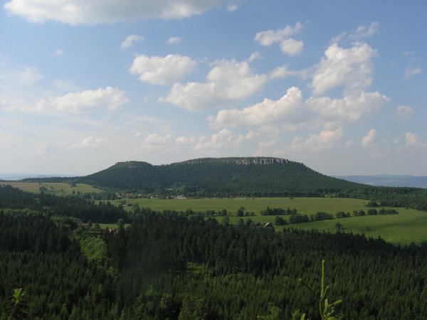
La caratteristica più rilevante dei Monti Tavola è la sua struttura fatta di arenaria disposta in strati orizzontali con una sommità totalmente piatta, unico caso in tutta la Polonia, il che conferisce alla catena montuosa il suo aspetto a forma di tavola (in polacco: Stołowe), da cui deriva il nome dei monti. I pendii laterali sono invece piuttosto scoscesi.[6]
Tra le attrazioni turistiche sono da segnalare i due massicci, Szczeliniec Wielki e Skalniak, sui quali si trovano alcune formazioni rocciose chiamate Błędne Skały (rocce erranti) caratterizzate da forme particolari che ricordano alcune immagini popolari: Kwoka (gallina), Wielbłąd (cammello), Małpa (scimmia), Głowa Konia (testa di cavallo), Fotel Pradziada (poltrona del nonno).
Foreste
Le foreste dei Monti Tavola sono dominate da monocolture di abete rosso piantati artificialmente, che hanno sostituito le foreste decidue e miste della parte inferiore che erano state abbattute in precedenza. Le foreste alluvionali sono le meno rappresentate. Le foreste decidue a latifoglie sono conservate solo in piccole aree in terreni di difficile accesso.[7]
Galleria d'immagini
 Lo Szczeliniec Wielki visto dal versante della Repubblica Ceca
 Panorama
 La poltrona del nonno sullo Szczeliniec Wielki
 Panorama
 Panorama
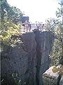 Veduta dalla galleria occidentale sullo Szczeliniec Wielki
 Punto di osservazione
 La scimmia sullo Szczeliniec Wielki
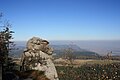 La scimmia
 Il Cammello sullo Szczeliniec Wielki
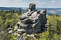 La testa di cavallo
 L' inferno
 L'albero cresciuto sulla roccia


Note
- Robert Brunner, Council of Europe. Committee for the Activities of the Council of Europe in the field of Biological and Landscape Diversity - 2002, pag. 15.
- (PL) Szczeliniec Wielki, su kudowa.zdroj.pl. URL consultato il 27 ottobre 2011 (archiviato dall'url originale il 26 agosto 2011).
- Poland - Page 147 Tomasz Torbus - 1999 "The Polish name means "table mountains" and accurately describes this unusual geological formation."
- Lonely Planet Poland - Page 344 Neal Bedford - 2008 "The Góry Stołowe (goo-ri sto-wo-veh), or 'Table Mountains', are among the most spectacular ranges of all the Sudetes. Lying roughly 10km northeast of Kudowa-Zdrój, they are almost as flat-topped as their name suggests."
- Rough Guide to Poland - Page 570 Mark Salter, Jonathan Bousfield - 2002 "Into the Gory stotowe Rising above 900m and almost as flat as their name suggests, the Gory Stolowe (Table Mountains) are not the most enticing range in the Klodzko region, but do have some extraordinary rock formations "
- Sudety and Przedgorze Sudeckie, su nature.poland.pl, Poland.pl. URL consultato il 27 ottobre 2011 (archiviato dall'url originale il 1º ottobre 2011).
- Marek Staffa (a cura di), Słownik geografii turystycznej Sudetów. V. 13: Góry Stołowe. Warszawa-Kraków: Wydawnictwo PTTK „Kraj”, 1992, p. 11–23. ISBN 83-7005-301-7.
Bibliografia
- Turistická Mapa: Broumovsko, Góry Kamienne a Stołowe, Klub Českých Turistů 1998, ISBN 80-85499-46-0
- Mapa Turystyczna: Góry Stołowe, PPWK 1989
Altri progetti
 Wikimedia Commons contiene immagini o altri file su Monti Tavola
| Controllo di autorità | VIAF (EN) 316741899 · LCCN (EN) sh85128253 · GND (DE) 4072481-5 |
|---|
На других языках
[de] Heuscheuergebirge
Das Heuscheuergebirge (polnisch Góry Stołowe, tschechisch Stolové hory, auch Hejšovina) ist ein Teil der Mittelsudeten in Polen. Es gehört zum Glatzer Kessel in Niederschlesien im westlichen Teil der ehemaligen Grafschaft Glatz. Im Westen und Norden grenzt es unmittelbar an Tschechien, wohin einige Ausläufer ausgreifen. Es steht als Nationalpark Góry Stołowe unter besonderem Schutz.[en] Stołowe Mountains
The Stołowe Mountains (Polish: [stɔˈwɔvɛ]; in English known as the Table Mountains, Polish: Góry Stołowe, Czech: Stolové hory, German: Heuscheuergebirge) are mountain range in Poland and the Czech Republic, part of the Central Sudetes. The Polish part of the range is protected as the Stołowe Mountains National Park.[1] The highest peak of the range is Szczeliniec Wielki at 919 metres (3,015 ft) a.s.l.[2][3][4][5][fr] Monts Tabulaires
Les monts Tabulaires, aussi appelés montagnes de la Table (en polonais Góry Stołowe, en tchèque Stolové hory, en allemand Heuscheuergebirge), sont une chaîne de montagne longue de 42 kilomètres et étendue sur la Pologne et la Tchéquie.- [it] Monti Tavola
Другой контент может иметь иную лицензию. Перед использованием материалов сайта WikiSort.org внимательно изучите правила лицензирования конкретных элементов наполнения сайта.
WikiSort.org - проект по пересортировке и дополнению контента Википедии