geo.wikisort.org - Montagne
I Monti Blu (in francese: Montagnes Bleus; in lingua tamasheq: Izouzaouene o Izouzaoenehe)[1] sono una catena montuosa del Niger situata nella parte nordorientale del massiccio dell'Aïr, circa 100 km a est-nordest del villaggio e oasi di Iférouane e 30 km a nordest dell'oasi di Tezerik.

Posizione geografica
I Monti Blu sono separati dalla porzione principale del massiccio dalle dune sabbiose dell'erg del Ténéré e da una spianata di deserto ghiaioso; rappresentano un affioramento roccioso che si innalza fino a 924 m, circa 300 m al di sopra della topografia circostante.[2]
I Monti Blu sono compresi all'interno dell'area della Riserva naturale Aïr-Ténéré, classificata come Patrimonio dell'umanità dall'UNESCO e recentemente sono stati inclusi nel Santuario dell'Addax dell'Aïr e Ténéré. Nonostante l'accessibilità non facile, erano diventati un'attrazione turistica durante il periodo di fioritura del turismo nigeriano nei tardi anni 1990 e all'inizio del 2000.
Geologia
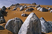
Da un punto di vista geologico sono caratterizzati dagli affioramenti di marmo cipollino formatisi sotto alte pressioni e temperatura da calcare di sedimenti oceanici.[3] Sono presenti anche intrusioni di altri minerali quali mica e serpentino che complessivamente danno una componente bluastra alla luce riflessa.[4]
È proprio questo luccichio bluastro contro la sabbia arancione del deserto che ha dato la denominazione a questi monti.[5]
Note
- Philippe Bourseiller, Sahara. Knesebeck Von Dem GmbH (2004) ISBN 978-3-89660-243-5
- Jolijn Geels, Niger, Chalfont St Peter, Bucks / Guilford, CT, Bradt UK / Globe Pequot Press, 2006, ISBN 978-1-84162-152-4. pp.178, 191–192.
- Dominique Auzias, Jean-Paul Labourdette, Niger, Paris, Petit Futé, 2009, p. 8, ISBN 978-2-7469-1640-1.
- Harald A. Friedl, Die Vertretbarkeit von Ethnotourismus am Beispiel der Tuareg der Region Agadez, Republik Niger (Westafrika) – Eine Evaluation aus Sicht der angewandten Tourismusethik. Dissertation, Graz, Karl-Franzens-Universität Graz, 2005, p. 219.
- Dominique Auzias, Jean-Paul Labourdette, Niger, Paris, Petit Futé, 2009, p. 187, ISBN 978-2-7469-1640-1.
Bibliografia
- Samuel Decalo, Historical Dictionary of the Niger (3rd ed.), Boston & Folkestone, Scarecrow Press, 1997, ISBN 0-8108-3136-8.
Voci correlate
- Aïr
- Riserva naturale Aïr-Ténéré
- Patrimonio dell'umanità
- Marmo cipollino
На других языках
[de] Blaue Berge (Niger)
Die Blauen Berge (französisch: Montagnes Bleues, Tuareg: Izouzadene oder Izouzaoenehe) sind ein bis zu 921 m hohes Vorgebirge des Aïr im Niger, das etwa 30 km ostnordöstlich der Ortschaft Iférouane liegt.[en] Blue Mountains (Niger)
The Blue Mountains (French: Montagnes Bleus, Tamasheq: Izouzaouene, Izouzaoenehe)[1] are an outcrop off the northeastern section of the Aïr Massif in Niger, about 100 km ENE of the town of Iférouane and 30 km NE of the Tezerik oasis. Isolated from the main massif by dunes of the Erg Temet and a flat gravelly desert pavement plain, the rocky outcrop from the desert rises to a height of 924m, almost 300m over the surrounding topography.[2] The area is in Aïr and Ténéré National Nature Reserve, which is a UNESCO World Heritage Site. The mountains themselves are also within the smaller Aïr and Ténéré Addax Sanctuary. They are characterised by cipollino marble outcroppings, which give the hills a bluish tint. Despite their relative remoteness, they became a tourist destination during the upsurge of desert tourism in the late 1990s and early 2000s.- [it] Monti Blu
Другой контент может иметь иную лицензию. Перед использованием материалов сайта WikiSort.org внимательно изучите правила лицензирования конкретных элементов наполнения сайта.
WikiSort.org - проект по пересортировке и дополнению контента Википедии