geo.wikisort.org - Montagne
La linea vulcanica del Camerun è una catena di vulcani lunga circa 1600 km.[1]

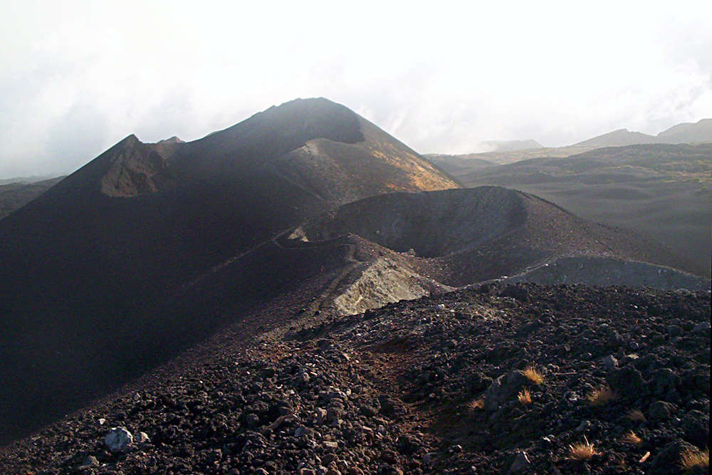
La linea include sia isole vulcaniche situate nel Golfo di Guinea, che una serie di montagne che si estendono lungo il confine tra Nigeria orientale e Camerun occidentale, dal Monte Camerun verso est fino al lago Ciad.
Le isole, che si trovano a cavallo dell'equatore, hanno clima tropicale e sono l'habitat di molte specie di piante e di uccelli unici. Le regioni montuose della terraferma sono molto più fresche delle pianure circostanti e sono pure sede di ambienti ecologici importanti e specifici.
La linea vulcanica del Camerun è piuttosto insolita dal punto di vista geologico in quanto si estende sia sulla crosta oceanica che su quella continentale. Sono state avanzate varie ipotesi per spiegare la sua formazione.[1][2]
Geografia
Nel Golfo di Guinea la linea del Camerun consiste di una serie di sei rilievi vulcanici che hanno formato delle montagne sottomarine o seamount. Da sudovest a nordest le isole sono Annobón, São Tomé, Príncipe e Bioko. Due grandi montagne sottomarine si trovano tra São Tomé e Príncipe, e tra Principe e Bioko.
Sulla terraferma, la linea inizia con il Monte Camerun e si estende verso nordest in una catena montuosa chiamata Alto plateau occidentale, dove crescono le foreste degli altopiani del Camerun. Altri vulcani dell'entroterra sono il Monte Manengouba, i Monti Bambouto e il Massiccio dell'Oku.[1] Nel Plateau di Ngaoundéré a est dei Monti Oku, ci sono altri rilievi vulcanici alcuni dei quali sembrano avere origine simile.[3]
Geologia
Non c'è un accordo completo tra i geologi su quali regioni vulcaniche dovrebbe essere incluse nella linea vulcanica del Camerun. Tutti includono la linea insulare e quella continentale fino ai Monti Oku. In base alle similarità di età e composizione, alcuni includono anche il Plateau di Ngaoundéré, il Plateau Biu in Nigeria fino a nord braccio di Yola della Valle di Benue e il Plateau Jos a ovest della valle di Benue.
Ci sono anche teorie diverse per spiegare la similarità tra i vulcani oceanici e quelli continentali.[4]
Note
- Burke, 2001.
- Foulger, p. 1 e seg.
- Marzoli, Piccirillo.
- Rankenburg, Lassiter.
Bibliografia
- African Bird Club, São Tomé e Príncipe, su africanbirdclub.org. URL consultato il 3 febbraio 2011 (archiviato dall'url originale il 24 dicembre 2010).
- Appleton, Annobon, in The new American cyclopaedia: a popular dictionary of general knowledge, Volume 1, 1857, p. 618.
- BBC, 1986: Hundreds gassed in Cameroon lake disaster, in BBC News, 21 agosto 1986. URL consultato il 1º febbraio 2011.
- Kathleen Becker, São Tomé and Príncipe, Bradt Travel Guides, 2008, ISBN 1-84162-216-8.
- Kevin Burke, Origin of the Cameroon Line of Volcano-Capped Swells (PDF), in The Journal of Geology, vol. 109, n. 3, 2001, pp. 349-362, Bibcode:2001JG....109..349B, DOI:10.1086/319977. URL consultato il 1º febbraio 2011.
- Conserving Afromontane Forest in the Bamenda Highlands of Cameroon, su birdlife.org, BirdLife International. URL consultato il 6 febbraio 2011 (archiviato dall'url originale il 14 dicembre 2010).
- C. Dorbath, L. Dorbath, D. Fairhead e G. W. Stuart, A teleseismic delay time study across the Central African Shear Zone in the Adamawa region of Cameroon, West Africa (PDF), in Geophys. J. R. Astron. Soc., 1986, pp. 751-766. URL consultato il 31 gennaio 2011 (archiviato dall'url originale il 7 agosto 2011).
- Equatorial Guinea, su cia.gov, CIA. URL consultato il 4 febbraio 2011 (archiviato dall'url originale il 31 agosto 2020).
- John E. Fa, Conservación de los ecosistemas forestales de Guinea Ecuatorial, IUCN, 1991, ISBN 2-88032-993-0.
- J. G. Fitton, The Cameroon line, West Africa: a comparison between oceanic and continental alkaline volcanism, in Special Publications, vol. 30, n. 1, Geological Society, London, 1987, pp. 273-291, Bibcode:1987GSLSP..30..273F, DOI:10.1144/GSL.SP.1987.030.01.13. URL consultato il 1º febbraio 2011.
- G.R. Foulger, Plates vs. Plumes: A Geological Controversy, Wiley-Blackwell, 2010, ISBN 978-1-4051-6148-0.
- Mathew Gwanfogbe, Ambrose Meligui, Jean Moukam e Jeanette Nguoghia, Geography of Cameroon, Hong Kong, Macmillan Education, 1983, ISBN 0-333-36690-5.
- H. Maluski, C. Coulon, M. Popoff e P. Baudin, 40Ar/39Ar chronology, petrology and geodynamic setting of Mesozoic to early Cenozoic magmatism from the Benue Trough, Nigeria, su jgs.lyellcollection.org, Geological Society of London, 1995.
- A. Marzoli, E. M. Piccirillo, P. R. Renne, G. Bellieni, M. Iacumin, J. B. Nyobe e A. T. Tongwa, The Cameroon Volcanic Line Revisited: Petrogenesis of Continental Basaltic Magmas from Lithospheric and Asthenospheric Mantle Sources, in Journal of Petrology, vol. 41, n. 1, 1999, pp. 87-109, DOI:10.1093/petrology/41.1.87. URL consultato il 1º febbraio 2011.
- R. W. McColl, Equatorial Guinea, in Encyclopedia of world geography, Volume 1, Infobase Publishing, 2005, ISBN 0-8160-5786-9.
- Donald G. McNeil Jr., Precursor to H.I.V. Was in Monkeys for Millenniums, in New York Times, 16 settembre 2010. URL consultato il 3 febbraio 2011.
- Mount Cameroon, su volcano.si.edu, Smithsonian. URL consultato il 1º febbraio 2011.
- Template:WWF ecoregion
- Aaron Neba, Modern Geography of the Republic of Cameroon, Bamenda, Neba Publishers, 1999.
- Information, Reed Business, Quake may have triggered Nyos disaster, in New Scientist, 12 febbraio 1987. URL consultato il 31 gennaio 2011.
- Emmanuel Njonfang, Alexandre Nono, Pierre Kamgang, Vincent Ngako e Tchoua Mbatcam, The Cameroon Line magmatism (Central Africa): A viewpoint, su cprm.gov.br, International Geological Congress, 2008. URL consultato il 1º febbraio 2011.
- N. G. Obaje, H. Wehner, M. B. Abubakar e M. T. Isah, NASARA-I WELL, GONGOLA BASIN (UPPER BENUE TROUGH, NIGERIA): SOURCE-ROCK EVALUATION, in Journal of Petroleum Geology, vol. 27, n. 2, aprile 2004, pp. 191-206, DOI:10.1111/j.1747-5457.2004.tb00053.x.
- C. O. Ofoegbu, A model for the tectonic evolution of the Benue Trough of Nigeria, in Geologische Rundschau, vol. 73, n. 3, 1984, pp. 1007-1018, Bibcode:1984GeoRu..73.1007O, DOI:10.1007/BF01820885. URL consultato il 14 marzo 2022 (archiviato dall'url originale il 3 febbraio 2013).
- S. W. Petters, Stratigraphic Evolution of the Benue Trough and Its Implications for the Upper Cretaceous Paleogeography of West Africa, in The Journal of Geology, vol. 86, n. 3, maggio 1978, pp. 311-322, Bibcode:1978JG.....86..311P, DOI:10.1086/649693, JSTOR 30061985.
- K. Rankenburg, J. C. Lassiter e G. Brey, The Role of Continental Crust and Lithospheric Mantle in the Genesis of Cameroon Volcanic Line Lavas: Constraints from Isotopic Variations in Lavas and Megacrysts from the Biu and Jos Plateaux, in Journal of Petrology, vol. 46, n. 1, 2004, pp. 169-190, DOI:10.1093/petrology/egh067. URL consultato il 2 febbraio 2011.
- San Carlos, su volcano.si.edu, Smithsonian. URL consultato il 4 febbraio 2011.
- Santa Isabel, su volcano.si.edu, Smithsonian. URL consultato il 4 febbraio 2011.
- San Joaquin, su volcano.si.edu, Smithsonian. URL consultato il 4 febbraio 2011.
- São Tomé and Principe Geography, in World Factbook, CIA. URL consultato il 6 gennaio 2018 (archiviato dall'url originale il 14 novembre 2017).
- Sao Tome, su volcano.si.edu, Smithsonian. URL consultato il 4 febbraio 2011.
- São Tomé and Príncipe (Background Note), su state.gov, US State Department, 7 dicembre 2010. URL consultato il 4 febbraio 2011.
- G. W. Stuart, J.D. Fairhead, L. Dorbath e C. Dorbath, CRUSTAL STRUCTURE OF THE ADAMAWA PLATEAU CAMEROON (PDF), in Rev. Sci. Et Tech. Sér Sci. Terre, 1985. URL consultato il 31 gennaio 2011.
- C Noutchogwe Tatchum, C T Tabod e E Manguelle-Dicoum, A gravity study of the crust beneath the Adamawa fault zone, west central Africa, in Journal of Geophysics and Engineering, vol. 3, n. 1, 2006, pp. 82-89, Bibcode:2006JGE.....3...82N, DOI:10.1088/1742-2132/3/1/009. URL consultato il 3 febbraio 2011.
Voci correlate
- Camerun
- Monte Camerun
| Controllo di autorità | GND (DE) 4501690-2 |
|---|
На других языках
[de] Kamerunlinie
Die Kamerunlinie (englisch Cameroon line) ist eine vulkanische Gebirgskette in Zentralafrika.[en] Cameroon line
The Cameroon line (French: Ligne du Cameroun, Portuguese: Linha dos Camarões, Spanish: cordillera de Camerún) is a 1,600 km (990 mi) chain of volcanoes.[1] It includes islands in the Gulf of Guinea and mountains that extend along the border region of eastern Nigeria and the West Region of Cameroon, from Mount Cameroon on the Gulf of Guinea north and east towards Lake Chad. The islands, which span the equator, have tropical climates and are home to many unique plant and bird species. The mainland mountain regions are much cooler than the surrounding lowlands, and also contain unique and ecologically important environments.[es] Cordillera de Camerún
La cordillera de Camerún es un grupo de macizos montañosos de África Occidental y Central. Se extiende a lo largo de la región fronteriza entre Nigeria y Camerún, desde el Monte Camerún en el Golfo de Guinea hasta el Lago Chad. La cordillera, que contiene muchos volcanes, activos y extintos, forma parte de la Dorsal del Camerún, que se extiende hacia el suroeste por el Golfo de Guinea e incluye las islas de Bioko, Annobón y Santo Tomé y Príncipe.[fr] Ligne du Cameroun
La ligne du Cameroun est un rift d'Afrique[1] s'étirant entre le bassin du lac Tchad et le golfe de Guinée dont elle trace une bissectrice[1].- [it] Linea vulcanica del Camerun
[ru] Камерунская линия
Камерунская линия — геологический разлом или рифтовая зона, которая тянется вдоль границы Восточной Нигерии и западного Камеруна, от горы Камерун на побережье Гвинейского залива на северо-восток, в сторону озера Чад. На ней расположена рифтовая долина Мбере. Линия характеризуется грядами горных хребтов и вулканов, известными как Камерунский хребет или Камерунские нагорья. Она была образована около 80 миллионов лет назад, при движении Африканской тектонической плиты против часовой стрелки. Через рифт открылись каналы магмы, что привело к образованию вулканов. Девять вулканов вдоль линии считаются активными: последнее извержение произошло в 2000 году на горе Камерун. Другие горы на гряде: горы Бамбоутус, гора Этинде, гора Маненгуба. Озеро Ньос — кратерное озеро, связанное с вулканизмом камерунской линии, расположено на северо-западе Камеруна. Рифт имеет продолжение в Атлантическом океане и образует острова Аннобон, Сур, Принсипи и Сан-Томе. Эти острова также иногда называются островами Гвинейского залива.Другой контент может иметь иную лицензию. Перед использованием материалов сайта WikiSort.org внимательно изучите правила лицензирования конкретных элементов наполнения сайта.
WikiSort.org - проект по пересортировке и дополнению контента Википедии