geo.wikisort.org - Montagne
La dorsale Saint Johns, spesso indicata come dorsale St. Johns, è una catena montuosa situata nella regione centro-occidentale della Dipendenza di Ross, sulla costa di Scott, in Antartide. La dorsale, che fa parte della catena delle montagne del Principe Alberto, ha la forma di una mezzaluna, con un'estremità volta a est e l'altra a nord-ovest, lunga circa 37 km, arrivando a una larghezza massima di circa 17 km, ed è costeggiata a sud e a ovest dalla valle Victoria, che la separa dalla dorsale Olympus, a nord dal ghiacciaio Cotton, che la separa dalla dorsale Clare, e a est dai ghiacciai Miller e Debenham, che la separano dalla dorsale Gonville and Caius. Dalle vette della dorsale, di cui la più alta è quella del monte Mahony, che arriva a 1870 m s.l.m., partono diversi ghiacciai, alcuni dei quali fluiscono verso sud arrivando quasi sul fondo della valle Victoria, è il caso ad esempio del Packard, e altri che fluiscono invece verso nord-ovest unendosi poi ai ghiacciai Miller e Debenham.[1]
| Dorsale Saint Johns | |
|---|---|
| Continente | Antartide |
| Stati | |
| Catena principale | Montagne del Principe Alberto |
| Cima più elevata | Monte Mahony (1 870 m s.l.m.) |
| Lunghezza | 37 km |
| Larghezza | 17 km |

Storia
La catena è stata scoperta nel corso della spedizione Discovery, condotta negli anni 1901-04 e comandata dal capitano Robert Falcon Scott, ma è stata così battezzata solo in seguito dai membri del reparto neozelandese della spedizione Fuchs-Hillary, condotta dal 1955 al 1958, in onore del college Saint John's di Cambridge, in Inghilterra, con cui molti dei membri della spedizione Terra Nova, condotta dal 1910 al 1913 e comandata dal capitano Robert Falcon Scott, pubblicarono i propri resoconti scientifici della spedizione.[2]
Mappe
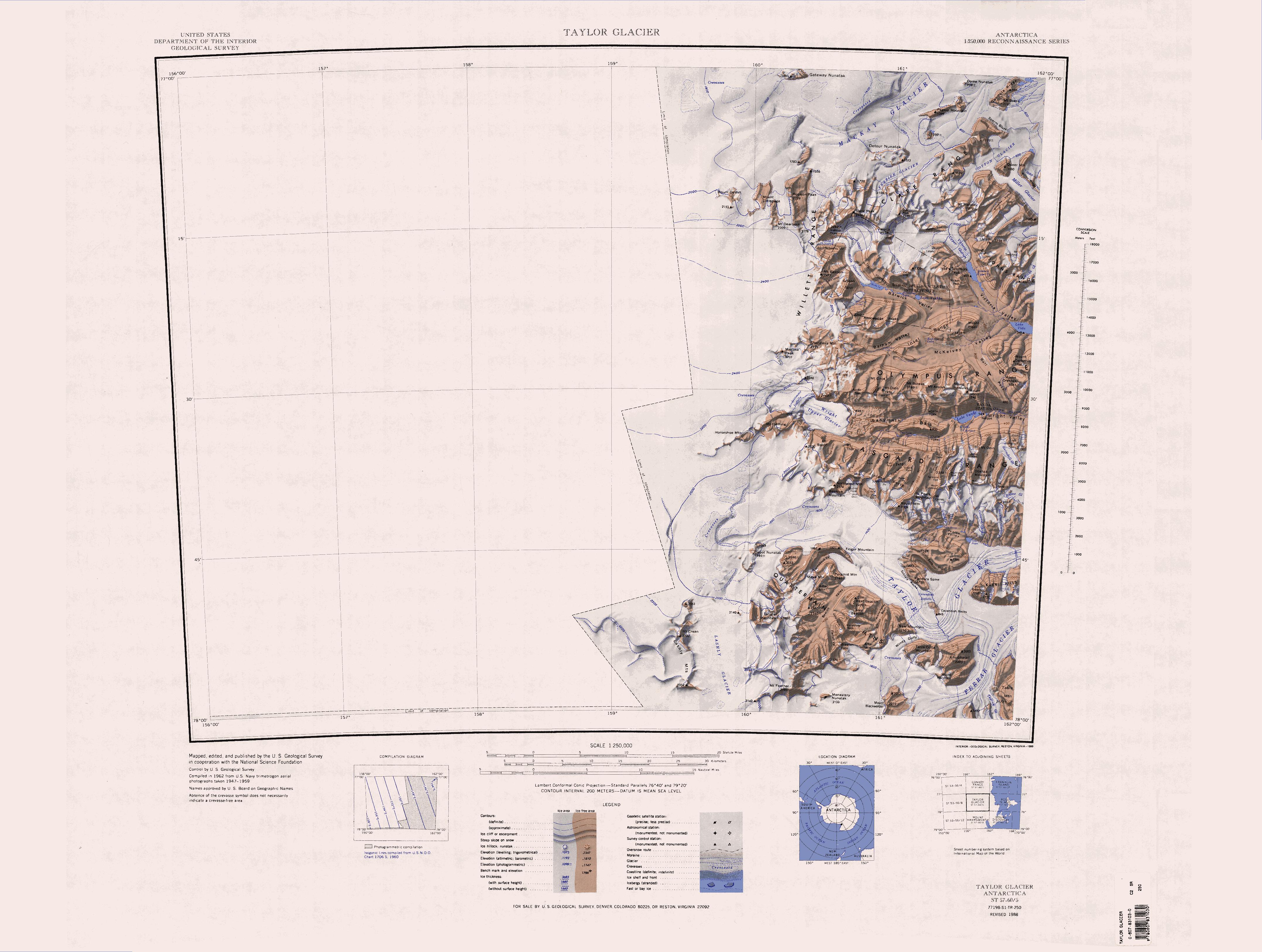
Di seguito una serie di mappe in scala 1:250 000 realizzate dallo USGS:
 Nella parte nord-orientale di questa mappa è possibile vedere la parte occidentale della dorsale Saint Johns.
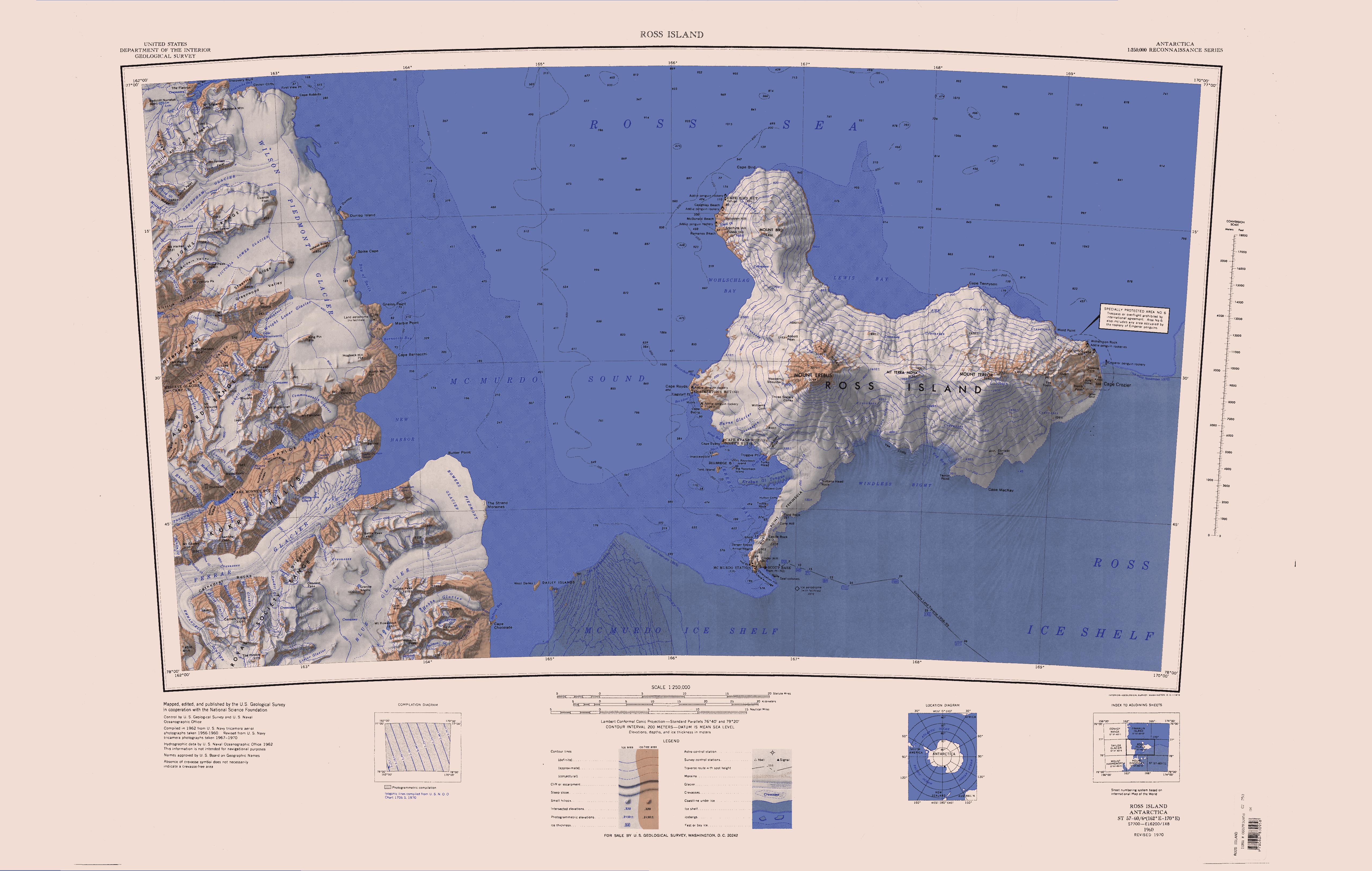
 Nella parte nord-occidentale di questa mappa è possibile vedere la parte orientale della dorsale Saint Johns.
Note
- Dorsale Saint Johns, su sws.geonames.org, GeoNames.Org (cc-by), 20 gennaio 2008. URL consultato il 27 aprile 2020.
- (EN) Dorsale Saint Johns, in Geographic Names Information System, USGS.
Voci correlate
Collegamenti esterni
- (EN) Dorsale Saint Johns, su Geographic Names Information System per l'Antartico, USGS.
На других языках
[de] Saint Johns Range
Die Saint Johns Range ist ein halbmondförmiger Gebirgszug im ostantarktischen Viktorialand. Er wird im Norden vom Cotton-, Miller- und Debenham-Gletscher begrenzt, im Süden vom Oberen und Unteren Victoria-Gletscher.[en] Saint Johns Range
Saint Johns Range (.mw-parser-output .geo-default,.mw-parser-output .geo-dms,.mw-parser-output .geo-dec{display:inline}.mw-parser-output .geo-nondefault,.mw-parser-output .geo-multi-punct{display:none}.mw-parser-output .longitude,.mw-parser-output .latitude{white-space:nowrap}77°17′S 162°0′E) is a crescent-shaped mountain range about 20 nautical miles (37 km) long, in Victoria Land. It is bounded on the north by the Cotton, Miller and Debenham Glaciers, and on the south by Victoria Valley and the Victoria Upper and Victoria Lower Glaciers. Its eastern end is formed by a spur called Lizards Foot. Named by the New Zealand Northern Survey Party of the Commonwealth Trans-Antarctic Expedition, 1956–58, which surveyed peaks in the range in 1957. Named for St. Johns College at Cambridge, England, with which several members of the British Antarctic Expedition (1910–13) were associated during the writing of their scientific reports, and in association with the adjacent Gonville and Caius Range.- [it] Dorsale Saint Johns
Другой контент может иметь иную лицензию. Перед использованием материалов сайта WikiSort.org внимательно изучите правила лицензирования конкретных элементов наполнения сайта.
WikiSort.org - проект по пересортировке и дополнению контента Википедии