geo.wikisort.org - Montagne
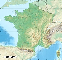
Capo Canaille è un promontorio della Francia meridionale, situato tra La Ciotat e i Calanchi, vicino Cassis. La roccia calcarea rossastra è composta da detritici. Con un'altezza di 399 metri sul livello del mare, e la più alta scogliera in Francia, ben più alta di quella di Étretat, nonché una delle più elevate dell'Europa continentale.
| Cap Canaille | |
|---|---|
 La sommità della scogliera è la più alta di Francia | |
| Stato | |
| Altezza | 399 m s.l.m. |
| Catena | Cap Canaille |
| Coordinate | 43°11′38.13″N 5°32′58.69″E |
| Mappa di localizzazione | |
 Cap Canaille | |
Il nome provenzale è Cap Naio. Cap Cannaille, il nome francese, è un errore di traduzione.
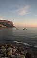 Cap Canaille vista dal porto di Cassis
 Cap Canaille vista con giardini


Voci correlate
- Parco nazionale dei Calanchi
Altri progetti
 Wikimedia Commons contiene immagini o altri file su Cap Canaille
Collegamenti esterni
- (FR) Cap Canaille sur NotreProvence.fr, su notreprovence.fr.
- (FR) Le Cap Canailles sur le site de l'Office de Tourisme de Cassis
- (FR) Le Cap Canaille en 360, su visit-cassis-360.com.
- (FR) Cap canaille vu en parapente, su parapentiste.info.
| Controllo di autorità | VIAF (EN) 127003648 · WorldCat Identities (EN) viaf-127003648 |
|---|
На других языках
[de] Cap Canaille
43.2166666666675.5388888888889[en] Cap Canaille
Cap Canaille is a headland situated in the Bouches-du-Rhône département, in southern France, on the Mediterranean Sea coast between the towns Cassis and La Ciotat and about 27 km (16 mi) from the centre of Marseille. At 394 m (1,293 ft), it is the highest sea cliff of France. The rock face of Cap Canaille is called Falaises de Soubeyrannes. The rock consists of layers of ochre-coloured sandstone, conglomerate and limestone from the Turonian age on top of grey marl from the Cenomanian until the Turonian age.[1] The Corniche des Crêtes road runs over the top of the cliff.- [it] Cap Canaille
Текст в блоке "Читать" взят с сайта "Википедия" и доступен по лицензии Creative Commons Attribution-ShareAlike; в отдельных случаях могут действовать дополнительные условия.
Другой контент может иметь иную лицензию. Перед использованием материалов сайта WikiSort.org внимательно изучите правила лицензирования конкретных элементов наполнения сайта.
Другой контент может иметь иную лицензию. Перед использованием материалов сайта WikiSort.org внимательно изучите правила лицензирования конкретных элементов наполнения сайта.
2019-2026
WikiSort.org - проект по пересортировке и дополнению контента Википедии
WikiSort.org - проект по пересортировке и дополнению контента Википедии