geo.wikisort.org - Montagne
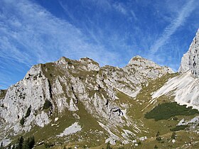
La Rote Flüh est une montagne qui s’élève à 2 108 m d’altitude dans les Alpes d'Allgäu, en Autriche.
| Rote Flüh | |||
 Vue depuis le sud-est. | |||
| Géographie | |||
|---|---|---|---|
| Altitude | 2 108 m[1] | ||
| Massif | Alpes d'Allgäu (Alpes) | ||
| Coordonnées | 47° 29′ 58″ nord, 10° 36′ 31″ est[1] | ||
| Administration | |||
| Pays | |||
| Land | Tyrol | ||
| District | Reutte | ||
| Géolocalisation sur la carte : Autriche
Géolocalisation sur la carte : Tyrol
| |||
| modifier |
|||
Notes et références
- (de) Cet article est partiellement ou en totalité issu de l’article de Wikipédia en allemand intitulé « Rote Flüh » (voir la liste des auteurs).
- Visualisation sur BEV.
Lien externe
- Portail de la montagne
- Portail des Alpes
- Portail de l'Autriche
На других языках
[de] Rote Flüh
Die Rote Flüh ist ein Berg in den Tannheimer Bergen, einer Untergruppe der Allgäuer Alpen. Sie ist 2108 m hoch. Die Rote Flüh besteht aus Wettersteinkalk. Seinen Namen hat der Berg wegen seiner schichtweisen Einsprengsel von rotem Kalkgestein, die bei Sonnenuntergang auffallend rötlich aufscheinen.[en] Rote Flüh
For the "Rote Flüh" feature on the North Face of the Eiger, see Eiger. The Rote Flüh is a peak in the Tannheim Mountains, a sub-range of the Allgäu Alps. It is 2,108 metres high. The Rote Flüh is built from Wetterstein limestone. It gets its name (which means "red rock face") from the layers of embedded particles of red limestone rock that appear reddish as the sun goes down.- [fr] Rote Flüh
Текст в блоке "Читать" взят с сайта "Википедия" и доступен по лицензии Creative Commons Attribution-ShareAlike; в отдельных случаях могут действовать дополнительные условия.
Другой контент может иметь иную лицензию. Перед использованием материалов сайта WikiSort.org внимательно изучите правила лицензирования конкретных элементов наполнения сайта.
Другой контент может иметь иную лицензию. Перед использованием материалов сайта WikiSort.org внимательно изучите правила лицензирования конкретных элементов наполнения сайта.
2019-2025
WikiSort.org - проект по пересортировке и дополнению контента Википедии
WikiSort.org - проект по пересортировке и дополнению контента Википедии

