geo.wikisort.org - Montagne
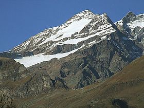
La pyramide Vincent est un sommet des Alpes situé à 4 215 m dans le mont Rose, à la frontière entre les régions italiennes de la Vallée d'Aoste et du Piémont. C'est le deuxième plus haut sommet des Alpes pennines entièrement situé en Italie après la tête Noire et le 4e du pays.
| Pyramide Vincent | |
 La pyramide Vincent vue du Valsesia. | |
| Géographie | |
|---|---|
| Altitude | 4 215 m[1],[2] |
| Massif | Mont Rose (Alpes pennines, Alpes) |
| Coordonnées | 45° 54′ 28″ nord, 7° 51′ 43″ est[1],[2] |
| Administration | |
| Pays | |
| Région Région à statut spécial |
Piémont Vallée d'Aoste |
| Province | Verceil |
| Ascension | |
| Première | , par Nicolas et Joseph Vincent de Gressoney-Saint-Jean[3] |
| Voie la plus facile | depuis le refuge Gnifetti (F) |
| Géologie | |
| Type | pic pyramidal |
| modifier |
|
Elle est l'un des sommets secondaires du massif du mont Rose. Elle se trouve au sud de la Ludwigshöhe, entourée par les glaciers du Lys (it) et de Piode (it).
Le sommet a été atteint avec succès le par les frères Nicolas (Johann Nikolaus) et Joseph Vincent de Gressoney-Saint-Jean, d'après lesquels le pic a été nommé.
La voie normale part de la cabane Giovanni Gnifetti au pied du glacier du Lys et est classé comme PD (Peu Difficile).
Notes et références
Voir aussi
- Classement des sommets des Alpes de plus de 4000 mètres
- Portail de la montagne
- Portail des Alpes
- Portail du Piémont
- Portail de la Vallée d'Aoste
На других языках
[de] Vincent-Pyramide
Die Vincent-Pyramide (walserdeutsch Vincentpiamid; italienisch Piramide Vincent, französisch Pyramide Vincent) ist ein 4215 m hoher Gipfel im südlichen Teil des Monte Rosa. Sie liegt knapp einen Kilometer südlich der italienisch-schweizerischen Grenze. Über dem Gipfel verläuft die Grenze zwischen Aostatal und Piemont. Der höchste Punkt der Pyramide bildet den östlichsten Punkt des Lysgletschers und südöstlich unterhalb verläuft in südwestlicher Ausrichtung der Indrengletscher. Sie wurde am 5. August 1819 durch Johann Nikolaus Vincent erstbestiegen, nach ihm wurde der Gipfel benannt.[en] Vincent Pyramid
The Vincent Pyramid (Walser German: Vincentpiramid, French: Pyramide Vincent, Italian: Piramide Vincent) (4,215 m (13,829 ft)) is a mountain of the Pennine Alps, located on the border between the Italian regions of Aosta Valley and Piedmont. The Vincent Pyramid makes up a large buttress of the huge multi-summited Monte Rosa. It lies south of the Ludwigshöhe on the border with Switzerland, between the Lysgletscher and the Piode Glacier. A seconday summit of the Vincent Pyramid, the Punta Giordani/Giordanispétz (4,046 m (13,274 ft)), lies to the southeast. Both Vincent Pyramid and Punta Giordani are on the official UIAA list of Alpine four-thousanders.- [fr] Pyramide Vincent
[it] Piramide Vincent
La Piramide Vincent (pron. fr. AFI: [vɛ̃sɑ̃] - Pyramide Vincent in francese, Vincentpiramid in Greschòneytitsch) (4.215 m s.l.m.) è una montagna del massiccio del Monte Rosa nelle Alpi Pennine.[ru] Пирамид-Винсент
Пирамид-Винсент (итал. Piramide Vincent, нем. Vincentpiramid) — вершина высотой 4215 метров над уровнем моря в массиве Монте-Роза в Пеннинских Альпах в Италии на границе регионов Пьемонт и Валле-д’Аоста. Первое восхождение на вершину Пирамид-Винсент совершили Иоганн Николус Винсент и Жак Кастель с двумя сопровождающими 5 августа 1819 года. В 1994 году UIAA включил Пирамид-Винсент в основной список официального перечня альпийских четырёхтысячников.Текст в блоке "Читать" взят с сайта "Википедия" и доступен по лицензии Creative Commons Attribution-ShareAlike; в отдельных случаях могут действовать дополнительные условия.
Другой контент может иметь иную лицензию. Перед использованием материалов сайта WikiSort.org внимательно изучите правила лицензирования конкретных элементов наполнения сайта.
Другой контент может иметь иную лицензию. Перед использованием материалов сайта WikiSort.org внимательно изучите правила лицензирования конкретных элементов наполнения сайта.
2019-2025
WikiSort.org - проект по пересортировке и дополнению контента Википедии
WikiSort.org - проект по пересортировке и дополнению контента Википедии


