geo.wikisort.org - Montagne
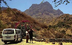
Le Pico da Antónia est une montagne du Cap-Vert, d'origine volcanique. C'est le point culminant de l'île de Santiago.
| Pico da Antónia | ||
 Vue sur le Pico da Antónia. | ||
| Géographie | ||
|---|---|---|
| Altitude | 1 394 m | |
| Massif | Santiago | |
| Coordonnées | 15° 03′ 04″ nord, 23° 38′ 10″ ouest | |
| Administration | ||
| Pays | ||
| Géologie | ||
| Type | Volcan de point chaud | |
| Activité | Éteint | |
| Dernière éruption | Inconnue | |
| Code GVP | Aucun | |
| Géolocalisation sur la carte : Cap-Vert
| ||
| modifier |
||
Le site est protégé par le parc naturel du Rui Vaz et Serra de Pico de Antónia.
Annexes
Article connexe
Bibliographie
- (en) Ricardo A. S. Ramalho, « The Pico da Antónia Volcanic Complex », in Building the Cape Verde Islands, Springer, 2011, p. 106-110 (ISBN 9783642191022)
Liens externes
- (en) Serra do Pico da Antónia (BirdLife International)
- (pt) Áreas protegidas, Cabo Verde
- Portail de la montagne
- Portail du volcanisme
- Portail du Cap-Vert
На других языках
[en] Pico de Antónia
Pico de Antónia is a mountain located in the central part of the island of Santiago in Cape Verde. At 1,392 m (4,567 ft), it is the highest point of the island.[1] The mountain is part of the protected area Parque Natural da Serra do Pico de Antónia.[2][3] The towns Picos and Assomada lie close to the mountain. The Serra do Pico da Antónia has been identified by BirdLife International as an Important Bird Area.[4]- [fr] Pico da Antónia
Текст в блоке "Читать" взят с сайта "Википедия" и доступен по лицензии Creative Commons Attribution-ShareAlike; в отдельных случаях могут действовать дополнительные условия.
Другой контент может иметь иную лицензию. Перед использованием материалов сайта WikiSort.org внимательно изучите правила лицензирования конкретных элементов наполнения сайта.
Другой контент может иметь иную лицензию. Перед использованием материалов сайта WikiSort.org внимательно изучите правила лицензирования конкретных элементов наполнения сайта.
2019-2025
WikiSort.org - проект по пересортировке и дополнению контента Википедии
WikiSort.org - проект по пересортировке и дополнению контента Википедии
