geo.wikisort.org - Montagne
Le pic Gannett (Gannett Peak en anglais) est le plus haut sommet de l'État américain du Wyoming. Il s'étend sur les comtés de Fremont et de Sublette le long du Continental Divide.
Cet article est une ébauche concernant la montagne et le Wyoming.
Vous pouvez partager vos connaissances en l’améliorant (comment ?) selon les recommandations des projets correspondants.
| Pic Gannett | |||
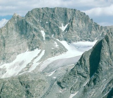 Versant occidental du Pic Gannet à partir de Bridger-Teton National Forest | |||
| Géographie | |||
|---|---|---|---|
| Altitude | 4 207 m[1] | ||
| Massif | Chaîne de Wind River (montagnes Rocheuses) |
||
| Coordonnées | 43° 11′ 04″ nord, 109° 39′ 15″ ouest[1] | ||
| Administration | |||
| Pays | |||
| État | Wyoming | ||
| Comtés | Fremont, Sublette | ||
| Ascension | |||
| Première | A. Tate and F. Stahlnaker en 1922 | ||
| Géolocalisation sur la carte : Wyoming
Géolocalisation sur la carte : États-Unis
| |||
| modifier |
|||


Nommé en 1906[2] en hommage au géographe américain Henry Gannett et escaladé pour la première fois en 1922, le pic est aussi le point culminant de la chaîne de Wind River. Les versants de la montagne se situent dans les forêts nationales de Bridger-Teton et Shoshone. Il est le point culminant du Greater Yellowstone Ecosystem. Le glacier Gannet (3.63 km²) qui est le plus grand glacier simple des Montagnes Rocheuses s'étend sur le versant nord de la montagne. Le Minor Glacier se situe sur le versant occidental, les Dinwoody Glacier et Gooseneck Glacier au sud-est.
Il faut entre 4 et 6 jours pour escalader le pic aller-retour. Il est par ailleurs considéré chez les grimpeurs comme le deuxième pic le plus difficile à escalader du pays après le Denali en Alaska. Certains grimpeurs le classent aussi après le Granite Peak qui a seulement été escaladé en 1923.

Liens externes
- Notices dans des dictionnaires ou encyclopédies généralistes :
- Ressources relatives à la géographie :
- (en) Gannett Peak
Références
 Portail de la montagne
  Portail du Wyoming
На других языках
[de] Gannett Peak
Der Gannett Peak ist mit 4207 Metern Höhe die höchste Erhebung im US-Bundesstaat Wyoming.[en] Gannett Peak
Gannett Peak[5] is the highest mountain peak in the U.S. state of Wyoming at 13,810 feet (4,210 m). It lies in the Wind River Range within the Bridger Wilderness of the Bridger-Teton National Forest. Straddling the Continental Divide along the boundary between Fremont and Sublette counties, it has the second greatest topographic prominence in the state (7076') after Cloud Peak (7077'), and is the highest ground for 290.36 miles (467.29 kilometers) in any direction.- [fr] Pic Gannett
[ru] Ганнетт-Пик
Ганнетт-Пик[2], Га́ннет-Пик[3] (англ. Gannett Peak) — горная вершина в Вайоминге (США).Другой контент может иметь иную лицензию. Перед использованием материалов сайта WikiSort.org внимательно изучите правила лицензирования конкретных элементов наполнения сайта.
WikiSort.org - проект по пересортировке и дополнению контента Википедии