geo.wikisort.org - Montagne
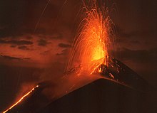
Le Pacaya est un volcan actif de 2 552 mètres d'altitude situé en périphérie de la ville d'Antigua, au Guatemala. Il entra en éruption pour la première fois il y a environ 23 000 ans et, depuis l'arrivée des Espagnols, il est entré en éruption au moins vingt-trois fois.
| Pacaya | |
 Vue du Pacaya. | |
| Géographie | |
|---|---|
| Altitude | 2 552 m |
| Massif | Sierra Madre du Chiapas |
| Coordonnées | 14° 22′ 52″ nord, 90° 36′ 04″ ouest |
| Administration | |
| Pays | |
| Département | Escuintla |
| Géologie | |
| Âge | 23 000 ans |
| Type | Volcan de subduction |
| Morphologie | Stratovolcan |
| Activité | En éruption |
| Dernière éruption | Depuis le |
| Code GVP | 342110 |
| Observatoire | Instituto Nacional de Sismologia, Vulcanologia, Meteorologia y Hidrologia |
| modifier |
|
Après être resté endormi durant près d'un siècle, il entra violemment en éruption en 1961 ; depuis, son activité est relativement constante. Le Pacaya est entré à nouveau dans une phase éruptive du au , projetant de la lave, des fumées et des cendres, qui se sont élevées jusqu'à 1 000 mètres.

Lien externe
- Portail de la montagne
- Portail du volcanisme
- Portail du Guatemala
На других языках
[de] Pacaya
Der Pacaya ist einer der aktivsten Vulkane der Welt. Er liegt südlich von Guatemala-Stadt, seine Eruptionen können meistens von dort beobachtet werden. Während der spanischen Kolonialzeit wurden insgesamt 23 Ausbrüche registriert. Danach ruhte die Tätigkeit ungefähr ein Jahrhundert, bis es im Jahr 1965 wieder zu einem heftigen Ausbruch kam. Seit dieser Zeit besteht eine kontinuierliche Aktivität. Die Eruptionen sind in der Regel strombolianisch mit Hunderten von täglichen Explosionen. Die strombolianischen Eruptionen werden durch Entgasung des Magma ausgelöst, sie schleudern glühende Lavabomben oft Hunderte Meter in die Luft und produzieren auch kleinere ʻAʻā-Lavaströme. Sporadisch produziert Pacaya auch mäßige plinianische Eruptionen.[en] Pacaya
Pacaya is an active complex volcano in Guatemala, which first erupted approximately 23,000 years ago and has erupted at least 23 times since the Spanish conquest of Guatemala. It rises to an elevation of 2,552 metres (8,373 ft).[1] After being dormant for over 70 years, it began erupting vigorously in 1961 and has been erupting frequently since then. Much of its activity is Strombolian, but occasional Plinian eruptions also occur, sometimes showering the area of the nearby Departments with ash.[1][es] Volcán de Pacaya
El Volcán de Pacaya es un volcán activo ubicado en el municipio de Amatitlán en el departamento de Guatemala y el municipio de San Vicente Pacaya en el departamento de Escuintla, Guatemala.- [fr] Pacaya
[ru] Пакая
Пака́я (исп. Pacaya) — действующий вулкан на территории Гватемалы, один из активнейших вулканов на планете.Текст в блоке "Читать" взят с сайта "Википедия" и доступен по лицензии Creative Commons Attribution-ShareAlike; в отдельных случаях могут действовать дополнительные условия.
Другой контент может иметь иную лицензию. Перед использованием материалов сайта WikiSort.org внимательно изучите правила лицензирования конкретных элементов наполнения сайта.
Другой контент может иметь иную лицензию. Перед использованием материалов сайта WikiSort.org внимательно изучите правила лицензирования конкретных элементов наполнения сайта.
2019-2025
WikiSort.org - проект по пересортировке и дополнению контента Википедии
WikiSort.org - проект по пересортировке и дополнению контента Википедии
