geo.wikisort.org - Montagne
La Mrzla gora est un sommet des Alpes, à 2 203 m, dans les Alpes kamniques, entre l'Autriche et la Slovénie.
| Mrzla gora | ||||
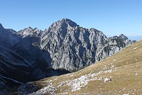
 Vue de la face sud du Mrzla gora depuis Kamniško sedlo. | ||||
| Géographie | ||||
|---|---|---|---|---|
| Altitude | 2 203 m[1],[2] | |||
| Massif | Alpes kamniques (Alpes) | |||
| Coordonnées | 46° 22′ 38″ nord, 14° 34′ 41″ est[1],[2] | |||
| Administration | ||||
| Pays | ||||
| Land Région historique |
Carinthie Basse-Styrie |
|||
| District Commune |
Völkermarkt Solčava |
|||
| Ascension | ||||
| Première | 1877 par J. Frischauf, Matek et J. Piskernik | |||
| Voie la plus facile | Sud-ouest | |||
| Géologie | ||||
| Âge | 250 millions d'années (roche) | |||
| Roches | Calcaire | |||
| Géolocalisation sur la carte : Autriche
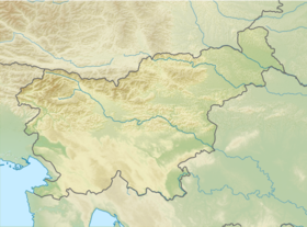
Géolocalisation sur la carte : Slovénie
Géolocalisation sur la carte : Carinthie
| ||||
| modifier |
||||
Le versant sud et son prolongement vers l'est forment la rive gauche de la vallée de Logarska dolina où se trouve la source de la Savinja ainsi que la chute d'eau slap Rinka.
Le versant nord-est se présente en fin de la vallée Matkov kot. Cette vallée et son cours d'eau Jezera est le premier affluent rive gauche de la Savinja.
La crête nord et son prolongement vers le nord (notamment Krnička gora 2 064 m et Matkova Kopa 1 957 m) séparent les vallées Matkov kot et Vellacher Kotschna / Belska Kočna, formant une ligne de partage des eaux (Save / Drave). Le col, au faîte des vallées Logarska dolina et Vellacher Kotschna / Belska Kočna, s'appelle Savinjsko sedlo / Sannthaler Sattel.
Le versant nord-ouest forme le début de la rive droite de la vallée Vellacher Kotschna / Belska Kočna et de son cours d'eau Vellach / Bela.
Frischauf, Matek et Piskernik ouvrirent ce « dernier grand problème » des Alpes kamniques en 1877, par la voie nord-est.
Accès
La voie normale, la plus ardue du massif, est au départ du refuge Frischaufov dom (Okrešelj). Elle remonte la vallée en direction du col Savinjsko sedlo / Sannthaler Sattel puis rejoint le sommet par la crête sud-ouest.
Sources
- (sl) Silvo Babič, Tone Golnar, Plezalni vodnik Logarska dolina - zahodni del, Ljubljana, Planinska zveza Slovenije, (ISBN 961-6156-18-7). -guide d'alpinisme pour Logarska dolina, partie occidentale (Club alpin slovène).
- (sl) Tine Mihelič, Rudi Zaman, Slovenske stene, Radovljica, Didakta, (ISBN 961-6463-47-0). -guide d'alpinisme et livre reconnu, couvrant les parois slovènes.
- (sl) Vladimir Habjan, Jože Drab... et al., Kamniško-Savinjske Alpe : planinski vodnik, Ljubljana, Planinska zveza Slovenije, (ISBN 961-6156-52-7). -guide de randonnée alpine pour les Alpes kamniques (Club alpin slovène).
- PzS (N° 266), GzS, Grintovci - 1 : 25 000[3], Ljubljana, 2005. -carte du Club alpin slovène.
Notes et références
- Visualisation sur BEV.
- Visualisation sur le géoportail de la Slovénie.
- L'appellation Grintovci pour le massif des Alpes kamniques vient du nom de son point culminant, le Grintovec. Cette dénomination évite le titre à double nom : Kamniško-Savinjske Alpe.
- Portail de la montagne
- Portail des Alpes
- Portail de la Slovénie
На других языках
[de] Mrzla gora
Die Mrzla gora (deutsch auch Mrzla Gora geschrieben, oder Merzlagora, wörtlich übersetzt ‚Kalter Berg‘) ist ein 2203 m ü. A.[1] hoher Berg in den Steiner Alpen an der Grenze von Kärnten und Slowenien.[en] Cold Mountain (Slovenia)
Cold Mountain (Slovene: Mrzla gora)[1] is a 2,203-meter (7,228 ft) mountain in the Kamnik Alps. Cold Mountain rises over three valleys: the Logar Valley, the Matk Cirque (Slovene: Matkov kot), and the Vellach Combe (German: Vellacher Kotschna, Slovene: Belska kočna). It is rarely visited because it is relatively difficult to ascend with many exposed areas. The border with Austria runs along the northern and western side, and until 1967 it was difficult to access because of political problems. Its first climbers had problems scaling it. In 1876, Robert von Lendenfeld and a guide named Matijevec from Luče reached the western peak and they descended, thinking they had reached the highest peak. In 1877, Karl Blodig (the first to climb every peak over 4,000 meters or 13,000 feet in Europe) tried two times, but quit due to weather well below the top. In the same year Johannes Frischauf, Piskernik, and Matek finally conquered the top. The Frischauf Lodge on Okrešelj is named after him.- [fr] Mrzla gora
Другой контент может иметь иную лицензию. Перед использованием материалов сайта WikiSort.org внимательно изучите правила лицензирования конкретных элементов наполнения сайта.
WikiSort.org - проект по пересортировке и дополнению контента Википедии


