geo.wikisort.org - Montagne
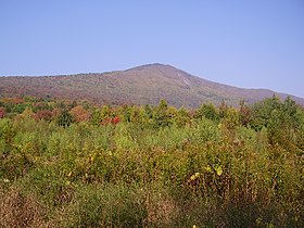
Le mont Greylock (1 063 m) est le point culminant de l'État du Massachusetts. Un mémorial se trouve à son sommet.

| Mont Greylock | |||
 Le mont Greylock depuis la West Mountain Road | |||
| Géographie | |||
|---|---|---|---|
| Altitude | 1 063 m[1] | ||
| Massif | Appalaches | ||
| Coordonnées | 42° 38′ 15″ nord, 73° 10′ 00″ ouest[1] | ||
| Administration | |||
| Pays | |||
| État | Massachusetts | ||
| Comté | Berkshire | ||
| Ascension | |||
| Voie la plus facile | route | ||
| Géolocalisation sur la carte : Massachusetts
Géolocalisation sur la carte : États-Unis
| |||
| modifier |
|||
Notes et références
- Visualisation sur l'USGS.
Liens externes
- Ressources relatives à la géographie :
- Portail de la montagne
- Portail du Registre national des lieux historiques
- Portail du Massachusetts
На других языках
[de] Mount Greylock
Der Mount Greylock ist mit 3.491 ft (1.064,1 m) die höchste natürliche Erhebung im Bundesstaat Massachusetts der Vereinigten Staaten. Er gehört geologisch zu den Taconic Mountains im Nordwesten von Massachusetts, wird aber üblicherweise mit den südlich angrenzenden Berkshire Mountains in Verbindung gebracht. Auf dem Gipfel befindet sich ein 1931/32 errichteter, 28 Meter hoher leuchtturmähnlicher Gedenkturm für Massachusetts’ Kriegsveteranen seit dem Ersten Weltkrieg.[en] Mount Greylock
Mount Greylock is a 3,489-foot (1,063-meter) mountain located in the northwest corner of Massachusetts and is the highest point in the state. Its summit is in the western part of the town of Adams (near its border with Williamstown) in Berkshire County. Technically, Mount Greylock is geologically part of the Taconic Mountains, which are not associated with the abutting Berkshire Mountains to the east. The mountain is known for its expansive views encompassing five states and the only taiga-boreal forest in the state. A seasonal automobile road (open annually from late May through November 1) climbs to the summit, topped by a 93-foot-high (28 m) lighthouse-like Massachusetts Veterans War Memorial Tower. A network of hiking trails traverses the mountain, including the Appalachian Trail. Mount Greylock State Reservation was created in 1898 as Massachusetts' first public land for the purpose of forest preservation.[9]- [fr] Mont Greylock
[it] Monte Greylock
Il monte Greylock è il punto più elevato (1064 m) dello Stato USA del Massachusetts. È situato 8 km a sud/sud-ovest di North Adams, sulle Berkshire Hills. I visitatori possono accedere tramite una strada o, se si tratta di escursionisti, il Sentiero degli Appalachi fino alla cima, dove sorge una torre-faro di granito alta 28 m costruita nel 1932 come memoriale per le vittime della guerra. La cima, pianeggiante, ricade entro i confini della Mount Greylock State Reservation ed è popolare presso gli amanti degli sport invernali. Il Bascom Lodge (1937), posto sulla sommità, è aperto in estate ed autunno. Il nome Greylock è quello di un capo indiano della tribù dei Waranoke vissuto ai primi del XVIII secolo.[ru] Грейлок
Грейлок (англ. Mount Greylock) — гора в хребте Беркширы в округе Беркшир на западе штата Массачусетс.Текст в блоке "Читать" взят с сайта "Википедия" и доступен по лицензии Creative Commons Attribution-ShareAlike; в отдельных случаях могут действовать дополнительные условия.
Другой контент может иметь иную лицензию. Перед использованием материалов сайта WikiSort.org внимательно изучите правила лицензирования конкретных элементов наполнения сайта.
Другой контент может иметь иную лицензию. Перед использованием материалов сайта WikiSort.org внимательно изучите правила лицензирования конкретных элементов наполнения сайта.
2019-2025
WikiSort.org - проект по пересортировке и дополнению контента Википедии
WikiSort.org - проект по пересортировке и дополнению контента Википедии

