geo.wikisort.org - Montagne
Le mont Cleveland est la plus haute montagne située dans le parc national de Glacier dans l'État du Montana aux États-Unis. C'est également le point culminant du chaînon Lewis. La montagne est située à environ 8 km au sud de la frontière avec le Canada[2],[1].
Pour les articles homonymes, voir Cleveland (homonymie).
Cet article est une ébauche concernant la montagne et le parc national de Glacier.
Vous pouvez partager vos connaissances en l’améliorant (comment ?) selon les recommandations des projets correspondants.
| Mont Cleveland | |||
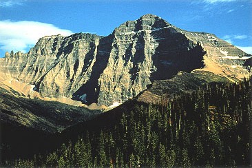 Vue du mont Cleveland. | |||
| Géographie | |||
|---|---|---|---|
| Altitude | 3 190 m[1] | ||
| Massif | Chaînon Lewis (montagnes Rocheuses) | ||
| Coordonnées | 48° 55′ 29″ nord, 113° 50′ 53″ ouest[1] | ||
| Administration | |||
| Pays | |||
| État | Montana | ||
| Comté | Glacier | ||
| Ascension | |||
| Première | 1924 par Stimson | ||
| Géolocalisation sur la carte : Montana
Géolocalisation sur la carte : États-Unis
| |||
| modifier |
|||


Le mont se caractérise par un fort dénivelé par rapport à la vallée environnante. Son versant occidental grimpe de plus de 1 700 mètres sur 3,2 km et son versant nord-ouest s’élève de 1 200 mètres en à peine 640 mètres. Il fait ainsi partie des montagnes les plus pentues des États-Unis[3],[4]. Sa première ascension fut réussie en 1924 par le Sierra Club. La route d’accès la plus facile se fait par la face occidentale. Des traces laissent à penser que des indiens avaient déjà escaladé la montagne avant l'arrivée des européens.
Annexes
Bibliographie
- J. Gordon Edwards, A Climber's Guide to Glacier National Park, Falcon Press, 1995.
Liens externes
- Ressources relatives à la géographie :
Notes et références
- Visualisation sur l'USGS.
- (en) « Mount Cleveland, Montana », Peakbagger (consulté le )
- (en) « List of the peaks in the contiguous US » (consulté le )
- (en) Maizlish Aaron, Edward Earl, Andy Martin, John Roper, David Olson, Ken Jones, Ron Tagliapietra, « AMERICA'S 57 - the Ultras », peaklist.org (consulté le )
 Portail de la montagne
  Portail du Montana
На других языках
[en] Mount Cleveland (Montana)
Mount Cleveland is the highest mountain in Glacier National Park, located in Montana, United States.[3] It is also the highest point in the Lewis Range, which spans part of the northern portion of the park and extends into Canada. It is located approximately 3 mi (4.8 km) southeast of the southern end of Waterton Lake, and approximately 5 mi (8.0 km) south of the US–Canada border. The east side of the future national park was purchased by the federal government from the Blackfoot Confederacy in 1895 during the second term of President Grover Cleveland. According to the United States Board on Geographic Names, the mountain is named for the former president.- [fr] Mont Cleveland (Montana)
Другой контент может иметь иную лицензию. Перед использованием материалов сайта WikiSort.org внимательно изучите правила лицензирования конкретных элементов наполнения сайта.
WikiSort.org - проект по пересортировке и дополнению контента Википедии