geo.wikisort.org - Montagne
Le Lapche Kang ou Labuche Kang ou Choksam est une montagne culminant à 7 367 mètres dans la Région autonome du Tibet, en Chine.
| Lapche Kang | |||
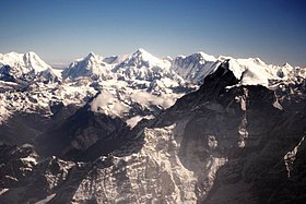
 Le Lapche Kang, au centre, avec le Lapche Kang W à gauche et le Lapche Kang II à droite (avec le Gauri Sankar au premier plan à droite). | |||
| Géographie | |||
|---|---|---|---|
| Altitude | 7 367 m[1] | ||
| Massif | Chaîne du Lapchi Kang (Himalaya) | ||
| Coordonnées | 28° 18′ 15″ nord, 86° 21′ 03″ est[1] | ||
| Administration | |||
| Pays | |||
| Région autonome | Tibet | ||
| Ville-préfecture | Shigatsé | ||
| Ascension | |||
| Première | par Hidekatsu Furukawa, Keiichi Sudo, Osamu Tanabe, Ataru Deuchi, avec Wanjia, Diaqiog, Gyala et Lhaji | ||
| Voie la plus facile | Arête ouest | ||
| Géolocalisation sur la carte : région autonome du Tibet
Géolocalisation sur la carte : Chine
| |||
| modifier |
|||
Sommets secondaires
Il présente plusieurs sommets secondaires :
- le Lapche Kang II (ou Lapche Kang III[2]), à 7 250 mètres à 3 km à l'est du sommet principal. Avec 570 m de proéminence, c'est le plus haut sommet vierge dont l'ascension est autorisée et dont la proéminence est supérieure à 500 m. Une expédition polonaise composée de Krzysztof Mularski, Maciej Przebitkowski, Jakub Rybicki et Jarosław Żurawski a atteint l'altitude de 6 900 m par l'éperon Est et la face Sud-Est en [3] ;
- le Lapche Kang W (ou Lapche Kang II[2]), 7 072 mètres, à 2,5 km à l'ouest du sommet principal, gravi le par une expédition suisse ;
- le Lapche Kang II Est, 7 040 mètres, vierge ;
- le Lapche Kang II ENE, 6 980 m vierge ;
- le Lapche Kang NW, 6 897 m, vierge ;
- le Gyao Kang, 6 718 m, gravi le par une expédition française.
Ascensions
La première ascension a été réussie le par une expédition sino-japonaise composée des Japonais Hidekatsu Furukawa, Keiichi Sudo, Osamu Tanabe, Ataru Deuchi et des Tibétains Wanjia, Diaqiog, Gyala et Lhaji, par l'arête W[4]. L'alpiniste américain Joseph Puryear meurt lors d'une tentative d'ascension le en passant à travers une corniche[5].
Notes et références
- (en) [PDF] Eberhard Jurgalski High Asia - All mountains and main peaks above 6650 m, 12 août 2019
- (en) Labuche Kang, China, peakbagger.com
- (en) « Lapche Kang II, East Spur and Southeast Face, Attempt », American Alpine Journal, 2017
- (en) « Asia, Tibet, Labuche Kung », American Alpine Journal, 1988, p. 279
- (en) « In memoriam: Joseph Nicholi Puryear, 1972-2010 », American Alpine Journal, 2011, p. 380
Voir aussi
Articles connexes
- Plus haut sommet vierge
- Géographie de la Chine
- Géographie du Tibet
Liens externes
- Lapche Kang, les montagnes de Milarepa sur le site du guide Paulo Grobel
- Portail de la montagne
- Portail du Tibet
- Portail de l’alpinisme et de l’escalade
На других языках
[de] Lapche Kang
Der Lapche Kang (auch Lapche Kang I oder Labuche Kang I Lobuche Kang I oder Choksiam) ist ein vergletscherter Berg im Himalaya im Autonomen Gebiet Tibet.[en] Labuche Kang
Labuche Kang (or Lapche Kang, Lobuche Kang I, Choksiam) is a northern outlier of the Himalayas inside Tibet. It rises northwest of Rolwaling Himal and east of Shishapangma. The peak belongs to a little-known section of the Himalaya variously called Labuche Himal, Pamari Himal and Lapchi Kang.[2] that extends from the valley of the Tamakosi River west to the valley of the Sun Kosi and Nyalam Tong La pass where Arniko-Friendship Highway cross the Himalaya. This section extends south into Nepal east of Arniko Highway. It is wholly within the catchment of the Kosi, a Ganges tributary.- [fr] Lapche Kang
[ru] Лабуче-Канг
Лабуче-Канг[1] (кит. 拉布吉康峰), также Лапче-Канг, Лобуче-Канг или Лабуджиканг[1][2] — гора в Тибетском автономном районе Китайской Народной Республики, часть горной системы Гималаи[1].Текст в блоке "Читать" взят с сайта "Википедия" и доступен по лицензии Creative Commons Attribution-ShareAlike; в отдельных случаях могут действовать дополнительные условия.
Другой контент может иметь иную лицензию. Перед использованием материалов сайта WikiSort.org внимательно изучите правила лицензирования конкретных элементов наполнения сайта.
Другой контент может иметь иную лицензию. Перед использованием материалов сайта WikiSort.org внимательно изучите правила лицензирования конкретных элементов наполнения сайта.
2019-2025
WikiSort.org - проект по пересортировке и дополнению контента Википедии
WikiSort.org - проект по пересортировке и дополнению контента Википедии

