geo.wikisort.org - Montagne
Le Kamešnica est une montagne située à la frontière entre la Croatie et la Bosnie-Herzégovine. C’est une extension du mont Dinara. Son pic le plus élevé (1 855 m) est situé en Bosnie-Herzégovine et se nomme Konj. Le pic le plus élevé côté croate, culmine à 1 809 m. Par beau temps, des îles de la mer Adriatique peuvent être aperçues. Les sommets sont recouverts de neige 6 à 7 mois sur l’année.
Pour l’article homonyme, voir Kamešnica.
Cet article est une ébauche concernant la montagne, la Bosnie-Herzégovine et la Croatie.
Vous pouvez partager vos connaissances en l’améliorant (comment ?) selon les recommandations des projets correspondants.
| Kamešnica | |||
 Vue du Kamešnica | |||
| Géographie | |||
|---|---|---|---|
| Altitude | 1 855 m, Konj[1] | ||
| Massif | Dinara (Alpes dinariques) | ||
| Coordonnées | 43° 43′ 02″ nord, 16° 54′ 52″ est[1] | ||
| Administration | |||
| Pays | |||
| Canton Comitat |
Bosnie de l'Ouest Split-Dalmatie |
||
| Municipalité bosnienne Municipalité croate |
Livno Otok |
||
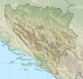
| Géolocalisation sur la carte : Bosnie-Herzégovine
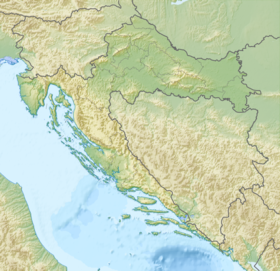
Géolocalisation sur la carte : Croatie
| |||
| modifier |
|||
Références
- Visualisation sur arkod
 Portail de la montagne
  Portail de la Bosnie-Herzégovine
  Portail de la Croatie
На других языках
[de] Kamešnica (Gebirge)
Die Kamešnica ist ein Gebirge teils im Westen Bosnien-Herzegowinas teils im kroatischen Dalmatien. Als Ausläufer des Dinara-Gebirges erstreckt sie sich von Nordwesten bei Vaganj (1173 m) bis zum Stausee Buško jezero. Zu Bosnien-Herzegowina gehört der größte Teil der Kamešnica sowie der Konj (dt. Pferd), deren höchste Erhebung mit 1856 m ü. M. Bei klarem Wetter bietet sie einen hervorragenden Ausblick auf Bosnien und Kroatien, sogar adriatische Inseln sind erkennbar.[en] Kamešnica (mountain)
Kamešnica is a mountain in the Dinarides, located in the southern end of the Dinara Mountain Range on the border between Bosnia and Herzegovina (Canton 10) and Croatia (Dalmatia).[2] It is 1,851 metres (6,073 ft)[3] tall and stretches from the northwest white road pass Vaganj (1173 m) to the Buško Blato artificial lake. The tallest peak is Konj (Horse) 1,855 metres (6,086 ft),[1] which is located in Bosnia and Herzegovina and offer views of both sides of the border. In clear weather, it is possible to see the most remote areas of the Adriatic Sea and its islands. The vicinity's many trails and caves make it popular with hikers.- [fr] Kamešnica (montagne)
Текст в блоке "Читать" взят с сайта "Википедия" и доступен по лицензии Creative Commons Attribution-ShareAlike; в отдельных случаях могут действовать дополнительные условия.
Другой контент может иметь иную лицензию. Перед использованием материалов сайта WikiSort.org внимательно изучите правила лицензирования конкретных элементов наполнения сайта.
Другой контент может иметь иную лицензию. Перед использованием материалов сайта WikiSort.org внимательно изучите правила лицензирования конкретных элементов наполнения сайта.
2019-2025
WikiSort.org - проект по пересортировке и дополнению контента Википедии
WikiSort.org - проект по пересортировке и дополнению контента Википедии