geo.wikisort.org - Montagne
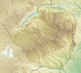
Le mont Inyangani[1] (ou Nyangani) est le point culminant du Zimbabwe, avec une altitude de 2 592 m, et l'un des sommets ultra-proéminents d'Afrique. Il est situé dans l'est du pays, au sud-est de Harare, la capitale, et au nord de Mutare, non loin de la frontière avec le Mozambique.
| Inyangani | |
 Vue depuis l'ouest | |
| Géographie | |
|---|---|
| Altitude | 2 592 m |
| Massif | Monts Inyanga |
| Coordonnées | 18° 18′ 00″ sud, 32° 50′ 31″ est |
| Administration | |
| Pays | |
| Province | Manicaland |
| District | Nyanga |
| Ascension | |
| Voie la plus facile | par l'ouest |
| Géologie | |
| Roches | Dolérite, grès |
| modifier |
|

Plusieurs cours d'eau y prennent leur source, dont le Pungue.
L'Inyangani se trouve au cœur du parc national de Nyanga.
Notes et références
- Search Geonames, National Geospatial-Intelligence Agency, United States Board on Geographic Names
Voir aussi
Article connexe
- Géographie du Zimbabwe
Bibliographie
- (en) Shelley Davidow, In the shadow of Inyangani, Macmillan, Oxford, 2003, 70 p. (ISBN 9780333992463) (fiction)
- (en) Patricia J. Smith, Spirit of Mount Inyangani, Janus, Londres, 1997, 206 p. (ISBN 1857563751) (fiction)
- (en) Robert C. Soper (et al.), Nyanga : ancient fields, settlements and agricultural history in Zimbabwe, British Institute in Eastern Africa, Londres, 2002, 277 p. (ISBN 187256612X) (essai)
- (en) Robert C. Soper, The terrace builders of Nyanga, Weaver Press, Harare, 2006, 82 p. (ISBN 9781779220615) (essai)
Filmographie
- (en) Mysteries of Mount Inyangani, film d'Ingrid Sinclair, Zimbabwe, 1999
Liens externes
- (en) Nyanga National Park
- Portail de la montagne
- Portail du Zimbabwe
На других языках
[de] Inyangani
Der Inyangani oder Mount Nyangani ist mit 2592 m der höchste Berg Simbabwes. Er liegt in den Eastern Highlands nördlich von Mutare im Nyanga-Nationalpark. An seinen Hängen entspringen zahlreiche wichtige Flüsse, darunter der Pungwe, der Gairezi und der Odzi.[en] Mount Nyangani
Mount Nyangani (formerly Mount Inyangani) is the highest mountain in Zimbabwe at 2,592 m (8,504 ft). The mountain is located within Nyanga National Park in Nyanga District, is about 110 km (68 mi) North West Mutare. The summit lies atop a small outcrop of rock around 40m above the surrounding area. The remainder of the peak is a broad moor of mainly rolling hills and plateau with an area of about 8 km2. The edges of this plateau then fall steeply to the east and west sides. The mountain vegetation is largely composed of heath around the summit plateau with evergreen forest along the wetter eastern slopes and grassland to the western side. Annual rainfall totals are high (around 2200 mm) but long spells of dry weather occur during the winter period of May to August. Due to its relatively low altitude and tropical location, snow falls very rarely, last recorded in August 1935.[2]- [fr] Inyangani
[it] Monte Nyangani
Il Monte Nyangani è una montagna dello Zimbabwe. Con la sua altitudine di 2592 metri s.l.m., rappresenta il punto più elevato del territorio di Zimbabwe.La media di atitudine è di circa 1750 m.s.l. e si estende nella regione (anche chiamata provincia) del Manicaland vicino ai confini dello stato.La fauna e la flora non sono molto diverse da quelle caratteristice della regione.Solo la parte più alta presenta caratteristiche strettamente rocciose mentre il resto è formato da degli altopiani verdeggianti.Nonostante il clima dello Zimbabwe,di tipo tropicale, è presente molta umidità e le temperature sono più basse a causa dei forti venti che colpiscono la vetta.[ru] Иньянгани
Иньянгани (англ. Mount Nyangani) — гора в Зимбабве.Текст в блоке "Читать" взят с сайта "Википедия" и доступен по лицензии Creative Commons Attribution-ShareAlike; в отдельных случаях могут действовать дополнительные условия.
Другой контент может иметь иную лицензию. Перед использованием материалов сайта WikiSort.org внимательно изучите правила лицензирования конкретных элементов наполнения сайта.
Другой контент может иметь иную лицензию. Перед использованием материалов сайта WikiSort.org внимательно изучите правила лицензирования конкретных элементов наполнения сайта.
2019-2025
WikiSort.org - проект по пересортировке и дополнению контента Википедии
WikiSort.org - проект по пересортировке и дополнению контента Википедии
