geo.wikisort.org - Montagne
Hoye-Crest est un sommet de la Backbone Mountain (en) situé administrativement dans le comté de Garrett au Maryland, aux États-Unis.
Cet article est une ébauche concernant la montagne et le Maryland.
Vous pouvez partager vos connaissances en l’améliorant (comment ?) selon les recommandations des projets correspondants.
| Hoye-Crest | |||
 Panneau informatif à Hoye-Crest. | |||
| Géographie | |||
|---|---|---|---|
| Altitude | 1 024 m | ||
| Massif | Backbone Mountain (en) (monts Allegheny, Appalaches) | ||
| Coordonnées | 39° 14′ 14″ nord, 79° 29′ 07″ ouest[1] | ||
| Administration | |||
| Pays | |||
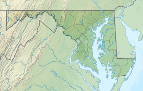
| État | Maryland | ||
| Comté | Garrett | ||
| Géolocalisation sur la carte : Maryland
Géolocalisation sur la carte : États-Unis
| |||
| modifier |
|||

Avec 1 024 mètres d'altitude, c'est le point culminant de l'État.
Notes et références
- Visualisation sur l'USGS.
Liens externes
- Ressource relative à la géographie :
 Portail de la montagne
  Portail du Maryland
На других языках
[de] Hoye-Crest
Der Hoye Crest ist mit seinen 1020 Metern der höchste Berg des Garrett County und des US-Bundesstaates Maryland. Der Berg befindet sich unweit der Grenze zu West Virginia. Auf seinem Gipfel steht eine Markierungstafel, welche genaue Informationen über die Erhebung gibt.[en] Hoye-Crest
Hoye-Crest is a summit along Backbone Mountain just inside of Garrett County, Maryland. It is the highest natural point in Maryland at an elevation of 3,360 feet (1,020 m).[3]- [fr] Hoye-Crest
Текст в блоке "Читать" взят с сайта "Википедия" и доступен по лицензии Creative Commons Attribution-ShareAlike; в отдельных случаях могут действовать дополнительные условия.
Другой контент может иметь иную лицензию. Перед использованием материалов сайта WikiSort.org внимательно изучите правила лицензирования конкретных элементов наполнения сайта.
Другой контент может иметь иную лицензию. Перед использованием материалов сайта WikiSort.org внимательно изучите правила лицензирования конкретных элементов наполнения сайта.
2019-2026
WikiSort.org - проект по пересортировке и дополнению контента Википедии
WikiSort.org - проект по пересортировке и дополнению контента Википедии