geo.wikisort.org - Montagne
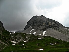
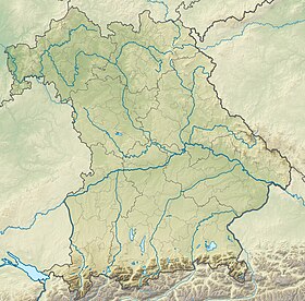
La Hochgundspitze est une montagne culminant à 2 460 m d'altitude dans les Alpes d'Allgäu. Il se situe au sud du Große Steinscharte et au nord-est du Rappenseekopf.
| Hochgundspitze | |
 Vue de la Hochgundspitze depuis le refuge du Rappensee. | |
| Géographie | |
|---|---|
| Altitude | 2 460 m[1],[2] |
| Massif | Alpes d'Allgäu (Alpes) |
| Coordonnées | 47° 17′ 05″ nord, 10° 15′ 46″ est[1],[2] |
| Administration | |
| Pays | |
| Land autrichien Land allemand |
Tyrol Bavière |
| District autrichien District allemand |
Reutte Souabe |
| modifier |
|
Aucun sentier ne mène au sommet de la Hochgundspitze. Même les ascensions les plus faciles exigent de l'expérience en escalade et en randonnée sans chemin tracé. Il y a donc peu d'ascensions.
Notes et références
- (de) Cet article est partiellement ou en totalité issu de l’article de Wikipédia en allemand intitulé « Hochgundspitze » (voir la liste des auteurs).
- Visualisation sur BEV.
- Hochgundspitze sur Bayerische Vermessungsverwaltung.
Bibliographie
- Das schöne Allgäu, 1938, S. 306
- Thaddäus Steiner, Allgäuer Bergnamen, Lindenberg, Kunstverlag Josef Fink, 2007 (ISBN 978-3-89870-389-5)
- Thaddäus Steiner, Die Flurnamen der Gemeinde Oberstdorf im Allgäu, München, Selbstverlag des Verbandes für Flurnamenforschung in Bayern, 1972
- Zettler, Groth, Alpenvereinsführer Allgäuer Alpen, Munich, Bergverlag Rudolf Rother, 1984 (ISBN 3-7633-1111-4)
- Portail de la montagne
- Portail des Alpes
- Portail de la Bavière
- Portail de l'Autriche
На других языках
[de] Hochgundspitze
Die Hochgundspitze ist ein 2460 m hoher Berg in den Allgäuer Alpen.[en] Hochgundspitze
Hochgundspitze is a mountain of Bavaria, Germany.- [fr] Hochgundspitze
Текст в блоке "Читать" взят с сайта "Википедия" и доступен по лицензии Creative Commons Attribution-ShareAlike; в отдельных случаях могут действовать дополнительные условия.
Другой контент может иметь иную лицензию. Перед использованием материалов сайта WikiSort.org внимательно изучите правила лицензирования конкретных элементов наполнения сайта.
Другой контент может иметь иную лицензию. Перед использованием материалов сайта WikiSort.org внимательно изучите правила лицензирования конкретных элементов наполнения сайта.
2019-2025
WikiSort.org - проект по пересортировке и дополнению контента Википедии
WikiSort.org - проект по пересортировке и дополнению контента Википедии


